Southern California Surf 4cast Updated 4 – 24 – 2024
The Surf Forecast will be updated Wednesdays, Fridays and Sundays.
E
Be sure to Sign-up for our free email blast to be notified when the latest Forecast is released! Receive Surf, Shark, & Water Quality Alerts. Stay on top of Local News & Events.
Subscribe Now
THURSDAY Surf Forecast
It’s already been a tough week if your life revolves around a daily surf and your Lions share of happiness is contingent upon getting a few decent waves! Anyway, enough about me… it’s a great time to tackle all of those annoying tasks you’ve been pushing off for a while. That 1-3 hour time gap, usually reserved for surfing in the morning, is gapingly, wide open right now.
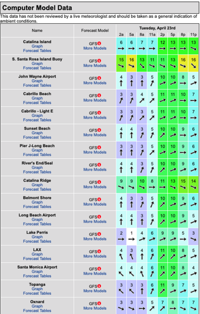
The winds look to be slightly off their “A” game for the rest of the week and we will be reliant upon wind swell for surf… but the silver lining is that waves will increase in size Friday through Monday, so even if the conditions aren’t the greatest there should be something to ride.
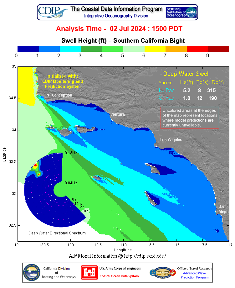
As of today… Nothing much new to report, but we should have small, but arguably, rideable waves through the AM for both the South and West facing beaches. There is no 1 swell you can really put your finger on, but there are some hushed pulses bopping around.
The tide will be on a slow rise through the prime time morning surf hours.
Thursday
2024-04-25 Thu 05:03 AM -0.34′ Low
2024-04-25 Thu 06:10 AM Sunrise
2024-04-25 Thu 06:56 AM Moonset
2024-04-25 Thu 11:21 AM 3.47′ High
2024-04-25 Thu 04:03 PM 1.88′ Low
2024-04-25 Thu 07:33 PM Sunset
2024-04-25 Thu 09:41 PM Moonrise
2024-04-25 Thu 10:24 PM 5.60′ High
The conditions – The conditions should be tolerable until around noon with variable onshore winds that grow in strength throughout the day. The air temp holds at 62 degrees.
FRIDAY Surf Forecast
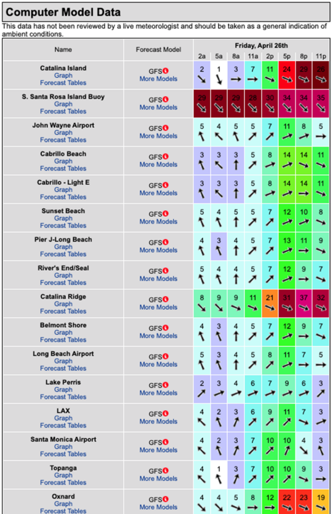
So far, an increase in NW wind swell looks to be our best bet for decent surf. We should see waist to chest high, NW wind swell from 310 degrees with 9-10 second intervals. Smaller, nondescript, pulses of SW will linger in the background.
Tide starts out LOW early and creeps up to 3.17 feet shortly after noon – Fri 05:44 AM -0.34′ Low
Friday
2024-04-26 Fri 05:44 AM -0.34′ Low
2024-04-26 Fri 06:09 AM Sunrise
2024-04-26 Fri 07:34 AM Moonset
2024-04-26 Fri 12:11 PM 3.17′ High
2024-04-26 Fri 04:23 PM 2.17′ Low
2024-04-26 Fri 07:34 PM Sunset
2024-04-26 Fri 10:44 PM Moonrise
2024-04-26 Fri 10:54 PM 5.54′ High
The conditions – There winds look to blow out of the South again, but the sea surface should be okay until around noon, followed by stronger SW breezes into the afternoon. The air temp jumps up to 65 degrees.
SATURDAY Surf Forecast
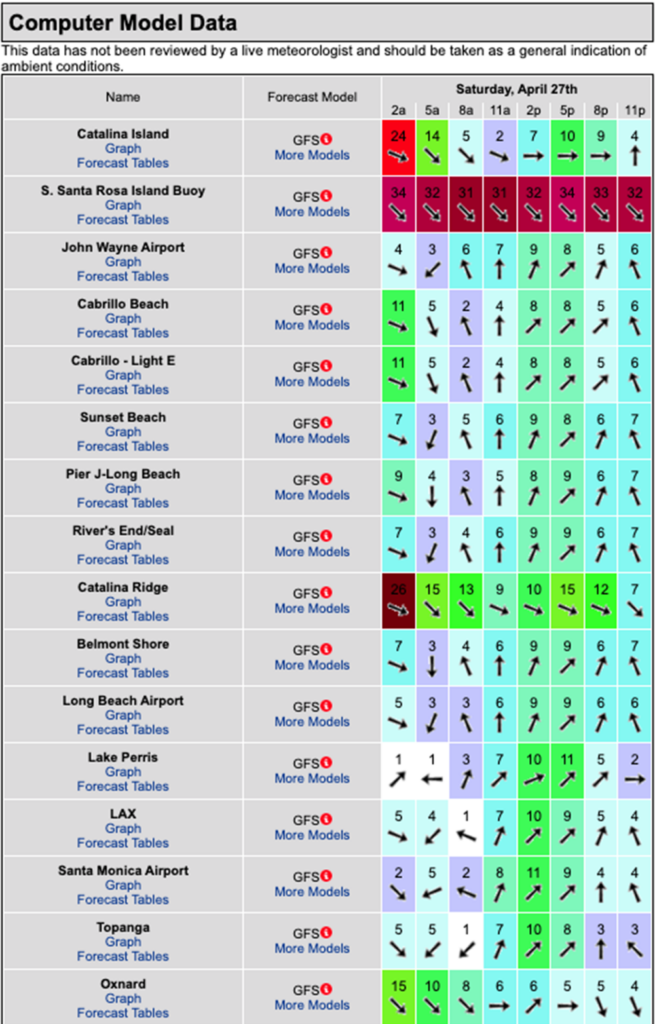
For lack of a better addage, we’ll call Saturday the “Money Day” of the week. We are slated to see chest to shoulder high + NW wind swell for the exposed West facing breaks. The angle will be from that 310 degrees with 9-10 second intervals.
The tub is drained for the dawn patrollers – Sat 06:32 AM -0.25′ Low
Saturday
2024-04-27 Sat 06:08 AM Sunrise
2024-04-27 Sat 06:32 AM -0.25′ Low
2024-04-27 Sat 08:20 AM Moonset
2024-04-27 Sat 01:16 PM 2.90′ High
2024-04-27 Sat 04:42 PM 2.45′ Low
2024-04-27 Sat 07:35 PM Sunset
2024-04-27 Sat 11:30 PM 5.39′ High
2024-04-27 Sat 11:46 PM Moonrise
The conditions – There winds look a little off, but nothing too dramatic with a mixed bag of direction through the morning followed by stronger SW breezes into the afternoon. The air temp tops out at 65 degrees.
SUNDAY Surf Forecast
We should see continued NW wind swell in the waist to chest high range. Same 310 degree angle with similar 9 -10 second intervals.
Notable tide – Sun 07:31 AM -0.12′ Low
Sunday
2024-04-28 Sun 06:07 AM Sunrise
2024-04-28 Sun 07:31 AM -0.12′ Low
2024-04-28 Sun 09:15 AM Moonset
2024-04-28 Sun 03:00 PM 2.79′ High
2024-04-28 Sun 04:58 PM 2.72′ Low
2024-04-28 Sun 07:36 PM Sunset
The conditions – The conditions should be okay until around 11:00AM with variable, Southerly winds that barely grow in strength into the afternoon. The air temp holds at 66 degrees.
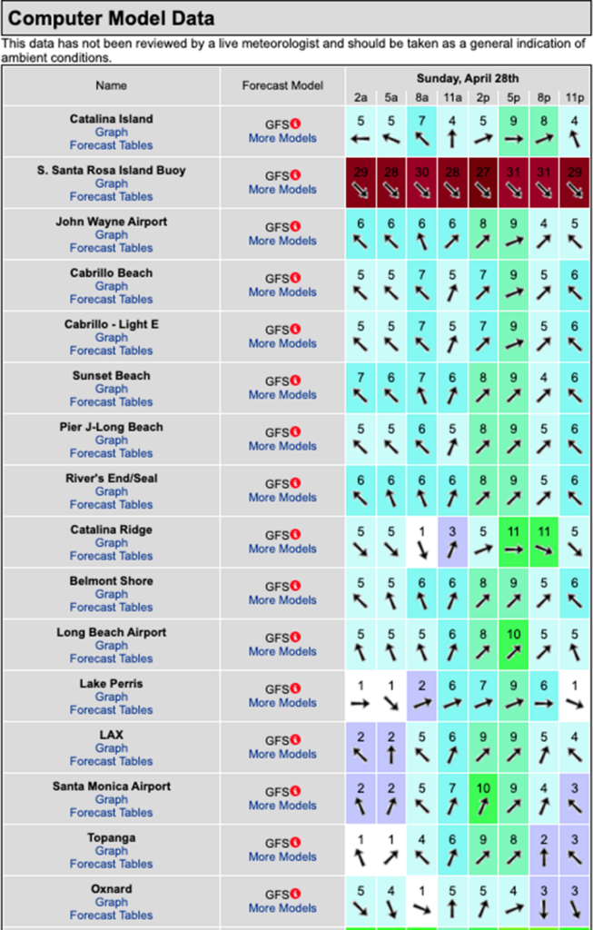
MONDAY Surf Forecast
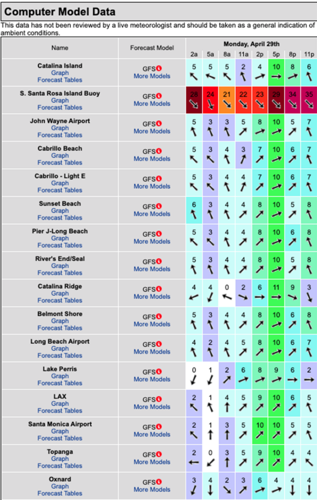
More of the same scenario, but smaller… waist high + NW wind swell for the top West facing beaches.
Notable tide – Mon 08:43 AM -0.03′ Low
Monday
2024-04-29 Mon 12:17 AM 5.14′ High
2024-04-29 Mon 12:43 AM Moonrise
2024-04-29 Mon 06:06 AM Sunrise
2024-04-29 Mon 08:43 AM -0.03′ Low
2024-04-29 Mon 10:17 AM Moonset
2024-04-29 Mon 07:36 PM Sunset
The conditions – There winds look to blow out of the South, with a side shore element to them until noon followed by stronger SW breezes into the afternoon. The air temp jumps up to a toasty 69 degrees.
Water Temps are as follows, (day of 4CAST update), Malibu 57, Santa Monica 59, South Bay 60,
Huntington 62, Newport 62.
I will be back on Friday with the next update.
About the Swell Magnet Forecast
One of the most exciting–and yet most challenging–aspects of surfing is the sheer variety of waves and weather conditions that affect the entire surfing experience. Any surfer who is interested in going beyond the most basic level of surfing will have to develop the ability to interpret waves and environmental conditions. This is important for ensuring both a safe and enjoyable experience.
The main difficulty lies in predicting how exactly the ocean and the environment will behave at any given time. One day, you could be riding four-footers all day and the next, you might be facing a glasslike surface with nary a ripple. Conditions can change drastically from day-to-day and even within the space of a couple of hours. To avoid wasted time and unproductive trips to the surf, it is essential to have access to reliable information on surf conditions.
Sites such as Swellmagnet.com offer up-to-the-minute surf reports that are essential to all California surfers. The company relies on an extensive network of surf cams and surf experts in order to monitor the precise surf conditions on any given day. All information is collated and analyzed by qualified surf specialists, with the resulting data being provided to the public via the Swellmagnet site.
Swellmagnet provides some of the best surf reports in the industry, with accurate and verifiable results gathered via an innovative system of surf condition monitors and detectors. Expert surf analysis is provided by the company’s team of highly experienced specialists, each with long years of experience monitoring and actually experiencing the full range of surf conditions. This combination of state-of-the-art technology and extensive practical experience ensures the highest quality and most accurate surf reports available.
For surfers who wish to take full advantage of the best that the California coast has to offer, the services provided by Swellmagnet are essential.


