_______________________________________________________________________________________________________
SOUTHERN CALIFORNIA SURF FORECAST UPDATED on 2-23-18
_______________________________________________________________________________________________________
If you are having problems getting the streams please try using the “Chrome Browser” for all devices, (including Android). Click here for troubleshooting tips! Or feel free to email us for technical support contact us
_______________________________________________________________________________________________________
Good news! The SWELLMAGNET APP is up and running and we moved the website to a new high end server which has made the data load lightning fast. If you haven’t downloaded the APP just type in swellmagnet.com in the App store! It’s 100% FREE! If you have any issues with the APP or the site itself please take a second to let us know. We hope to have everything fine tuned ASAP! contact us
_______________________________________________________________________________________________________
For Monday morning all swell will be on the fade leaving us with waist high + peaks for the better West facing beaches.
Monday
2018-02-26 Mon 03:48 AM Moonset
2018-02-26 Mon 05:59 AM 5.84 feet High Tide
2018-02-26 Mon 06:26 AM Sunrise
2018-02-26 Mon 01:12 PM -1.02 feet Low Tide
2018-02-26 Mon 02:24 PM Moonrise
2018-02-26 Mon 05:47 PM Sunset
2018-02-26 Mon 07:43 PM 4.01 feet High Tide
The conditions look good with E/NE/NNE breezes in the 4-7 MPH zone until noon and then 7-11 MPH out of the West in the afternoon. The air temp tops out at 63 degrees.
______________________________________________________________________________________________________
For Tuesday morning we should get a nice boost of NW wind swell from a steep 310-315 degrees and 12-13 second intervals. The exposed West facing breaks should see chest to shoulder high peaks with possibly some larger waves mixing in.
Fat tides for the morning session: 06:52 AM 6.19 feet High Tide
Tuesday
2018-02-27 Tue 12:42 AM 1.59 feet Low Tide
2018-02-27 Tue 04:43 AM Moonset
2018-02-27 Tue 06:25 AM Sunrise
2018-02-27 Tue 06:52 AM 6.19 feet High Tide
2018-02-27 Tue 01:54 PM -1.31 feet Low Tide
2018-02-27 Tue 03:31 PM Moonrise
2018-02-27 Tue 05:48 PM Sunset
2018-02-27 Tue 08:19 PM 4.36 feet High Tide
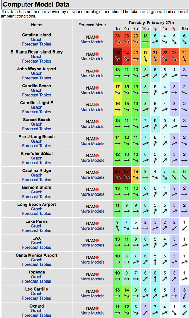
The conditions are all over the place See wind models below. The air temp to 59 degrees and there’s a 20% chance of rain.

______________________________________________________________________________________________________
For Wednesday morning we’ll see that NW wind swell back down into the waist to chest high range.
It will continue to roll in from that steep 310 degree angle with slightly shorter 10-11 second intervals.
Fat tides for the morning session: 07:40 AM 6.37 feet High Tide
Wednesday
2018-02-28 Wed 01:32 AM 1.17 feet Low Tide
2018-02-28 Wed 05:32 AM Moonset
2018-02-28 Wed 06:23 AM Sunrise
2018-02-28 Wed 07:40 AM 6.37 feet High Tide
2018-02-28 Wed 02:33 PM -1.38 feet Low Tide
2018-02-28 Wed 04:39 PM Moonrise
2018-02-28 Wed 05:49 PM Sunset
2018-02-28 Wed 08:54 PM 4.66 feet High Tide
The conditions look to improve with variable winds out of the East in the 2-6 MPH range until noon and 6-9 MPH out of the West in the afternoon. The air temp tops out at 60 degrees.
______________________________________________________________________________________________________
For Thursday morning that NW energy will dip into the waist high range.
Fat tides for the morning session: 06:52 AM 6.19 feet High Tide
Thursday
2018-03-01 Thu 02:19 AM 0.81 feet Low Tide
2018-03-01 Thu 06:17 AM Moonset
2018-03-01 Thu 06:22 AM Sunrise
2018-03-01 Thu 08:26 AM 6.34 feet High Tide
2018-03-01 Thu 03:10 PM -1.25 feet Low Tide
2018-03-01 Thu 04:52 PM Full Moon
2018-03-01 Thu 05:47 PM Moonrise
2018-03-01 Thu 05:50 PM Sunset
2018-03-01 Thu 09:28 PM 4.88 feet High Tide
The conditions look pretty good again with variable winds out of the NE/NNE in the 3-8 MPH range until noon, (stronger below passes and canyons), and 8-12 MPH out of the West in the afternoon. The air temp tops out at 65 degrees.
______________________________________________________________________________________________________
Water Temps are as follows – Malibu 54, Santa Monica 57, Hermosa 57, Huntington 53 and Newport 56 degrees.
______________________________________________________________________________________________________
I’ll be back on Tuesday with the 5day 4cast!
______________________________________________________________________________________________________
ABOUT THE SWELLMAGNET FORECAST – One of the most exciting–and yet most challenging–aspects of surfing is the sheer variety of waves and weather conditions that affect the entire surfing experience. Any surfer who is interested in going beyond the most basic level of surfing will have to develop the ability to interpret waves and environmental conditions. This is important for ensuring both a safe and enjoyable experience.
The main difficulty lies in predicting how exactly the ocean and the environment will behave at any given time. One day, you could be riding four-footers all day and the next, you might be facing a glasslike surface with nary a ripple. Conditions can change drastically from day-to-day and even within the space of a couple of hours. To avoid wasted time and unproductive trips to the surf, it is essential to have access to reliable information on surf conditions.
Sites such as Swellmagnet.com offer up-to-the-minute surf reports that are essential to all California surfers. The company relies on an extensive network of surf cams and surf experts in order to monitor the precise surf conditions on any given day. All information is collated and analyzed by qualified surf specialists, with the resulting data being provided to the public via the Swellmagnet site.
Swellmagnet provides some of the best surf reports in the industry, with accurate and verifiable results gathered via an innovative system of surf condition monitors and detectors. Expert surf analysis is provided by the company’s team of highly experienced specialists, each with long years of experience monitoring and actually experiencing the full range of surf conditions. This combination of state-of-the-art technology and extensive practical experience ensures the highest quality and most accurate surf reports available.
For surfers who wish to take full advantage of the best that the California coast has to offer, the services provided by Swellmagnet are essential.
