_______________________________________________________________________________________________________
SOUTHERN CALIFORNIA SURF FORECAST UPDATED on 1-4-19
_______________________________________________________________________________________________________
For Saturday morning the incremental swell increase will continue and deliver shoulder to head high + surf to the West facing breaks. The energy will roll in from that same 285-300 degree angle with 14-15 second intervals. The morning tides have been merciless all week, either completely shutting things down, or forcing large crowds into a tight, competitive take off zone. Hopefully this new burst of energy will win the battle of the tide bulge!
Big morning tide again: 08:13 AM 6.05 feet High Tide
Saturday
2019-01-05 Sat 01:58 AM 2.20 feet Low Tide
2019-01-05 Sat 06:39 AM Moonrise
2019-01-05 Sat 07:00 AM Sunrise
2019-01-05 Sat 08:13 AM 6.05 feet High Tide
2019-01-05 Sat 03:29 PM -0.78 feet Low Tide
2019-01-05 Sat 04:55 PM Moonset
2019-01-05 Sat 04:58 PM Sunset
2019-01-05 Sat 05:29 PM New Moon
2019-01-05 Sat 10:01 PM 3.72 feet High Tide
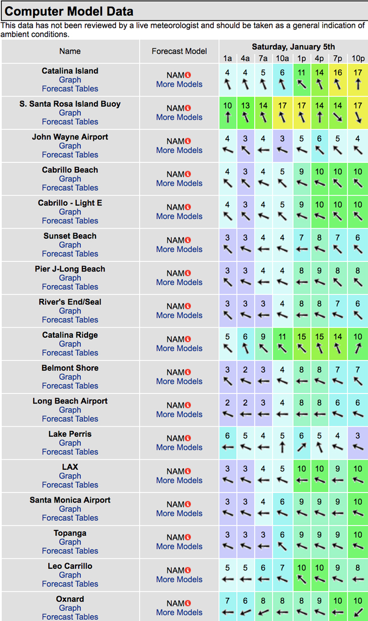
The conditions look interesting as some weather moves in. Wind models are calling for 7-13 MPH winds out of the E/SE/SSE all day long. There’s a 100% chance of rain, (starting in the late afternoon), and the air temp tops out at 61 degrees.

______________________________________________________________________________________________________
For Sunday morning the surf should pick up significantly with OH to WOH sets at the top West facing beaches. The swell angle rolls in from a 290-300 degrees with 14-15 second intervals. It is slated to have rained all through Saturday night, so even if it’s pumping you may want to weigh the consequences of paddling in raw sewage in order to get barreled.
Tidal issues: 08:44 AM 5.95 feet High Tide – If the surf is up it won’t matter too much!
Beware of the Urban Runoff – It is advised to stay out of the water for 72 hours following any measurable rain fall. It’s always a roll of the dice, especially after a major downpour. The threat of getting sick is very real so if you do insist on taking the plunge be sure to use ear plugs an upon exiting the ocean rinse off in hot water, use some alcohol based ear drops and a nasal netti pot rinse for good measure never hurt anybody.
Sunday
2019-01-06 Sun 02:31 AM 2.24 feet Low Tide
2019-01-06 Sun 07:00 AM Sunrise
2019-01-06 Sun 07:27 AM Moonrise
2019-01-06 Sun 08:44 AM 5.95 feet High Tide
2019-01-06 Sun 04:02 PM -0.69 feet Low Tide
2019-01-06 Sun 04:59 PM Sunset
2019-01-06 Sun 05:47 PM Moonset
2019-01-06 Sun 10:35 PM 3.70 feet High Tide
The conditions look much better on today’s model run, with variable breezes out of the East at 2-6 MPH until noon and mild 2-3 MPH whispers out of the SW at 1-3 MPH in the afternoon. The air temp dips to 59 degrees.
______________________________________________________________________________________________________
For Monday morning we’ll see a drop in size, but there will still be plenty of surf left with head high to possibly OH sets from a 290-295 degree angle.
Morning tides start to get more reasonable but remain full: 09:16 AM 5.78 feet High Tide
Beware of the Urban Runoff from Sat night – It is advised to stay out of the water for 72 hours following any measurable rainfall.
Monday
2019-01-07 Mon 03:03 AM 2.29 feet Low Tide
2019-01-07 Mon 07:00 AM Sunrise
2019-01-07 Mon 08:11 AM Moonrise
2019-01-07 Mon 09:16 AM 5.78 feet High Tide
2019-01-07 Mon 04:34 PM -0.53 feet Low Tide
2019-01-07 Mon 05:00 PM Sunset
2019-01-07 Mon 06:41 PM Moonset
2019-01-07 Mon 11:09 PM 3.67 feet High Tide
The conditions look pretty good with variable breezes out of the East at 2-4 MPH until noon and 6-9 MPH winds out of the West in the afternoon. There’s a 10% chance of rain and the air temp tops out at 61 degrees.
______________________________________________________________________________________________________
For Tuesday morning we’ll see another little drop in size but the West facing beaches will dish up chest to head high sets from a 290-300 degree angle with shorter, 11-13 second intervals.
Beware of the Urban Runoff – It is advised to stay out of the water for 72 hours following any measurable rainfall.
Tuesday
2019-01-08 Tue 03:37 AM 2.35 feet Low Tide
2019-01-08 Tue 07:00 AM Sunrise
2019-01-08 Tue 08:51 AM Moonrise
2019-01-08 Tue 09:47 AM 5.53 feet High Tide
2019-01-08 Tue 05:01 PM Sunset
2019-01-08 Tue 05:06 PM -0.30 feet Low Tide
2019-01-08 Tue 07:35 PM Moonset
2019-01-08 Tue 11:45 PM 3.66 feet High Tide
The conditions look fantastic with variable breezes out of the East at 4-9 MPH all day long. The air holds at 66 degrees.
______________________________________________________________________________________________________
For Wednesday morning we’ll see another significant swell ramble into town. This energy will come down the line from a 290-300 degree angle with 14-16 second intervals and is projected to fill in through the day. From what I can tell today… looks like things should start off head high + and get
into the WOH zone late morning/early afternoon. Stay tuned for details on Sunday!
Wednesday
2019-01-09 Wed 04:15 AM 2.44 feet Low Tide
2019-01-09 Wed 07:00 AM Sunrise
2019-01-09 Wed 09:26 AM Moonrise
2019-01-09 Wed 10:20 AM 5.19 feet High Tide
2019-01-09 Wed 05:02 PM Sunset
2019-01-09 Wed 05:39 PM -0.02 feet Low Tide
2019-01-09 Wed 08:29 PM Moonset
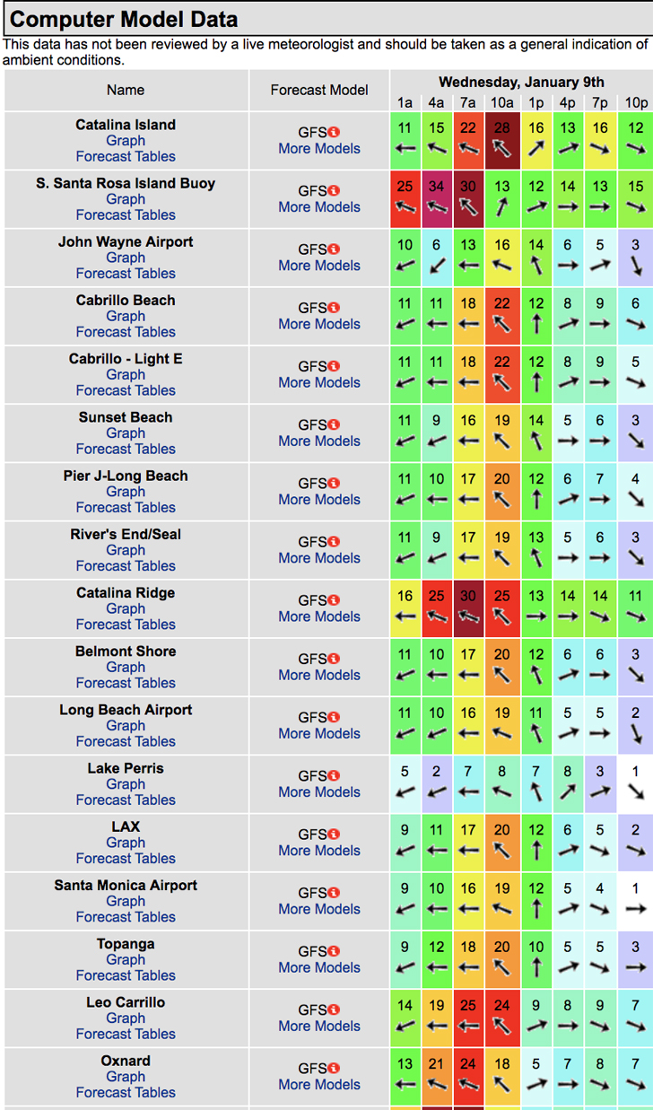
The conditions look pretty interesting as another rain storm blows into town, (see below for wind projections). There’s a 90% chance of rain and the air temp tops out at 61 degrees.

______________________________________________________________________________________________________
Water temps are as follows, (day of 4CAST update) and are as follows: Malibu 57 Santa Monica 60 South Bay 59, Huntington 56, Newport 56.
______________________________________________________________________________________________________
The next 4CAST will be posted on Sunday!
______________________________________________________________________________________________________
ABOUT THE SWELLMAGNET FORECAST – One of the most exciting–and yet most challenging–aspects of surfing is the sheer variety of waves and weather conditions that affect the entire surfing experience. Any surfer who is interested in going beyond the most basic level of surfing will have to develop the ability to interpret waves and environmental conditions. This is important for ensuring both a safe and enjoyable experience.
The main difficulty lies in predicting how exactly the ocean and the environment will behave at any given time. One day, you could be riding four-footers all day and the next, you might be facing a glasslike surface with nary a ripple. Conditions can change drastically from day-to-day and even within the space of a couple of hours. To avoid wasted time and unproductive trips to the surf, it is essential to have access to reliable information on surf conditions.
Sites such as Swellmagnet.com offer up-to-the-minute surf reports that are essential to all California surfers. The company relies on an extensive network of surf cams and surf experts in order to monitor the precise surf conditions on any given day. All information is collated and analyzed by qualified surf specialists, with the resulting data being provided to the public via the Swellmagnet site.
Swellmagnet provides some of the best surf reports in the industry, with accurate and verifiable results gathered via an innovative system of surf condition monitors and detectors. Expert surf analysis is provided by the company’s team of highly experienced specialists, each with long years of experience monitoring and actually experiencing the full range of surf conditions. This combination of state-of-the-art technology and extensive practical experience ensures the highest quality and most accurate surf reports available.
For surfers who wish to take full advantage of the best that the California coast has to offer, the services provided by Swellmagnet are essential.
