______________________________________________________________________________
SOUTHERN CALIFORNIA SURF FORECAST UPDATED 3-8-16
______________________________________________________________________________
If anyone is still having problems getting the streams please try the “Chrome Browser” for now. We are still trying to iron out a few kinks! Android users that are having problems will need to download the “Puffin Browser”. Feel free to email us for technical support contact us
______________________________________________________________________________
Beware of the Urban Runoff – It is advised to stay out of the water for 72 hours following any measurable rain fall. It’s always a roll of the dice, especially after a major downpour. The threat of getting sick is very real, so if you do insist on taking the plunge be sure to use ear plugs and upon exiting the ocean rinse off in hot water, use some alcohol based ear drops, and a nasal netti pot rinse for good measure never hurt anybody.
______________________________________________________________________________
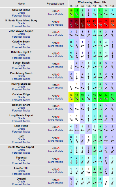
For Wednesday morning the swell will back down a bit, but continue to churn out solid surf, with the better West facing breaks dishing up OH to well OH sets from that same 285-295 degree angle. The winds are supposed to relax quite a bit but I’m not promising clean conditions, (especially under the surface).
Wednesday
2016-03-09 Wed 03:02 AM 0.18 feet Low Tide
2016-03-09 Wed 06:11 AM Sunrise
2016-03-09 Wed 06:37 AM Moonrise
2016-03-09 Wed 09:10 AM 5.85 feet High Tide
2016-03-09 Wed 03:34 PM -0.69 feet Low Tide
2016-03-09 Wed 05:57 PM Sunset
2016-03-09 Wed 07:01 PM Moonset
2016-03-09 Wed 09:46 PM 5.39 feet High Tide
The conditions should be okay with variable 1-4 MPH breezes until 11AM and 6-10 MPH out of the West in the afternoon. The air temp tops out at 69 degrees.

______________________________________________________________________________
For Thursday morning the swell will continue to drop, but there will still be plenty of waves as the better West facing breaks continue to produce shoulder to head high + surf from a 285-290 degree angle with 12-14 second intervals.
It looks like we’ll see some fresh ground swell start to weave its way into the mix later in the afternoon. This energy will be a bit steeper than the last few swells moving down the line at a 300-305 degree angle with 14-16 second intervals.
Thursday
2016-03-10 Thu 03:49 AM -0.04 feet Low Tide
2016-03-10 Thu 06:10 AM Sunrise
2016-03-10 Thu 07:19 AM Moonrise
2016-03-10 Thu 09:57 AM 5.47 feet High Tide
2016-03-10 Thu 04:10 PM -0.30 feet Low Tide
2016-03-10 Thu 05:58 PM Sunset
2016-03-10 Thu 08:10 PM Moonset
2016-03-10 Thu 10:24 PM 5.53 feet High Tide
The conditions look okay early with light and variable winds at 2-4 MPH until noon and 10-12 MPH out of the West in the afternoon. The air temp tops out at 69 degrees.
______________________________________________________________________________
For Friday morning we’ll start off with shoulder to head high + sets from that same steeper angle. The top West facing breaks will definitely have the most action for the morning, but another round of beefy swell will be arriving right on its heels, so look for a substantial jump in size on Saturday morning.
Friday
2016-03-11 Fri 04:40 AM -0.10 feet Low Tide
2016-03-11 Fri 06:09 AM Sunrise
2016-03-11 Fri 08:02 AM Moonrise
2016-03-11 Fri 10:47 AM 4.90 feet High Tide
2016-03-11 Fri 04:48 PM 0.23 feet Low Tide
2016-03-11 Fri 05:59 PM Sunset
2016-03-11 Fri 09:18 PM Moonset
2016-03-11 Fri 11:06 PM 5.52 feet High Tide
The conditions start off okay early with variable 1-4 MPH breezes until 10AM, but that doesn’t last long, with double digit onshore gusts whipping up shortly after that and increasing up to as high as 25 MPH in some locations.There is a 70% chance of rain and the air temp dips to 64 degrees.
______________________________________________________________________________
Saturday morning looks like another real bruiser with OH +, (to possible DOH at the top deep water West facing beaches). This swell looks to be pretty consistent with 12-14 second intervals from a Westerly, 280-290 degree angle.
* Be advised, if it rains hard on Friday, that 72 stay out of the water, (dodging Urban Runoff rule), comes into play.
Saturday
2016-03-12 Sat 05:36 AM -0.00 feet Low Tide
2016-03-12 Sat 06:07 AM Sunrise
2016-03-12 Sat 08:46 AM Moonrise
2016-03-12 Sat 11:45 AM 4.22 feet High Tide
2016-03-12 Sat 05:30 PM 0.84 feet Low Tide
2016-03-12 Sat 05:59 PM Sunset
2016-03-12 Sat 10:25 PM Moonset
2016-03-12 Sat 11:53 PM 5.37 feet High Tide
The conditions could go either way for the AM. The sea surface will be hard pressed to smooth out overnight with all of the winds on Friday… but I’ve seen stranger things happen. On paper we have variable 2-4 MPH winds early and those increase to 9-14 MPH in the afternoon. The air temp holds steady at 64 degrees.
______________________________________________________________________________
Sunday morning looks a bit smaller, but there will still be plenty of “PUMP” out there with OH + surf for the best West facing beaches. The direction will remain a 280 + degrees and the intervals will drop to 12 seconds.
Sunday
2016-03-13 Sun 07:06 AM Sunrise
2016-03-13 Sun 07:43 AM 0.19 feet Low Tide
2016-03-13 Sun 10:33 AM Moonrise
2016-03-13 Sun 01:57 PM 3.58 feet High Tide
2016-03-13 Sun 07:00 PM Sunset
2016-03-13 Sun 07:18 PM 1.47 feet Low Tide
The conditions may be alright, with variable, 2-4 MPH winds until noon and then those jump up to 9-14 MPH out of the West after that. The air temp tops out at 63 degrees.
______________________________________________________________________________
Water Temps: dip a bit but not too bad yet – Malibu 58, Santa Monica 62, Hermosa 62, Huntington 60 & Newport 62 degrees.
______________________________________________________________________________
I’ll be back on Wednesday with the next update!
______________________________________________________________________________
