______________________________________________________________________________
[easyrotator]erc_14_1408833474[/easyrotator]
Today’s Slideshow is courtesy of Brian McStotts – The Wedge 8-23-14
Check out more pics
______________________________________________________________________________
SOUTHERN CALIFORNIA SURF FORECAST UPDATED 8-23-14
______________________________________________________________________________
SHARK UPDATE To see the latest shark updates follow us on Facebook Check it out!
______________________________________________________________________________

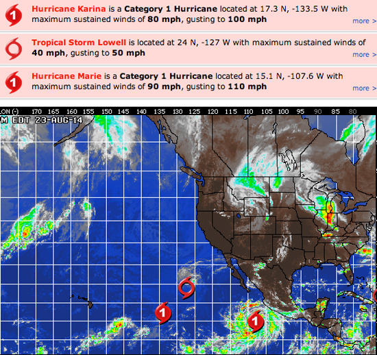
HURRICANE WATCH August 23, 2014 – While the Eastern Pacific Basin currently has three named storms, the one of most interest is Hurricane Marie which is located several hundred miles to the south of Baja California. Marie is tracking over very warm waters and this environment will persist for the next 48 hours, leading to rapid strengthening. AccuWeather.com Meteorologists are expecting Marie to become a major hurricane sometime on Sunday. The good news is that Marie will remain over the open waters of the Eastern Pacific Ocean as it tracks toward the west-northwest, generally moving parallel to the Mexican coast. However, rough surf and dangerous rip currents produced by Marie will spread northwestward through the remainder of the weekend, affecting parts of Baja California. Enhanced surf and rip currents associated with Marie will spread across southern California beaches by the middle of next week.
Elsewhere across the Pacific, Tropical Storm Lowell is located over the open waters, several hundred miles west of Baja California. Lowell is producing rough surf and large swells from southern California through Baja California. Lowell is tracking into cooler waters as it slowly moves northwesterly. It is likely that Lowell will degenerate into a remnant area of low pressure by Saturday night.
Hurricane Karina is located over 1,300 miles east of Hilo, Hawaii, tracking toward the northeast at the present time. Karina will continue on a northeastward track, moving into a more hostile environment through the middle of next week. Gradual weakening is expected to occur as this happens. Karina will have no impact to any land masses through the rest of the duration of its life.
______________________________________________________________________________
On Sunday morning will see decreasing Lowell swell and some fresh Southerly ground swell from a liberal 220 degree angle. That energy, coupled with Lowell leftovers should make for some fun chest to shoulder high plus sets for the top spots.
Sunday
2014-08-24 Sun 03:39 AM 0.12 feet Low Tide
2014-08-24 Sun 05:36 AM Moonrise
2014-08-24 Sun 06:22 AM Sunrise
2014-08-24 Sun 09:56 AM 4.50 feet High Tide
2014-08-24 Sun 03:20 PM 1.67 feet Low Tide
2014-08-24 Sun 06:52 PM Moonset
2014-08-24 Sun 07:29 PM Sunset
2014-08-24 Sun 09:23 PM 5.68 feet High Tide
The conditions look tolerable with light onshore winds in the 1-5 MPH zone until 11AM and then those pick up to 10-15 MPH in the afternoon. The air temp tops out at 75 degrees.
___________________________________________________________________________
Monday morning we’ll be left with the last traces of Lowell swell and continued solid SW ground swell from that same 220 degree angle. The best South facing beaches should see sets in the shoulder high plus range.
Monday
2014-08-25 Mon 04:03 AM 0.22 feet Low Tide
2014-08-25 Mon 06:22 AM Sunrise
2014-08-25 Mon 06:30 AM Moonrise
2014-08-25 Mon 07:13 AM New Moon
2014-08-25 Mon 10:18 AM 4.63 feet High Tide
2014-08-25 Mon 03:51 PM 1.52 feet Low Tide
2014-08-25 Mon 07:25 PM Moonset
2014-08-25 Mon 07:28 PM Sunset
2014-08-25 Mon 09:54 PM 5.55 feet High Tide
Tuesday
The conditions look okay with variable winds, out of the West, in the 1-5 MPH zone until 10AM and then those pick up to 10-12 MPH in the afternoon. The air temp tops out at 80 degrees.
___________________________________________________________________________
By Tuesday morning we should see a little boost in size for the most exposed South facing beaches courtesy of what has become Tropical Storm Marie. We’ll also see fading SW ground swell. Kind of tough to predict size until we see what marie actually does, but projections tell me it should go at least chest to shoulder high… maybe bigger.
2014-08-26 Tue 04:27 AM 0.37 feet Low Tide
2014-08-26 Tue 06:23 AM Sunrise
2014-08-26 Tue 07:23 AM Moonrise
2014-08-26 Tue 10:42 AM 4.75 feet High Tide
2014-08-26 Tue 04:24 PM 1.43 feet Low Tide
2014-08-26 Tue 07:27 PM Sunset
2014-08-26 Tue 07:57 PM Moonset
2014-08-26 Tue 10:25 PM 5.32 feet High Tide
The conditions look okay with light winds in the 1-3 MPH zone until 10AM and then those pick up to 10-12 MPH in the afternoon. The air temp tops out at 82 degrees.
___________________________________________________________________________
The current water temps Newport 70 degrees, Huntington 68 degrees, the South Bay showed as 73 degrees, Santa Monica 71 degrees and Malibu 70 degrees.
______________________________________________________________________________
I’ll be back on Sunday with the next update.
______________________________________________________________________________
