______________________________________________________________________________
[easyrotator]erc_47_1407435195[/easyrotator]
Shots courtesy of our friends at Kandui Surf Resort – Indonesia
______________________________________________________________________________
SOUTHERN CALIFORNIA SURF FORECAST UPDATED 8-8-14
______________________________________________________________________________
SHARK UPDATE To see the latest shark updates follow us on Facebook Check it out!
______________________________________________________________________________

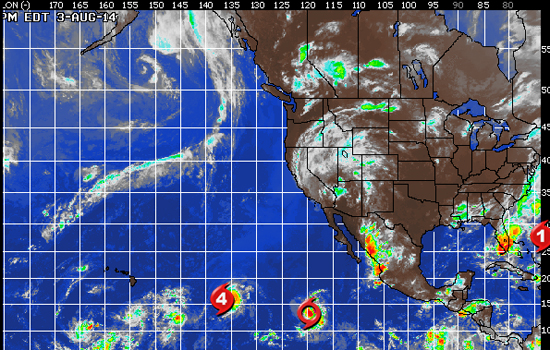
HURRICANE WATCH August 7, 2014 – Hurricane Iselle remains a Category 1 storm with sustained wind of 90 mph and higher gusts. Iselle will continue to track west-northwest toward Hawaii. Meanwhile, Hurricane Julio is located northeast of Iselle and is also tracking west-northwest, now as a Category 2 hurricane.
Hurricane Iselle is currently located about 350 miles east-southeast of Hilo, Hawaii. Large sea waves and swells, rough surf and strong rip currents will be the first impacts felt by the Big Island and Maui as Iselle approaches. The wind will increase across the Big Island later today, especially across the higher terrain, where wind gusts can exceed 75 mph. Wind gusts in excess of 60 mph will impact Maui late today and into tonight. This will likely result in widespread disruption of power. Rainfall amounts of 4 inches or greater, locally in excess of 8 inches, will lead to life threatening flooding and mudslides, especially over the foothills of the Big Island. The heavy rain may also lead to road washouts. Iselle will impact the rest of the islands with flooding rainfall and locally damaging wind gusts late tonight and Friday.
Hurricane Julio is centered about 1,340 miles east of Hilo, Hawaii, with maximum sustained winds now up to 100 mph. Julio will continue to strengthen across the eastern Pacific on a course that will take it near Hawaii later this weekend. Julio is tracking over warm waters, so slow strengthening will continue over the next 12-24 hours. However, Julio should then weaken as it encounters cooler waters and drier air by the time it gets close to Hawaii. Depending on the exact track, it could produce strong winds and flooding rain to some of the northern islands later this weekend. Recent computer models continue to show Julio passing north and east of Hawaii late this weekend which would cause less impact on the islands. However, a shift farther south with the models is not out of the question and Hawaii will need to continue to monitor the situation.
______________________________________________________________________________
Saturday morning looks a bit smaller with all South swell backing off through the day. The better South facing breaks should see inconsistent waist to chest high sets.
We’ll also see some light, waist high, short interval, (6-8 seconds from a steep 310 degree angle), NW wind swell for the better West facing beaches.
* Decent tide push through the early morning.
Saturday
2014-08-09 Sat 03:08 AM -0.96 feet Low Tide
2014-08-09 Sat 04:57 AM Moonset
2014-08-09 Sat 06:11 AM Sunrise
2014-08-09 Sat 09:26 AM 4.55 feet High Tide
2014-08-09 Sat 02:38 PM 1.44 feet Low Tide
2014-08-09 Sat 06:53 PM Moonrise
2014-08-09 Sat 07:47 PM Sunset
2014-08-09 Sat 08:53 PM 6.91 feet High Tide
The conditions won’t change much with continued variable winds in the 1-3 MPH zone until 10AM and then those pick up to 9-11 MPH in the afternoon. The air temp tops out at 74 degrees.
______________________________________________________________________________
Sunday morning should be another decent day for waves with waist to chest high sets out of the South, (from a fairly steep 175-185 degree angle), and continued, waist high, wind swell out of the NW.
The tide’s a little high at 10AM but that just means there will be a decent tidal push through the dawn patrol.
Sunday
2014-08-10 Sun 03:48 AM -1.09 feet Low Tide
2014-08-10 Sun 06:08 AM Moonset
2014-08-10 Sun 06:12 AM Sunrise
2014-08-10 Sun 10:04 AM 4.90 feet High Tide
2014-08-10 Sun 11:10 AM Full Moon
2014-08-10 Sun 03:28 PM 1.13 feet Low Tide
2014-08-10 Sun 07:40 PM Moonrise
2014-08-10 Sun 07:46 PM Sunset
2014-08-10 Sun 09:40 PM 6.85 feet High Tide
The conditions look fair with variable winds in the 1-3 MPH zone until 10AM and then those pick up to 10-11 MPH in the afternoon. The air temp tops out at 75 degrees.
______________________________________________________________________________
By Monday morning we will see less consistent waist to chest high steeply angled South swell energy. This swell will only get into the most exposed South facing beaches.
Monday
2014-08-11 Mon 04:27 AM -1.00 feet Low Tide
2014-08-11 Mon 06:12 AM Sunrise
2014-08-11 Mon 07:18 AM Moonset
2014-08-11 Mon 10:43 AM 5.19 feet High Tide
2014-08-11 Mon 04:18 PM 0.92 feet Low Tide
2014-08-11 Mon 07:45 PM Sunset
2014-08-11 Mon 08:24 PM Moonrise
2014-08-11 Mon 10:28 PM 6.54 feet High Tide
The conditions look okay again with variable winds in the 1-4 MPH zone until 10AM and then those pick up to 10-13 MPH in the afternoon. The air temp tops out at 77 degrees.
___________________________________________________________________________
By Tuesday morning that 175-185 degree energy will continue to wind down with sporadic sets from that same steep angle. Once again this energy will only get into the most exposed South facing breaks.
Tuesday
2014-08-12 Tue 05:06 AM -0.71 feet Low Tide
2014-08-12 Tue 06:13 AM Sunrise
2014-08-12 Tue 08:28 AM Moonset
2014-08-12 Tue 11:24 AM 5.40 feet High Tide
2014-08-12 Tue 05:11 PM 0.85 feet Low Tide
2014-08-12 Tue 07:43 PM Sunset
2014-08-12 Tue 09:05 PM Moonrise
2014-08-12 Tue 11:17 PM 6.00 feet High Tide
The conditions look a little iffy with onshore winds in the 3-5 MPH zone until 10AM and then those pick up to 9-12 MPH in the afternoon. The air temp tops out at 78 degrees.
___________________________________________________________________________
The current water temps Newport 64 degrees, Huntington 66 degrees, the South Bay showed as 72 degrees, Santa Monica 69 degrees and Malibu 63 degrees.
______________________________________________________________________________
I’ll be back on Sunday with the next update!
__________________________________________________
I’ll be back on Thursday with the latest scoop!
______________________________________________________________________________
