______________________________________________________________________________
[easyrotator]erc_47_1387659748[/easyrotator]
Today’s Slideshow is courtesy of Ruben Pina – The South Bay PUMPING last Thanksgiving – If you see a photo you like you can contact Ruben directly at [email protected] to buy a hi-res version for the wall!
______________________________________________________________________________
SOUTHERN CALIFORNIA SURF FORECAST UPDATED 12-21-13
______________________________________________________________________________
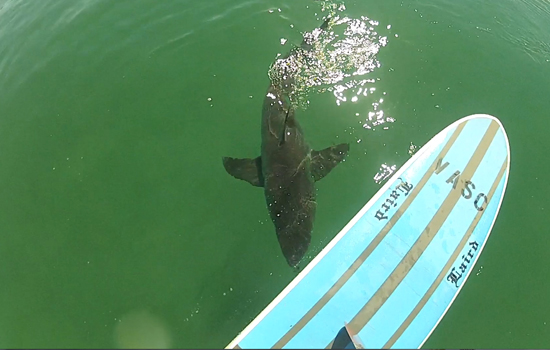
 If you haven’t seen the Video of the Great White Shark encounter, at El Porto, from 10-16-13
Check it out!
______________________________________________________________________________
For Sunday morning that NW ground swell should fill in through the day from a liberal 275-290 degree angle which means any spot that gets a whiff of Westerly swell should be in play. Most breaks will see chest to head high sets while stand out beaches see overhead sets by days end. Due to the long period nature of this energy the reefs and points will be the best bet as the beaches haven’t seen enough rain, or that one macking swell, to enable the creation of sand bars.
Sunday
2013-12-22 Sun 12:43 AM 3.82 feet High Tide
2013-12-22 Sun 05:32 AM 2.67 feet Low Tide
2013-12-22 Sun 06:56 AM Sunrise
2013-12-22 Sun 10:07 AM Moonset
2013-12-22 Sun 11:12 AM 4.50 feet High Tide
2013-12-22 Sun 04:49 PM Sunset
2013-12-22 Sun 06:24 PM 0.59 feet Low Tide
2013-12-22 Sun 09:53 PM Moonrise
2013-12-17 Tue 10:13 PM 3.81 feet High Tide
The conditions look good again with 1-3 MPH winds, out of the E/NE until noon and timid 4-5 MPH breezes out of the West in the afternoon. The air temp will top out at 67 degrees.
______________________________________________________________________________
For Monday morning that swell will ease only slightly with the top West facing beaches remaining in the head high to overhead zone. There will still be plenty of power, size and consistency for top spots but the beach breaks will likely remain on the walled side as there are no real sand bars yet. Points and reefs should be firing. It might be worth a trek to San Diego or even Northern Baja , (if you’re feeling lucky).
Monday
2013-12-23 Mon 01:30 AM 3.92 feet High Tide
2013-12-23 Mon 06:42 AM 2.72 feet Low Tide
2013-12-23 Mon 06:56 AM Sunrise
2013-12-23 Mon 10:39 AM Moonset
2013-12-23 Mon 11:59 AM 3.97 feet High Tide
2013-12-23 Mon 04:50 PM Sunset
2013-12-23 Mon 07:03 PM 0.94 feet Low Tide
2013-12-23 Mon 10:48 PM Moonrise
The conditions look excellent with NNE breezes in the 5-9 MPH until noon and timid 4-8 MPH West winds in the afternoon. The air temp tops out at a comfortable 70 degrees.
______________________________________________________________________________
Tuesday morning, (Christmas Eve), will be a bit smaller and less consistent, but nothing to sneeze at, as the solid surf continues to track into the West facing beaches. Once again the top West facing breaks will get the motherlode of energy with sets in the chest to hopefully head high zone. I’ll be better able to put a finger on it in the near future.
Tuesday
2013-12-24 Tue 02:19 AM 4.10 feet High Tide
2013-12-24 Tue 06:57 AM Sunrise
2013-12-24 Tue 08:16 AM 2.58 feet Low Tide
2013-12-24 Tue 11:10 AM Moonset
2013-12-24 Tue 01:08 PM 3.43 feet High Tide
2013-12-24 Tue 04:50 PM Sunset
2013-12-24 Tue 07:47 PM 1.28 feet Low Tide
2013-12-24 Tue 11:44 PM Moonrise
The conditions will remain fantastic with NNE breezes in the 4-7 MPH until noon and 6-8 MPH West winds in the afternoon. The air temp tops out at a 69 degrees.
______________________________________________________________________________
The current water temps Newport 60 degrees, Huntington 60 degrees, the South Bay showed as 60 degrees, Santa Monica 60 degrees and Malibu 60 degrees.
______________________________________________________________________________
I’ll be back on Sunday with the next update!
______________________________________________________________________________
