______________________________________________________________________________
[easyrotator]erc_29_1354816388[/easyrotator]
Today’s Slideshow is courtesy of Jeff Bell – The South Bay Archives – If you see a shot you like contact Jeff directly at [email protected]
______________________________________________________________________________
SOUTHERN CALIFORNIA SURF FORECAST UPDATED 2-9-14
______________________________________________________________________________
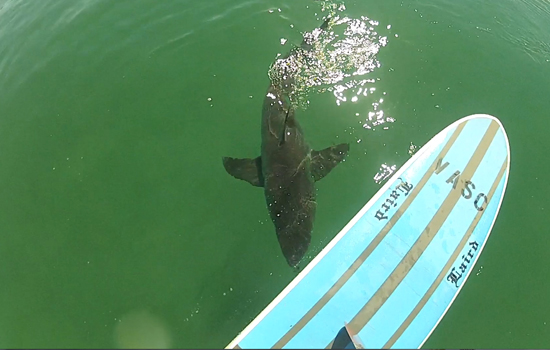
 If you haven’t seen the Video of the Great White Shark encounter, at El Porto, from 10-16-13
Check it out!
______________________________________________________________________________
For Monday morning we’ll see a similar scenario with a slight boost in wind swell. The best spots should go waist to chest high. The tide starts off a bit high at 6:21AM but recedes quickly after that.
Monday
2014-02-10 Mon 12:12 AM 2.21 feet Low Tide
2014-02-10 Mon 03:36 AM Moonset
2014-02-10 Mon 06:21 AM 5.15 feet High Tide
2014-02-10 Mon 06:43 AM Sunrise
2014-02-10 Mon 01:35 PM -0.18 feet Low Tide
2014-02-10 Mon 02:10 PM Moonrise
2014-02-10 Mon 05:33 PM Sunset
2014-02-10 Mon 08:04 PM 3.67 feet High Tide
The conditions should be fair with variable winds in the 1-6 MPH range until 1PM and 8-10 MPH in the afternoon. The air temp tops out at 67 degrees.
______________________________________________________________________________
For Tuesday morning we’ll dip back into the waist high plus range with 8-10 second interval energy out of the NW.
Tuesday
2014-02-11 Tue 12:54 AM 2.01 feet Low Tide
2014-02-11 Tue 04:19 AM Moonset
2014-02-11 Tue 06:42 AM Sunrise
2014-02-11 Tue 06:59 AM 5.32 feet High Tide
2014-02-11 Tue 02:04 PM -0.32 feet Low Tide
2014-02-11 Tue 03:02 PM Moonrise
2014-02-11 Tue 05:34 PM Sunset
2014-02-11 Tue 08:29 PM 3.83 feet High Tide
The conditions look good with 3-6 MPH winds out of NE/NNE until 11AM and 8-10 MPH Westerly breezes until Sundown. The air temp tops out at 70 degrees.
______________________________________________________________________________
Wednesday morning should be okay with waist high plus surf for the best West facing breaks, but a super high tide at 7:32AM will definitely weaken the small the lines coming in through the prime time morning surf hours.
Wednesday
2014-02-12 Wed 01:28 AM 1.79 feet Low Tide
2014-02-12 Wed 04:59 AM Moonset
2014-02-12 Wed 06:41 AM Sunrise
2014-02-12 Wed 07:32 AM 5.45 feet High Tide
2014-02-12 Wed 02:30 PM -0.40 feet Low Tide
2014-02-12 Wed 03:55 PM Moonrise
2014-02-12 Wed 05:35 PM Sunset
2014-02-12 Wed 08:51 PM 3.99 feet High Tide
The conditions look decent early with NE/NNE breezes in the 5-8 MPH zone until noon and then 10-13 MPH out of the West in the afternoon. The air temp tops out at 72 degrees.
______________________________________________________________________________
Thursday morning should go waist to chest high at the exposed West facing breaks with 8-10 second interval swell continuing from a 285 degree angle.
Thursday
2014-02-13 Thu 02:00 AM 1.58 feet Low Tide
2014-02-13 Thu 05:36 AM Moonset
2014-02-13 Thu 06:40 AM Sunrise
2014-02-13 Thu 08:04 AM 5.51 feet High Tide
2014-02-13 Thu 02:54 PM -0.41 feet Low Tide
2014-02-13 Thu 04:48 PM Moonrise
2014-02-13 Thu 05:36 PM Sunset
2014-02-13 Thu 09:13 PM 4.13 feet High Tide
The conditions look okay with light and variable breezes in the 3-7 MPH zone until 11AM and then 10-12 MPH out of the West in the afternoon. The air temp tops out at 71 degrees.
______________________________________________________________________________
The current water temps Newport 58 degrees, Huntington 59 degrees, the South Bay showed as 59 degrees, Santa Monica 59 degrees and Malibu 58 degrees.
______________________________________________________________________________
Had tons of problems with the site today… be back tomorrow with the 5DAY 4CAST!
______________________________________________________________________________
