______________________________________________________________________________
[easyrotator]erc_51_1389396068[/easyrotator]
Today’s Slideshow is courtesy of Ruben Pina – The South Bay – late 2013 – If you see a photo you like you can contact Ruben directly at [email protected] to buy a hi-res version for the wall!
______________________________________________________________________________
SOUTHERN CALIFORNIA SURF FORECAST UPDATED 1-12-14
______________________________________________________________________________
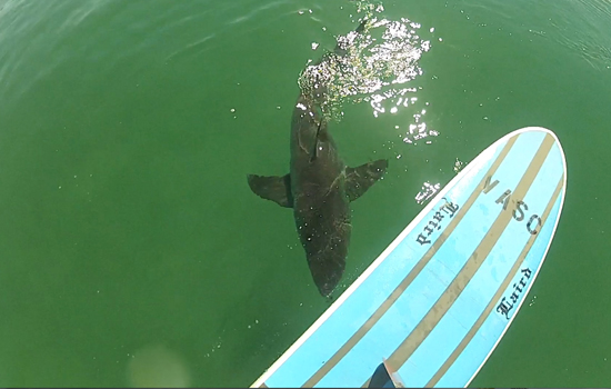
 If you haven’t seen the Video of the Great White Shark encounter, at El Porto, from 10-16-13
Check it out!
______________________________________________________________________________
For Monday morning we’ll see, (maybe), some fresh, 16 second interval ground swell move in from a ridiculously steep angle of 315 degrees. Due to the steep nature of this swell it will move on by the majority of breaks in So Cal but will be pumping North of Pt. Conception and down in the San Diego/No. Baja area.
Some of the local, deep water, West facing breaks will be able to pull in some sets. The top spots will go chest to head high with possibly a few, kook killer, bomber sets coming through.
There will be swell out there and the conditions will be unreal. It will just be a matter of putting yourself in the right place at the right time.
Monday
2014-01-13 Mon 12:59 AM 2.10 feet Low Tide
2014-01-13 Mon 04:52 AM Moonset
2014-01-13 Mon 06:59 AM Sunrise
2014-01-13 Mon 07:12 AM 5.76 feet High Tide
2014-01-13 Mon 02:26 PM -0.49 feet Low Tide
2014-01-13 Mon 03:23 PM Moonrise
2014-01-13 Mon 05:06 PM Sunset
2014-01-13 Mon 08:53 PM 3.75 feet High Tide
The conditions will be fantastic as high pressure moves in and heats up So Cal. We’ll see stiff, NE/NNE, Santa Ana breezes in the 6-12 MPH zone all day long, (stronger below passes and canyons). The air temp jumps up to 75 degrees.
______________________________________________________________________________
Tuesday morning looks to be a smaller version of Monday with that steep NNW swell coming down the line sideways from that brutal 315 degree angle. If I had the time I would drive down to Baja to score some good point break waves… Santa Ana winds continue to promote all day offshore conditions.
Tuesday
2014-01-14 Tue 01:35 AM 2.04 feet Low Tide
2014-01-14 Tue 05:38 AM Moonset
2014-01-14 Tue 06:59 AM Sunrise
2014-01-14 Tue 07:45 AM 5.82 feet High Tide
2014-01-14 Tue 02:54 PM -0.56 feet Low Tide
2014-01-14 Tue 04:14 PM Moonrise
2014-01-14 Tue 05:07 PM Sunset
2014-01-14 Tue 09:21 PM 3.83 feet High Tide
The conditions will remain excellent with continued NE/NNE breezes in the 5-15 MPH zone all day long, (stronger below passes and canyons). The air temp tops out at a 77 degrees.
______________________________________________________________________________
For Wednesday morning things will be smaller with inconsistent waist to possibly chest high sets at the top spots. The good news is that some new, but still steep, 305-310 degree ground swell will start filling in late in the day and should be in play for Thursday morning.
Wednesday
2014-01-15 Wed 02:08 AM 1.96 feet Low Tide
2014-01-15 Wed 06:21 AM Moonset
2014-01-15 Wed 06:59 AM Sunrise
2014-01-15 Wed 08:16 AM 5.82 feet High Tide
2014-01-15 Wed 03:22 PM -0.56 feet Low Tide
2014-01-15 Wed 05:07 PM Moonrise
2014-01-15 Wed 05:08 PM Sunset
2014-01-15 Wed 08:53 PM Full Moon
2014-01-15 Wed 09:48 PM 3.90 feet High Tide
The conditions will be stellar for the AM with NE/NNE breezes in the 7-15 MPH zone until noon, (stronger below passes and canyons), and 6-8 MPH West winds in the afternoon. The air temp tops out at a toasty 80 degrees.
______________________________________________________________________________
For Thursday morning the top West facing breaks should go chest to shoulder high on the sets. Once again, due to the steep nature of this swell, it will completely bypass all but the most exposed West facing beaches.
Thursday
2014-01-16 Thu 02:41 AM 1.90 feet Low Tide
2014-01-16 Thu 06:58 AM Sunrise
2014-01-16 Thu 06:59 AM Moonset
2014-01-16 Thu 08:46 AM 5.75 feet High Tide
2014-01-16 Thu 03:48 PM -0.49 feet Low Tide
2014-01-16 Thu 05:08 PM Sunset
2014-01-16 Thu 06:00 PM Moonrise
2014-01-16 Thu 10:15 PM 3.96 feet High Tide
The conditions will be pretty good again with continued NNE breezes in the 5-10 MPH zone until noon, (stronger below passes and canyons), and 4-6 MPH West winds in the afternoon. The air temp tops out at a 80 degrees again.
______________________________________________________________________________
The current water temps Newport 58 degrees, Huntington 60 degrees, the South Bay showed as 59 degrees, Santa Monica 60 degrees and Malibu 58 degrees.
______________________________________________________________________________
I’ll be back on Monday with the next update!
______________________________________________________________________________
