______________________________________________________________________________
[easyrotator]erc_78_1386112386[/easyrotator]
Today’s Slideshow is courtesy of Dave Waters – South Bay Archives
Check out more pics
______________________________________________________________________________
SOUTHERN CALIFORNIA SURF FORECAST UPDATED 1-14-14
______________________________________________________________________________
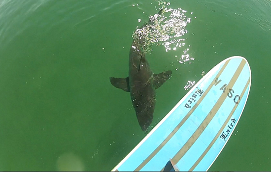
 If you haven’t seen the Video of the Great White Shark encounter, at El Porto, from 10-16-13
Check it out!
______________________________________________________________________________
It looks like we’ll finally see some solid swell roll through on the tail end of this upcoming weekend and that energy looks to carry on into early next week. Not the triple overhead, sand bar forming macker swell we were hoping for, but the better West facing beaches should see the rarely used, (this Winter), acronym, “DOH” Double Over Head.
It’s been a tough season for sure, with small, closed out, long interval swell, no rain, no sand bars, huge crowds and stellar conditions, (which makes it that much more painful)…
It’s January 14th my friends, so if something drastic doesn’t happen soon we’ll have to write off this Winter swell season and pray for a wind swelly Spring and a hot and heavy South swell summer season. I’m trying to keep my glass at least 1/4 full but I just noticed a spider web crack in the bottom.
______________________________________________________________________________
For Wednesday morning things will be smaller, with inconsistent waist to possibly chest high sets at the top spots. The good news is that some new, but still steep, 305-310 degree ground swell will start filling in late in the day and should be in play for Thursday morning.
Wednesday
2014-01-15 Wed 02:08 AM 1.96 feet Low Tide
2014-01-15 Wed 06:21 AM Moonset
2014-01-15 Wed 06:59 AM Sunrise
2014-01-15 Wed 08:16 AM 5.82 feet High Tide
2014-01-15 Wed 03:22 PM -0.56 feet Low Tide
2014-01-15 Wed 05:07 PM Moonrise
2014-01-15 Wed 05:08 PM Sunset
2014-01-15 Wed 08:53 PM Full Moon
2014-01-15 Wed 09:48 PM 3.90 feet High Tide
The conditions will be stellar for the AM, with NE/NNE breezes in the 4-15 MPH zone all day long, (stronger below passes and canyons). The air temp tops out at a toasty 78 degrees.
______________________________________________________________________________
For Thursday morning the top West facing breaks should go chest high on the sets from a steep 305 degrees. Once again, due to the steep nature of this swell, it will bypass all but the most exposed West facing beaches.
Thursday
2014-01-16 Thu 02:41 AM 1.90 feet Low Tide
2014-01-16 Thu 06:58 AM Sunrise
2014-01-16 Thu 06:59 AM Moonset
2014-01-16 Thu 08:46 AM 5.75 feet High Tide
2014-01-16 Thu 03:48 PM -0.49 feet Low Tide
2014-01-16 Thu 05:08 PM Sunset
2014-01-16 Thu 06:00 PM Moonrise
2014-01-16 Thu 10:15 PM 3.96 feet High Tide
The conditions will be pretty good again with continued NNE breezes in the 5-10 MPH zone all day, (stronger below passes and canyons). The air temp hovers at a balmy 78 degrees again.
______________________________________________________________________________
Friday morning looks to be a smaller version of Thursday with that steep NNW swell coming down the line sideways from 305 degree angle. The top spots should see waist to chest high sets.
Friday
2014-01-17 Fri 03:14 AM 1.86 feet Low Tide
2014-01-17 Fri 06:58 AM Sunrise
2014-01-17 Fri 07:35 AM Moonset
2014-01-17 Fri 09:17 AM 5.58 feet High Tide
2014-01-17 Fri 04:15 PM -0.35 feet Low Tide
2014-01-17 Fri 05:09 PM Sunset
2014-01-17 Fri 06:54 PM Moonrise
2014-01-17 Fri 10:42 PM 4.01 feet High Tide
The conditions will remain excellent for the AM with continued NE/NNE breezes in the 5-10 MPH until 11AM and mild 6-8 MPH breezes out of the West until sundown. The air temp tops out at a 79 degrees.
______________________________________________________________________________
Saturday morning will start off on the small side with waist high plus surf for the better West facing breaks, but that will be the end of the small stuff for a while, as some fresh, more Westerly, long interval ground swell starts to fill in later in the day. By Sunday morning we should see some solid lines roar in for top spots.
Saturday
2014-01-18 Sat 03:48 AM 1.87 feet Low Tide
2014-01-18 Sat 06:58 AM Sunrise
2014-01-18 Sat 08:09 AM Moonset
2014-01-18 Sat 09:48 AM 5.32 feet High Tide
2014-01-18 Sat 04:42 PM -0.14 feet Low Tide
2014-01-18 Sat 05:10 PM Sunset
2014-01-18 Sat 07:48 PM Moonrise
2014-01-18 Sat 11:12 PM 4.06 feet High Tide
The conditions will remain good with continued NE/NNE breezes in the 2-6 MPH zone until 11AM and 4-6 MPH out of the West in the afternoon. The air temp tops out at a 75 degrees.
______________________________________________________________________________
By Sunday morning the top West facing breaks, if nothing else, should have some size by first light. The top breaks should see chest to head high sets with overhead waves building in through the day. The tides look good along with the conditions. I’ll continue to track this one daily so keep checking back for the latest update!
Sunday
2014-01-19 Sun 04:26 AM 1.92 feet Low Tide
2014-01-19 Sun 06:58 AM Sunrise
2014-01-19 Sun 08:42 AM Moonset
2014-01-19 Sun 10:20 AM 4.94 feet High Tide
2014-01-19 Sun 05:10 PM 0.15 feet Low Tide
2014-01-19 Sun 05:11 PM Sunset
2014-01-19 Sun 08:42 PM Moonrise
2014-01-19 Sun 11:44 PM 4.10 feet High Tide
The conditions will remain great early with continued NE/NNE breezes in the 2-5 MPH zone until 11AM and 4-8 MPH West winds in the afternoon. The air temp tops out at a 75 degrees.
______________________________________________________________________________
The current water temps Newport 58 degrees, Huntington 60 degrees, the South Bay showed as 59 degrees, Santa Monica 60 degrees and Malibu 58 degrees.
______________________________________________________________________________
I’ll be back on Wednesday with the next update!
______________________________________________________________________________
