______________________________________________________________________________
[easyrotator]erc_17_1389908460[/easyrotator]
Today’s Slideshow is courtesy of Ruben Pina – Tyler Hatzikian and his crew scoring a few good ones! – If you see a photo you like you can contact Ruben directly at [email protected] to buy a hi-res version for the wall!
______________________________________________________________________________
SOUTHERN CALIFORNIA SURF FORECAST UPDATED 1-16-14
______________________________________________________________________________
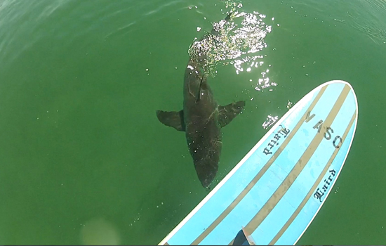
 If you haven’t seen the Video of the Great White Shark encounter, at El Porto, from 10-16-13
Check it out!
______________________________________________________________________________
FOUND Watch at El Porto
Email detailed discription and tell him where you left it and he’ll make sure you get it back.
E-mail: [email protected]
______________________________________________________________________________
Friday morning looks to be a smaller version of Thursday with that steep NNW swell coming down the line sideways from 296-305 degree angle. The top spots should see inconsistent waist high plus sets, but the high tide at 9:17AM will definitely slow things down.
Friday
2014-01-17 Fri 03:14 AM 1.86 feet Low Tide
2014-01-17 Fri 06:58 AM Sunrise
2014-01-17 Fri 07:35 AM Moonset
2014-01-17 Fri 09:17 AM 5.58 feet High Tide
2014-01-17 Fri 04:15 PM -0.35 feet Low Tide
2014-01-17 Fri 05:09 PM Sunset
2014-01-17 Fri 06:54 PM Moonrise
2014-01-17 Fri 10:42 PM 4.01 feet High Tide
The conditions will remain excellent for the AM with continued NE/NNE breezes in the 2-12 MPH until 11AM and mild 3-6 MPH breezes out of the West until sundown. The air temp tops out at a 80 degrees.
______________________________________________________________________________
Saturday morning will start off on the small side with waist to chest high surf for the better West facing breaks, but that will be the end of the little stuff for a while, as some fresh, more Westerly, long interval, ground swell fills in throughout the day. By Sunday morning we should see some solid lines roar in for top spots.
Saturday
2014-01-18 Sat 03:48 AM 1.87 feet Low Tide
2014-01-18 Sat 06:58 AM Sunrise
2014-01-18 Sat 08:09 AM Moonset
2014-01-18 Sat 09:48 AM 5.32 feet High Tide
2014-01-18 Sat 04:42 PM -0.14 feet Low Tide
2014-01-18 Sat 05:10 PM Sunset
2014-01-18 Sat 07:48 PM Moonrise
2014-01-18 Sat 11:12 PM 4.06 feet High Tide
The conditions will remain good with variable breezes out of the East in the 2-6 MPH zone until 11AM and 4-6 MPH out of the West in the afternoon. The air temp tops out at a 78 degrees.
______________________________________________________________________________
By Sunday morning the top West facing breaks, if nothing else, should have some size by first light. The top breaks should see chest to head high sets with overhead waves building in through the day. The tides look good for the AM, along with the conditions. All of this new swell will have more West in it than the last few we’ve seen. This should, hopefully, spread out the crowds a bit as there will be many more options out there.
Sunday
2014-01-19 Sun 04:26 AM 1.92 feet Low Tide
2014-01-19 Sun 06:58 AM Sunrise
2014-01-19 Sun 08:42 AM Moonset
2014-01-19 Sun 10:20 AM 4.94 feet High Tide
2014-01-19 Sun 05:10 PM 0.15 feet Low Tide
2014-01-19 Sun 05:11 PM Sunset
2014-01-19 Sun 08:42 PM Moonrise
2014-01-19 Sun 11:44 PM 4.10 feet High Tide
The conditions will remain great early, with continued E/NE breezes in the 2-5 MPH zone until 11AM and 6-8 MPH West winds in the afternoon. The air temp tops out at 75 degrees.
______________________________________________________________________________
For Monday morning the NW energy will be pulsing in all day and put the top, deep water, West facing beaches into the well overhead zone while the average breaks see shoulder to head high sets. Long intervals and a more Westerly angle should open the doors to all of the reefs and points up and down the coast. Once again, not a wave bonanza, but when you toss a starving man a piece of stale bread it still tastes pretty damn good.
Monday
2014-01-20 Mon 05:10 AM 1.99 feet Low Tide
2014-01-20 Mon 06:57 AM Sunrise
2014-01-20 Mon 09:13 AM Moonset
2014-01-20 Mon 10:55 AM 4.47 feet High Tide
2014-01-20 Mon 05:12 PM Sunset
2014-01-20 Mon 05:38 PM 0.49 feet Low Tide
2014-01-20 Mon 09:37 PM Moonrise
The conditions will be good again for the AM, with NE/NNE breezes in the 1-4 MPH zone until 11AM and 4-6 MPH out of the West in the afternoon. The air temp tops out at 75 degrees.
______________________________________________________________________________
For Tuesday morning the top West facing breaks should go head high plus on the sets in the early AM and a new NW swell will overlap and build in through the day. By days end we should be back into the overhead zone for the top West facing beaches.
Tuesday
2014-01-21 Tue 12:20 AM 4.16 feet High Tide
2014-01-21 Tue 06:04 AM 2.04 feet Low Tide
2014-01-21 Tue 06:57 AM Sunrise
2014-01-21 Tue 09:45 AM Moonset
2014-01-21 Tue 11:37 AM 3.93 feet High Tide
2014-01-21 Tue 05:13 PM Sunset
2014-01-21 Tue 06:09 PM 0.89 feet Low Tide
2014-01-21 Tue 10:34 PM Moonrise
The conditions will be pretty good again with continued NE/NNE breezes in the 1-4 MPH zone until 11AM and 3-9 MPH, out of the West in the afternoon. The air temp jumps back up to a toasty 79 degrees again.
______________________________________________________________________________
The current water temps Newport 60 degrees, Huntington 60 degrees, the South Bay showed as 59 degrees, Santa Monica 60 degrees and Malibu 59 degrees.
______________________________________________________________________________
I’ll be back on Friday with the next update!
______________________________________________________________________________
