______________________________________________________________________________
[easyrotator]erc_86_1390934069[/easyrotator]
Today’s Slideshow is courtesy of Jeff Bell – The South Bay – January 25-27 2014 If you see a shot you like contact Jeff directly at [email protected]
______________________________________________________________________________
SOUTHERN CALIFORNIA SURF FORECAST UPDATED 1-31-14
______________________________________________________________________________
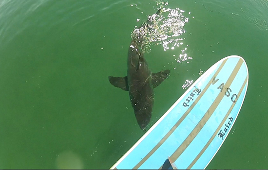
 If you haven’t seen the Video of the Great White Shark encounter, at El Porto, from 10-16-13
Check it out!
______________________________________________________________________________
If you haven’t already done so please become a fan of our Facebook page. We’re constantly featuring new videos and following all the latest news on Lunada Bay Reclamation Project, (Looks like it’s all over for the Bay Boys in PV. Lunada has been declared Aloha Point and everyone and there brother is urged to head down there!)
Get details here and be sure to give us a like!

______________________________________________________________________________
For Sunday morning, for the first time in a long time, we’ll be hurting for waves. The better breaks will drop down into the waist high zone. There will be another little tide push through the morning, so hopefully it adds a little pop to the lackluster scenario.
Sunday
2014-02-02 Sun 04:35 AM 0.79 feet Low Tide
2014-02-02 Sun 06:50 AM Sunrise
2014-02-02 Sun 08:31 AM Moonrise
2014-02-02 Sun 10:38 AM 5.55 feet High Tide
2014-02-02 Sun 05:10 PM -0.50 feet Low Tide
2014-02-02 Sun 05:25 PM Sunset
2014-02-02 Sun 09:02 PM Moonset
2014-02-02 Sun 11:34 PM 5.07 feet High Tide
The conditions should be okay with variable winds out of the East in the 3-6 MPH range until 11AM and 6-8 MPH in the afternoon. The air temp dips down to 61 degrees.
______________________________________________________________________________
Monday morning doesn’t look quite as bleak as originally forecasted. We should see a combination of NW wind swell and some steeply angled, medium interval, NW energy. The best West facing breaks that can handle a 300 + degree angle should go waist high plus with the chance of some chest high sets.
Monday
2014-02-03 Mon 05:33 AM 0.92 feet Low Tide
2014-02-03 Mon 06:49 AM Sunrise
2014-02-03 Mon 09:09 AM Moonrise
2014-02-03 Mon 11:29 AM 4.75 feet High Tide
2014-02-03 Mon 05:26 PM Sunset
2014-02-03 Mon 05:50 PM 0.16 feet Low Tide
2014-02-03 Mon 10:06 PM Moonset
The conditions look okay with light and variable breezes in the 3-6 MPH zone until 11AM and then 10-15 MPH out of the West in the afternoon. The air temp tops out at 62 degrees.
______________________________________________________________________________
For Tuesday morning that steeply angled, NW swell will funnel in some medium interval waist to chest high sets for the most exposed West facing beaches.
Tuesday
2014-02-04 Tue 12:21 AM 5.01 feet High Tide
2014-02-04 Tue 06:39 AM 1.10 feet Low Tide
2014-02-04 Tue 06:48 AM Sunrise
2014-02-04 Tue 09:47 AM Moonrise
2014-02-04 Tue 12:29 PM 3.91 feet High Tide
2014-02-04 Tue 05:27 PM Sunset
2014-02-04 Tue 06:32 PM 0.85 feet Low Tide
2014-02-04 Tue 11:08 PM Moonset
The conditions look pretty good early with North Easterly breezes in the 5-8 MPH zone until 11AM and then 8-10 MPH out of the West in the afternoon. The air temp tops out at 64 degrees again.
______________________________________________________________________________
The current water temps Newport 61 degrees, Huntington 61 degrees, the South Bay showed as 60 degrees, Santa Monica 60 degrees and Malibu 60 degrees.
______________________________________________________________________________
I’ll be back on SuperBowl Sunday with the next update!
______________________________________________________________________________
