______________________________________________________________________________
SOUTHERN CALIFORNIA SURF FORECAST UPDATED 3-10-16
______________________________________________________________________________
If anyone is still having problems getting the streams please try the “Chrome Browser” for now. We are still trying to iron out a few kinks! Android users that are having problems will need to download the “Puffin Browser”. Feel free to email us for technical support contact us
______________________________________________________________________________
For Friday morning we’ll start off with shoulder to head high sets from that same angle. The top West facing breaks will definitely have the most action for the morning, but another round of beefy swell will be arriving right on its heels, so look for a substantial jump in size on Saturday morning.
Friday
2016-03-11 Fri 04:40 AM -0.10 feet Low Tide
2016-03-11 Fri 06:09 AM Sunrise
2016-03-11 Fri 08:02 AM Moonrise
2016-03-11 Fri 10:47 AM 4.90 feet High Tide
2016-03-11 Fri 04:48 PM 0.23 feet Low Tide
2016-03-11 Fri 05:59 PM Sunset
2016-03-11 Fri 09:18 PM Moonset
2016-03-11 Fri 11:06 PM 5.52 feet High Tide
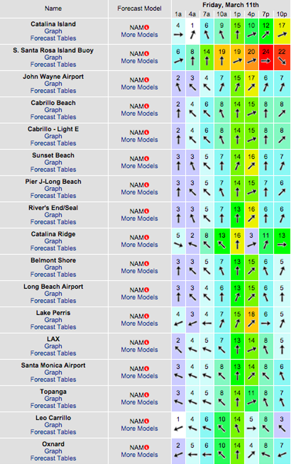
The conditions start off okay early with 4-8 MPH breezes out of the E/SE until around noon, but that doesn’t last long, with double digit onshore gusts whipping up shortly after that and increasing up to as high as 17 MPH in some locations.There is a 100% chance of rain, (which is not slated to start until around 2:00PM) and along with it lightning and thunder. The air temp dips to 64 degrees.

______________________________________________________________________________
Saturday morning looks like another significant swell with OH +, (to possible DOH at the top deep water West facing beaches). This energy looks to be pretty consistent with 12-14 second intervals from a Westerly, 270-290 degree angle. The waves will likely be a bit jumbled and chaotic so definitely look before you leap.
* Be advised, if it rains hard on Friday, that 72 stay out of the water, (dodging Urban Runoff and the super bug rule), comes into play.
Saturday
2016-03-12 Sat 05:36 AM -0.00 feet Low Tide
2016-03-12 Sat 06:07 AM Sunrise
2016-03-12 Sat 08:46 AM Moonrise
2016-03-12 Sat 11:45 AM 4.22 feet High Tide
2016-03-12 Sat 05:30 PM 0.84 feet Low Tide
2016-03-12 Sat 05:59 PM Sunset
2016-03-12 Sat 10:25 PM Moonset
2016-03-12 Sat 11:53 PM 5.37 feet High Tide
The conditions could go either way for the AM. The sea surface will be hard pressed to smooth out overnight with all of the winds on Friday… but I’ve seen stranger things happen. On paper, we have variable 2-4 MPH winds early and those increase to 8-11 MPH in the afternoon. There is only a 10% chance of rain and the air temp holds steady at 64 degrees.
______________________________________________________________________________
Sunday morning looks a bit smaller, but there will still be plenty of “PUMP” out there with OH + surf for the best West facing beaches. The direction will remain 270 + degrees and the intervals will drop to 12 seconds.
Sunday
2016-03-13 Sun 07:06 AM Sunrise
2016-03-13 Sun 07:43 AM 0.19 feet Low Tide
2016-03-13 Sun 10:33 AM Moonrise
2016-03-13 Sun 01:57 PM 3.58 feet High Tide
2016-03-13 Sun 07:00 PM Sunset
2016-03-13 Sun 07:18 PM 1.47 feet Low Tide
The conditions look okay early with light and variable winds at 2-5 MPH until noon and then 13-21 MPH out of the West in the afternoon. There is a 10% chance of rain and air temp tops out at 64 degrees.
______________________________________________________________________________
For Monday morning the swell will continue to drop in the AM, but there will still be plenty of waves as the better West facing breaks continue to produce shoulder to head high surf.
It looks like we’ll see some fresh ground swell start to work its way into the fold mid day/to later in the afternoon. This energy will be a bit steeper and stronger than the last swell as it moves down the line at a 295-305 degree angle with 14-16 + second intervals.
Monday
2016-03-14 Mon 12:30 AM Moonset
2016-03-14 Mon 01:49 AM 5.12 feet High Tide
2016-03-14 Mon 07:05 AM Sunrise
2016-03-14 Mon 09:05 AM 0.34 feet Low Tide
2016-03-14 Mon 11:22 AM Moonrise
2016-03-14 Mon 03:37 PM 3.17 feet High Tide
2016-03-14 Mon 07:01 PM Sunset
2016-03-14 Mon 08:25 PM 2.02 feet Low Tide
The conditions will likely be a bit compromised, with 2-7 MPH winds out of the West until noon and then those jump up to 9-12 MPH after that. There’s a 30% chance of rain and the air temp tops out at 63 degrees.
______________________________________________________________________________
For Tuesday morning the swell will peak and produce overhead + surf from that same 295-305 degree angle with 16 second intervals.
Tuesday
2016-03-15 Tue 01:30 AM Moonset
2016-03-15 Tue 03:00 AM 4.86 feet High Tide
2016-03-15 Tue 07:03 AM Sunrise
2016-03-15 Tue 10:04 AM First Quarter
2016-03-15 Tue 10:39 AM 0.30 feet Low Tide
2016-03-15 Tue 12:14 PM Moonrise
2016-03-15 Tue 05:33 PM 3.21 feet High Tide
2016-03-15 Tue 07:02 PM Sunset
2016-03-15 Tue 10:04 PM 2.33 feet Low Tide
The conditions look mediocre at best with Westerly winds at 3-10 MPH all day long. The air temp tops out at 66 degrees.
______________________________________________________________________________
Water Temps: are as follows – Malibu 57, Santa Monica 60, Hermosa 62, Huntington 60 & Newport 60 degrees.
______________________________________________________________________________
I’ll be back on Friday with the next update!
______________________________________________________________________________
