______________________________________________________________________________
[easyrotator]erc_47_1353523463[/easyrotator]
Today’s Slideshow is courtesy of Dave Waters – The South Bay Archives Check out more pics
______________________________________________________________________________
SOUTHERN CALIFORNIA SURF FORECAST UPDATED 11-21-13
______________________________________________________________________________
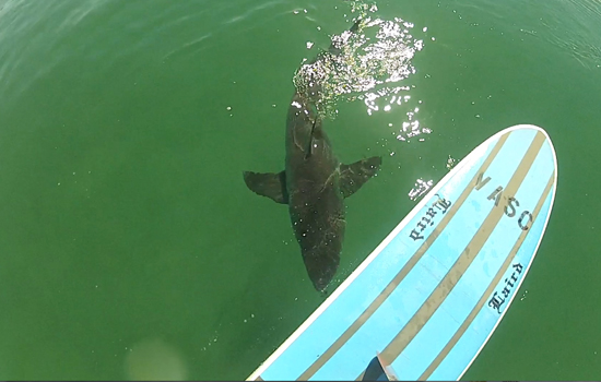
 If you haven’t seen the Video of the Great White Shark encounter, at El Porto, from 10-16-13
Check it out!
______________________________________________________________________________
HURRICANE WATCH 11-21-13
The Eastern Pacific Basin is expected to remain quiet for at least the next couple of days.
______________________________________________________________________________
Wow… I don’t think I’ve ever seen such a poor November for waves! Usually you can at least bank on a cranking swell for Thanksgiving, (especially if I’m land locked somewhere else on Turkey Day), but no such luck this year! It looks like we’ll finish out the month with continued anemic surf and only a dulled glimmer of light at the end of the tunnel.
Hopefully Mother Nature gets out of Rehab soon and back into the work force. She’s definitely been asleep at the wheel over the last couple of months! Keep your fingers crossed that we get rewarded in December!!!
______________________________________________________________________________
For Friday morning should see a minor uptick in energy with the better West facing beaches seeing waist high surf. The conditions look unreal with all day offshore winds… we just need a decent burst of swell!!!
*To add insult to injury we got quite a bit more rain than I thought we would and that will result in the dreaded “Urban Runoff Syndrome”. This being the first decent rain storm in a long time, we anticipate extremely dirty water as all outlets to sea are flushed of every toxin known to man, and into our beloved Pacific Ocean. Do yourself a favor and stay out of the water for 72 hours, (which shouldn’t be hard with the current state of affairs), and if you are going in, at the very least, use some ear plugs and rinse off quickly after exiting the water.
Friday
2013-11-22 Fri 12:52 AM 3.57 feet High Tide
2013-11-22 Fri 04:53 AM 2.97 feet Low Tide
2013-11-22 Fri 06:33 AM Sunrise
2013-11-22 Fri 10:22 AM Moonset
2013-11-22 Fri 10:56 AM 4.89 feet High Tide
2013-11-22 Fri 04:46 PM Sunset
2013-11-22 Fri 06:35 PM 0.61 feet Low Tide
2013-11-22 Fri 09:19 PM Moonrise
The conditions look excellent with stiff offshore winds in the in the 5-20 MPH range all day long, (stronger below the passes and canyons). There’s a 30% chance of rain and the air temp will warm up to 68 degrees.
______________________________________________________________________________
Saturday morning looks to be a hair smaller with feeble knee to maybe West high sets but the conditions will remain good.
Saturday
2013-11-23 Sat 01:59 AM 3.62 feet High Tide
2013-11-23 Sat 05:58 AM 3.14 feet Low Tide
2013-11-23 Sat 06:34 AM Sunrise
2013-11-23 Sat 10:59 AM Moonset
2013-11-23 Sat 11:43 AM 4.44 feet High Tide
2013-11-23 Sat 04:46 PM Sunset
2013-11-23 Sat 07:26 PM 0.88 feet Low Tide
2013-11-23 Sat 10:13 PM Moonrise
The conditions will remain fair with offshore winds at 3-14 MPH all day. There’s a 10% chance of rain and the air temp will top out at 66 degrees.
______________________________________________________________________________
For Sunday morning the best spots will see knee high surf most everywhere.
Sunday
2013-11-24 Sun 03:04 AM 3.79 feet High Tide
2013-11-24 Sun 06:35 AM Sunrise
2013-11-24 Sun 07:42 AM 3.17 feet Low Tide
2013-11-24 Sun 11:33 AM Moonset
2013-11-24 Sun 12:47 PM 3.98 feet High Tide
2013-11-24 Sun 04:46 PM Sunset
2013-11-24 Sun 08:21 PM 1.10 feet Low Tide
2013-11-24 Sun 11:07 PM Moonrise
The conditions will remain fair with 5-9 MPH offshore winds until 11AM and 8-10 MPH breezes out of the West in the afternoon. The air temp will top out at 66 degrees
______________________________________________________________________________
Monday morning we’ll see continued knee high surf at the best West facing breaks.
Monday
2013-11-25 Mon 03:54 AM 4.05 feet High Tide
2013-11-25 Mon 06:36 AM Sunrise
2013-11-25 Mon 09:32 AM 2.88 feet Low Tide
2013-11-25 Mon 11:30 AM Last Quarter
2013-11-25 Mon 12:06 PM Moonset
2013-11-25 Mon 02:19 PM 3.63 feet High Tide
2013-11-25 Mon 04:45 PM Sunset
2013-11-25 Mon 09:15 PM 1.28 feet Low Tide
The conditions look okay with NE winds in the 3-6 MPH range until 11AM and 8-10 MPH breezes out of the West in the afternoon. The air temp will top out at 66 degrees.
______________________________________________________________________________
For Tuesday morning morning we’ll see continued knee high surf at the best West facing breaks.
Tuesday
2013-11-26 Tue 12:02 AM Moonrise
2013-11-26 Tue 04:31 AM 4.39 feet High Tide
2013-11-26 Tue 06:37 AM Sunrise
2013-11-26 Tue 10:47 AM 2.34 feet Low Tide
2013-11-26 Tue 12:38 PM Moonset
2013-11-26 Tue 03:53 PM 3.50 feet High Tide
2013-11-26 Tue 04:45 PM Sunset
2013-11-26 Tue 10:05 PM 1.41 feet Low Tide
The conditions look a little iffy with N/NE winds in the 3-7 MPH until 11AM and 6-9 MPH onshores in the afternoon. The air temp will top out at 68 degrees.
______________________________________________________________________________
The current water temps Newport 63 degrees, Huntington 63 degrees, the South Bay showed as 63 degrees, Santa Monica 63 degrees and Malibu 62 degrees.
______________________________________________________________________________
I’ll be back on Friday with the next update!
______________________________________________________________________________
