_______________________________________________________________________________________________________
SOUTHERN CALIFORNIA SURF FORECAST UPDATED on December – 19th – 2019
______________________________________________________________________________________________________
For Friday morning the surf will slow down a hair but continue to generate head high to OH sets for the better West facing breaks. The fading swell will continue from 295-305 degrees with 13 second intervals and later in the day we will see another beefy round of waves roll into town from another steep angle of 305 degrees with meaty 19 second intervals. Saturday morning should be pretty solid!
Friday
2019-12-20 Fri 12:59 AM Moonrise
2019-12-20 Fri 04:40 AM 5.17 feet High Tide
2019-12-20 Fri 06:54 AM Sunrise
2019-12-20 Fri 11:12 AM 1.31 feet Low Tide
2019-12-20 Fri 01:12 PM Moonset
2019-12-20 Fri 04:48 PM Sunset
2019-12-20 Fri 04:49 PM 3.79 feet High Tide
2019-12-20 Fri 10:39 PM 0.99 feet Low Tide
The conditionslook great again with 2-7 MPH winds out of the NE/NNE until 2:00PM, (slightly stronger below passes and canyons), and a timid 2-3 MPH out of the NW in the afternoon. The air temp bumps up to 72 degrees.
______________________________________________________________________________________________________
On Saturday morning the surf will be solid with OH to WOH sets at the top West facing beaches as that aforementioned swell hits full stride by the morning. This energy will move in from a 300-305 degree angle with powerful 17-18 second intervals.
The higher tides will start working their way into the equation for the early bird sessions as well.
Saturday
2019-12-21 Sat 02:05 AM Moonrise
2019-12-21 Sat 05:23 AM 5.66 feet High Tide
2019-12-21 Sat 06:55 AM Sunrise
2019-12-21 Sat 12:12 PM 0.51 feet Low Tide
2019-12-21 Sat 01:46 PM Moonset
2019-12-21 Sat 04:48 PM Sunset
2019-12-21 Sat 06:06 PM 3.78 feet High Tide
2019-12-21 Sat 11:29 PM 1.27 feet Low Tide
The conditionslook fantastic with 2-5 MPH winds out of the East all day long, (slightly stronger below passes and canyons). The air temp tops out at 70 degrees.
______________________________________________________________________________________________________
For Sunday morning the surf will slow down a hair but that same swell will continue to generate head high to OH sets for the better West facing breaks from 300-305 degrees with 14 second intervals.
* Pretty fat tide right around 6:00 AM!
Sunday
2019-12-22 Sun 03:11 AM Moonrise
2019-12-22 Sun 06:03 AM 6.08 feet High Tide
2019-12-22 Sun 06:55 AM Sunrise
2019-12-22 Sun 01:02 PM -0.20 feet Low Tide
2019-12-22 Sun 02:23 PM Moonset
2019-12-22 Sun 04:49 PM Sunset
2019-12-22 Sun 07:11 PM 3.85 feet High Tide
The conditionslook great for spots that can handle a Southerly wind. We’ll see 6-11 MPH winds out of the SE/SSE all day long The air temp dips to 63 degrees and there’s a 40% chance of rain.
______________________________________________________________________________________________________
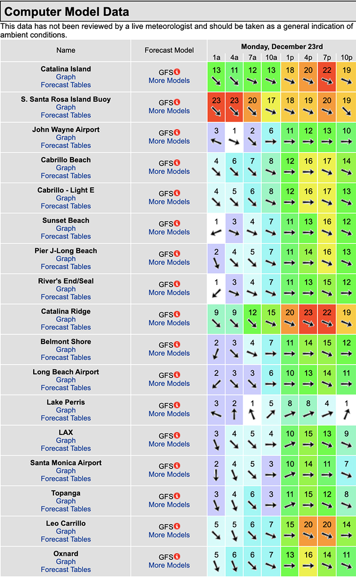
On Monday the 13th the surf will continue to fade but dish up shoulder to head high + surf from 300-305 degrees and 13 second intervals. It looks like the weather may take a turn for the worse so go in with managed expectations.
Monday
2019-12-23 Mon 12:15 AM 1.52 feet Low Tide
2019-12-23 Mon 04:17 AM Moonrise
2019-12-23 Mon 06:42 AM 6.40 feet High Tide
2019-12-23 Mon 06:56 AM Sunrise
2019-12-23 Mon 01:48 PM -0.74 feet Low Tide
2019-12-23 Mon 03:03 PM Moonset
2019-12-23 Mon 04:49 PM Sunset
2019-12-23 Mon 08:06 PM 3.91 feet High Tide
The conditions look iffy with all day onshore winds, (see below). The air temp dips to 57 degrees and there’s a 60% chance of rain.

______________________________________________________________________________________________________
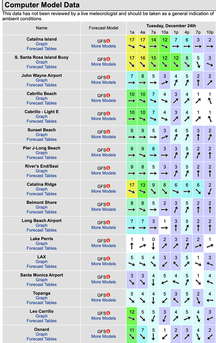
On Tuesday morning the surf will check in around shoulder high + but crummy weather remains a concern.
Tuesday
2019-12-24 Tue 12:58 AM 1.73 feet Low Tide
2019-12-24 Tue 05:22 AM Moonrise
2019-12-24 Tue 06:56 AM Sunrise
2019-12-24 Tue 07:20 AM 6.58 feet High Tide
2019-12-24 Tue 02:31 PM -1.07 feet Low Tide
2019-12-24 Tue 03:47 PM Moonset
2019-12-24 Tue 04:50 PM Sunset
2019-12-24 Tue 08:55 PM 3.95 feet High Tide
The conditionsiffy again. The air temp tops out at 68 degrees and there’s a 20% chance of rain.

______________________________________________________________________________________________________
Water temps are as follows, (day of 4CAST update), Malibu 59 Santa Monica 58 South Bay 58, Huntington 57, Newport 60.
______________________________________________________________________________________________________
The next 4Cast will be updated on Friday!
______________________________________________________________________________________________________
ABOUT THE SWELLMAGNET FORECAST – One of the most exciting–and yet most challenging–aspects of surfing is the sheer variety of waves and weather conditions that affect the entire surfing experience. Any surfer who is interested in going beyond the most basic level of surfing will have to develop the ability to interpret waves and environmental conditions. This is important for ensuring both a safe and enjoyable experience.
The main difficulty lies in predicting how exactly the ocean and the environment will behave at any given time. One day, you could be riding four-footers all day and the next, you might be facing a glasslike surface with nary a ripple. Conditions can change drastically from day-to-day and even within the space of a couple of hours. To avoid wasted time and unproductive trips to the surf, it is essential to have access to reliable information on surf conditions.
Sites such as Swellmagnet.com offer up-to-the-minute surf reports that are essential to all California surfers. The company relies on an extensive network of surf cams and surf experts in order to monitor the precise surf conditions on any given day. All information is collated and analyzed by qualified surf specialists, with the resulting data being provided to the public via the Swellmagnet site.
Swellmagnet provides some of the best surf reports in the industry, with accurate and verifiable results gathered via an innovative system of surf condition monitors and detectors. Expert surf analysis is provided by the company’s team of highly experienced specialists, each with long years of experience monitoring and actually experiencing the full range of surf conditions. This combination of state-of-the-art technology and extensive practical experience ensures the highest quality and most accurate surf reports available.
For surfers who wish to take full advantage of the best that the California coast has to offer, the services provided by Swellmagnet are essential.

This Surf Forecast is brought to you by Anderson Surfboards!
