_______________________________________________________________________________________________________
SOUTHERN CALIFORNIA SURF FORECAST UPDATED on 1-6-19
_______________________________________________________________________________________________________
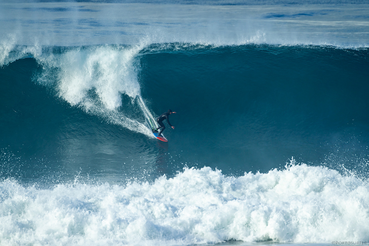
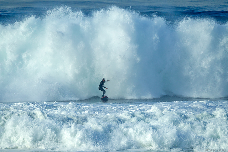
So that Swell REALLY came up today and as I’ve referenced before, it looked like “A Navy Seal Training Exercise”, that was also infused with a “building up an immunity to biological pathogens” program, ie “Urban Runoff”, from last nights “Cats and Dogs” rain storm. Anyway, I went down there early and watched some Blue Chip Surfers take a major beating and only a couple of guys were able to penetrate outside of the breaking wave zone.
As for shape… I’d say 1 out of a 100 had any legitimate corner, but it was the kind of morning that you could get the barrel of your life if you were in the right place at the right time and hit the jackpot. I opted to put my tail between my legs and live to fight another day, (just not feeling it after that long injury layoff), but my hat’s off to the guys that braved the Jumbo sized surf and toxic water! May the backwash be with you!
What can I say about this guy? Fearless Flavio… zero regard for his body and mentally as strong as an OX. Glad to call you a friend Flav! Paddling out at El Porto today was absolutely brutal!
Pretty sure this is the biggest wave ridden in the South Bay this year, (2019)! If you think otherwise… prove me wrong!
Flavio Pires – Cheating a beating once again! Wait… he lived right Lucio?
All pics by Lucio Gomes – 1-6-2019
_______________________________________________________________________________________________________
For Monday morning we’ll see a drop in size, but there will still be plenty of surf left with head high to OH + sets, (in the AM), from a 270-290 degree angle with 10-12 second intervals. The swell is slated to dissipate quickly but based on what I saw this morning… ehh… might be pretty big still!
Morning tides start to get more reasonable but remain full: 09:16 AM 5.78 feet High Tide
Beware of the Urban Runoff from Sat night – It is advised to stay out of the water for 72 hours following any measurable rainfall.
Monday
2019-01-07 Mon 03:03 AM 2.29 feet Low Tide
2019-01-07 Mon 07:00 AM Sunrise
2019-01-07 Mon 08:11 AM Moonrise
2019-01-07 Mon 09:16 AM 5.78 feet High Tide
2019-01-07 Mon 04:34 PM -0.53 feet Low Tide
2019-01-07 Mon 05:00 PM Sunset
2019-01-07 Mon 06:41 PM Moonset
2019-01-07 Mon 11:09 PM 3.67 feet High Tide
The conditions look good with variable breezes out of the East at 4-10 MPH all day long. There’s a 60% chance of AM showers and the air temp tops out at 61 degrees.
______________________________________________________________________________________________________
For Tuesday morning we’ll see another little drop in size but the West facing beaches will dish up chest to head high sets from a 280-290 degree angle with 12 second intervals.
Beware of the Urban Runoff – It is advised to stay out of the water for 72 hours following any measurable rainfall.
Tuesday
2019-01-08 Tue 03:37 AM 2.35 feet Low Tide
2019-01-08 Tue 07:00 AM Sunrise
2019-01-08 Tue 08:51 AM Moonrise
2019-01-08 Tue 09:47 AM 5.53 feet High Tide
2019-01-08 Tue 05:01 PM Sunset
2019-01-08 Tue 05:06 PM -0.30 feet Low Tide
2019-01-08 Tue 07:35 PM Moonset
2019-01-08 Tue 11:45 PM 3.66 feet High Tide
The conditions look great in the AM with breezes out of the NE/NNE at 3-6 MPH until noon and variable 3-5 MPH out of the West in the afternoon. The air holds at 65 degrees.
______________________________________________________________________________________________________
For Wednesday morning we’ll see another significant swell ramble into town. This energy will come down the line from a 285-300 degree angle with 17-18 second intervals and is projected to start filling in late morning getting bigger throughout the day. From what I can tell today… looks like things should start off head high + and get into the WOH zone late morning/early afternoon. This swell should be thumping by Thursday morning.
Wednesday
2019-01-09 Wed 04:15 AM 2.44 feet Low Tide
2019-01-09 Wed 07:00 AM Sunrise
2019-01-09 Wed 09:26 AM Moonrise
2019-01-09 Wed 10:20 AM 5.19 feet High Tide
2019-01-09 Wed 05:02 PM Sunset
2019-01-09 Wed 05:39 PM -0.02 feet Low Tide
2019-01-09 Wed 08:29 PM Moonset
The conditions look fair with variable breezes at 0-3 MPH until noon and Westerly winds at 2-6 MPH until sundown. The air temp tops out at 65 degrees.
______________________________________________________________________________________________________
For Thursday morning the new swell should be in full swing with rolling in from a Westerly 285-290 degree angle with strapping 14-16 second intervals. The exposed West facing breaks will see OH to DOH + sets with some death sets mixed in. Should be solid all day as far as swell goes but the winds look a little iffy!
Thursday
2019-01-10 Thu 12:24 AM 3.66 feet High Tide
2019-01-10 Thu 04:58 AM 2.55 feet Low Tide
2019-01-10 Thu 07:00 AM Sunrise
2019-01-10 Thu 09:59 AM Moonrise
2019-01-10 Thu 10:54 AM 4.76 feet High Tide
2019-01-10 Thu 05:03 PM Sunset
2019-01-10 Thu 06:14 PM 0.31 feet Low Tide
2019-01-10 Thu 09:24 PM Moonset
The conditions look okay as wind models are calling for 1-6 MPH winds out of the West until noon and continued onshore breezes at 7-9 MPH in the afternoon. There’s a 10% chance of rain and the air temp tops out at 63 degrees.
______________________________________________________________________________________________________
For Friday morning the surf will dip down into the OH to possibly WOH zone in the AM and drop off quickly into the afternoon.
Friday
2019-01-11 Fri 01:06 AM 3.71 feet High Tide
2019-01-11 Fri 05:54 AM 2.64 feet Low Tide
2019-01-11 Fri 06:59 AM Sunrise
2019-01-11 Fri 10:30 AM Moonrise
2019-01-11 Fri 11:34 AM 4.26 feet High Tide
2019-01-11 Fri 05:04 PM Sunset
2019-01-11 Fri 06:50 PM 0.68 feet Low Tide
2019-01-11 Fri 10:18 PM Moonset
The conditions look much better on today’s model run, with variable breezes in the 2-4 MPH zone until 1:00PM and 7-12 MPH winds out of the SW in the afternoon. There’s a 40% chance of PM showers and the air temp holds at 63 degrees.
______________________________________________________________________________________________________
Water temps are as follows, (day of 4CAST update) and are as follows: Malibu 58 Santa Monica 59 South Bay 59, Huntington 57, Newport 60.
______________________________________________________________________________________________________
The next 4CAST will be posted on Tuesday!
______________________________________________________________________________________________________
ABOUT THE SWELLMAGNET FORECAST – One of the most exciting–and yet most challenging–aspects of surfing is the sheer variety of waves and weather conditions that affect the entire surfing experience. Any surfer who is interested in going beyond the most basic level of surfing will have to develop the ability to interpret waves and environmental conditions. This is important for ensuring both a safe and enjoyable experience.
The main difficulty lies in predicting how exactly the ocean and the environment will behave at any given time. One day, you could be riding four-footers all day and the next, you might be facing a glasslike surface with nary a ripple. Conditions can change drastically from day-to-day and even within the space of a couple of hours. To avoid wasted time and unproductive trips to the surf, it is essential to have access to reliable information on surf conditions.
Sites such as Swellmagnet.com offer up-to-the-minute surf reports that are essential to all California surfers. The company relies on an extensive network of surf cams and surf experts in order to monitor the precise surf conditions on any given day. All information is collated and analyzed by qualified surf specialists, with the resulting data being provided to the public via the Swellmagnet site.
Swellmagnet provides some of the best surf reports in the industry, with accurate and verifiable results gathered via an innovative system of surf condition monitors and detectors. Expert surf analysis is provided by the company’s team of highly experienced specialists, each with long years of experience monitoring and actually experiencing the full range of surf conditions. This combination of state-of-the-art technology and extensive practical experience ensures the highest quality and most accurate surf reports available.
For surfers who wish to take full advantage of the best that the California coast has to offer, the services provided by Swellmagnet are essential.


