_______________________________________________________________________________________________________
SOUTHERN CALIFORNIA SURF FORECAST UPDATED on September-13-2019
______________________________________________________________________________________________________
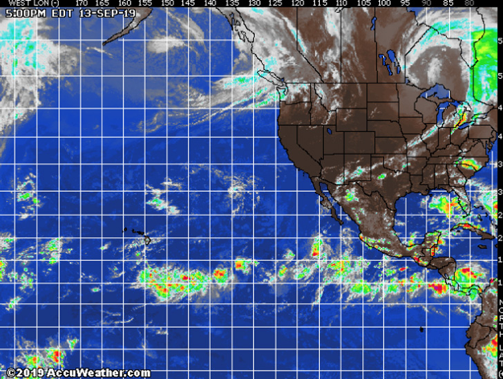
HURRICANE WATCH: Tropical Storm Kiko is located well to the southwest of Baja California as of Friday morning Kiko is moving west-northwest at 10 mph with maximum sustained winds of 40 mph. Conditions will remain favorable for Kiko to strengthen during the next couple of days and it is expected to become a hurricane during the weekend. This tropical cyclone will track west-northwest, away from Mexico and into the open waters of the eastern Pacific. Kiko will eventually encounter less favorable atmospheric conditions next week and slowly weaken.
In addition, we may see yet another tropical system develop early next week closer to the coast of southern Mexico. While recent computer model output keeps this future developing system offshore, it will be close enough that a small shift northward in the projected track would lead to land impacts. As a result, this will be monitored closely in the coming days.

______________________________________________________________________________________________________
______________________________________________________________________________________________________
For Saturday morning we will see a continued fade in surf as all swells back down quickly. The top South facing beaches should see inconsistent, waist high + sets with a few larger stragglers waves at the top spots.
Small, steeply angled NW wind swell will be in play as well but it will remain pretty meager.
Saturday
2019-09-14 Sat 04:12 AM 0.38 feet Low Tide
2019-09-14 Sat 06:36 AM Sunrise
2019-09-14 Sat 06:56 AM Moonset
2019-09-14 Sat 10:23 AM 4.82 feet High Tide
2019-09-14 Sat 04:08 PM 1.38 feet Low Tide
2019-09-14 Sat 07:02 PM Sunset
2019-09-14 Sat 07:44 PM Moonrise
2019-09-14 Sat 10:12 PM 5.35 feet High Tide
The conditions look fair with variable 1-4 MPH winds until noon and then 7-9 MPH out of the SW in the afternoon. The air temp tops out at 78 degrees.
______________________________________________________________________________________________________
For Sunday morning we will toil in the knee to waist high + zone with the South facing breaks being the best bet.
Small, steeply angled NW wind swell will provide knee high + boat wake style surf.
Sunday
2019-09-15 Sun 04:35 AM 0.63 feet Low Tide
2019-09-15 Sun 06:37 AM Sunrise
2019-09-15 Sun 07:50 AM Moonset
2019-09-15 Sun 10:45 AM 4.92 feet High Tide
2019-09-15 Sun 04:40 PM 1.29 feet Low Tide
2019-09-15 Sun 07:00 PM Sunset
2019-09-15 Sun 08:12 PM Moonrise
2019-09-15 Sun 10:43 PM 5.05 feet High Tide
The conditions look okay with 1-5 MPH winds, out of the South until noon, and then 4-8 MPH out of the SW in the afternoon. The air temp holds at 78 degrees.
______________________________________________________________________________________________________
For Monday morning we’ll go back to the drawing board with knee to waist high surf everywhere.
Monday
2019-09-16 Mon 04:57 AM 0.95 feet Low Tide
2019-09-16 Mon 06:37 AM Sunrise
2019-09-16 Mon 08:45 AM Moonset
2019-09-16 Mon 11:08 AM 4.97 feet High Tide
2019-09-16 Mon 05:15 PM 1.26 feet Low Tide
2019-09-16 Mon 06:59 PM Sunset
2019-09-16 Mon 08:41 PM Moonrise
2019-09-16 Mon 11:18 PM 4.65 feet High Tide
The conditions look fair with 1-4 MPH variable winds until 12:00PM and then 7-9 MPH out of the SW in the afternoon. The air temp holds at 78 degrees.
______________________________________________________________________________________________________
For Tuesday morning we’ll lock into the same story with continued knee to waist high surf.
Tuesday
2019-09-17 Tue 05:20 AM 1.32 feet Low Tide
2019-09-17 Tue 06:38 AM Sunrise
2019-09-17 Tue 09:40 AM Moonset
2019-09-17 Tue 11:34 AM 4.99 feet High Tide
2019-09-17 Tue 05:55 PM 1.29 feet Low Tide
2019-09-17 Tue 06:57 PM Sunset
2019-09-17 Tue 09:11 PM Moonrise
2019-09-17 Tue 11:57 PM 4.19 feet High Tide
The conditions look fair with 1-6 MPH winds out of the SW until 12:00PM and then 7-10 MPH out of the SW in the afternoon. The air temp tops out at 75 degrees.
______________________________________________________________________________________________________
Water temps are as follows, (day of 4CAST update) and are as follows: Malibu 68 Santa Monica 69 South Bay 71, Huntington 70, Newport 75 .
______________________________________________________________________________________________________
The next 4Cast will be updated on Sunday afternoon.
______________________________________________________________________________________________________
ABOUT THE SWELLMAGNET FORECAST – One of the most exciting–and yet most challenging–aspects of surfing is the sheer variety of waves and weather conditions that affect the entire surfing experience. Any surfer who is interested in going beyond the most basic level of surfing will have to develop the ability to interpret waves and environmental conditions. This is important for ensuring both a safe and enjoyable experience.
The main difficulty lies in predicting how exactly the ocean and the environment will behave at any given time. One day, you could be riding four-footers all day and the next, you might be facing a glasslike surface with nary a ripple. Conditions can change drastically from day-to-day and even within the space of a couple of hours. To avoid wasted time and unproductive trips to the surf, it is essential to have access to reliable information on surf conditions.
Sites such as Swellmagnet.com offer up-to-the-minute surf reports that are essential to all California surfers. The company relies on an extensive network of surf cams and surf experts in order to monitor the precise surf conditions on any given day. All information is collated and analyzed by qualified surf specialists, with the resulting data being provided to the public via the Swellmagnet site.
Swellmagnet provides some of the best surf reports in the industry, with accurate and verifiable results gathered via an innovative system of surf condition monitors and detectors. Expert surf analysis is provided by the company’s team of highly experienced specialists, each with long years of experience monitoring and actually experiencing the full range of surf conditions. This combination of state-of-the-art technology and extensive practical experience ensures the highest quality and most accurate surf reports available.
For surfers who wish to take full advantage of the best that the California coast has to offer, the services provided by Swellmagnet are essential.

This Surf Forecast is brought to you by Anderson Surfboards!
