SURF FORECAST UPDATED MONDAY 10-29-12
__________________________________________________
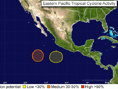
HURRICANE REPORT – There’s are two disturbance off of Mainland Mexico this morning with a medium chance of developing into a Tropical Storm… stay tuned.

__________________________________________________
For Tuesday morning should see more of the same as that NW energy continues to generate some fun little,waist to stomach high sets for the most exposed breaks.
The tides look good for the early morning, but will slow things down later with a nearly 6 foot high at 9:45AM.
Tuesday
2012-10-30 03:34 AM PDT 1.83 feet Low
2012-10-30 09:45 AM PDT 5.77 feet High
2012-10-30 04:45 PM PDT -0.06 feet Low
2012-10-30 11:06 PM PDT 3.87 feet High
The conditions look fair with light and variable breezes in the 1-4 MPH zone until 11AM and afternoon onshores up into the 8-10 MPH range. Look for a high air temp of 77 degrees.
__________________________________________________
Wednesday morning looks to be a hair smaller with waist high plus sets out of the West from a 290 degree angle with 10-12 second intervals.
Wednesday
2012-10-31 03:59 AM PDT 2.07 feet Low
2012-10-31 10:11 AM PDT 5.67 feet High
2012-10-31 05:19 PM PDT 0.03 feet Low
2012-10-31 11:46 PM PDT 3.67 feet High
The conditions don’t look really nice as the high pressure eases slightly but generates mile NE winds in the 2-6 MPH zone until 11AM and afternoon onshores up into the 6-8 MPH range. Look for a high air temp of 70 degrees.
__________________________________________________
Thursday morning should see a slight bump in size with 12-14 second interval energy, from a 290 degree angle puts the better West facing breaks into the waist to stomach high range.
Thursday
2012-11-01 04:25 AM PDT 2.30 feet Low
2012-11-01 10:39 AM PDT 5.50 feet High
2012-11-01 05:57 PM PDT 0.19 feet Low
The conditions don’t look great but should be manageable with variable winds out of the West in the 4-6 MPH zone until noon and light onshore winds to 10 into the afternoon. Look for a high air temp of 65 degrees on the sand.
__________________________________________________
On Friday morning the swell will dip back down into the waist high plus range for the best West facing breaks. Nothing to get hopped up about but not flat either. It’s only a matter of time until the Dam cracks and the NPAC sends us a flood of NW energy!
Friday
2012-11-02 12:33 AM PDT 3.47 feet High
2012-11-02 04:52 AM PDT 2.55 feet Low
2012-11-02 11:10 AM PDT 5.27 feet High
2012-11-02 06:39 PM PDT 0.40 feet Low
The conditions look fair with variable winds out of the West in the 2-6 MPH zone until noon and continued onshore winds to 12 MPHinto the afternoon. Look for a high air temp of 68 degrees on the sand.
__________________________________________________
The current water temps are as follows – Newport 66 degrees, Huntington 66 degrees, the South Bay showed as 65 degrees, Santa Monica 64 degrees and Malibu 60 degrees.
____________________________________________________
I’ll be back on Tuesday with the 5DAY 4CAST!
____________________________________________________
If you’re stoked on our free service take a second to Like us on Facebook
