Southern California Surf 4cast Updated 5 – 5 – 2024
The Surf Forecast will be updated Wednesdays, Fridays and Sundays.
E
Be sure to Sign-up for our free email blast to be notified when the latest Forecast is released! Receive Surf, Shark, & Water Quality Alerts. Stay on top of Local News & Events.
Subscribe Now
MONDAY Surf Forecast
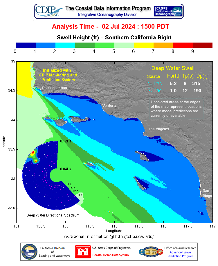
Okay, it looks like we’re all set up for a pretty fun week of waves. Nothing to really knock your socks off, but a nice combination of energy out of the NW and SW respectively. Being at the right place at the right time will be paramount to scoring good waves. Life always seems a hair more interesting when there is at least a possibility of racking up a few fun ones!
We’ll have to wait and see what the winds leave behind for us, but as of today, it looks like we should have at least chest high + NW wind swell from 310 degrees with 8-10 second intervals. Smaller pulses of Southerly energy will remain in play, but nothing you can really put your finger on. The winds are supposed to shift to an offshore direction around midnight, (Sunday night), and continue to blow that direction until noon so, in a perfect world, the sea surface should be nice and groomed for Weekday Warriors.
ehhh… a little high at Prime Time – Mon 08:57 AM 4.44′ High
Monday
2024-05-06 Mon 02:50 AM -0.51′ Low
2024-05-06 Mon 04:55 AM Moonrise
2024-05-06 Mon 05:59 AM Sunrise
2024-05-06 Mon 08:57 AM 4.44′ High
2024-05-06 Mon 02:28 PM 0.72′ Low
2024-05-06 Mon 06:27 PM Moonset
2024-05-06 Mon 07:42 PM Sunset
2024-05-06 Mon 08:45 PM 6.38′ High
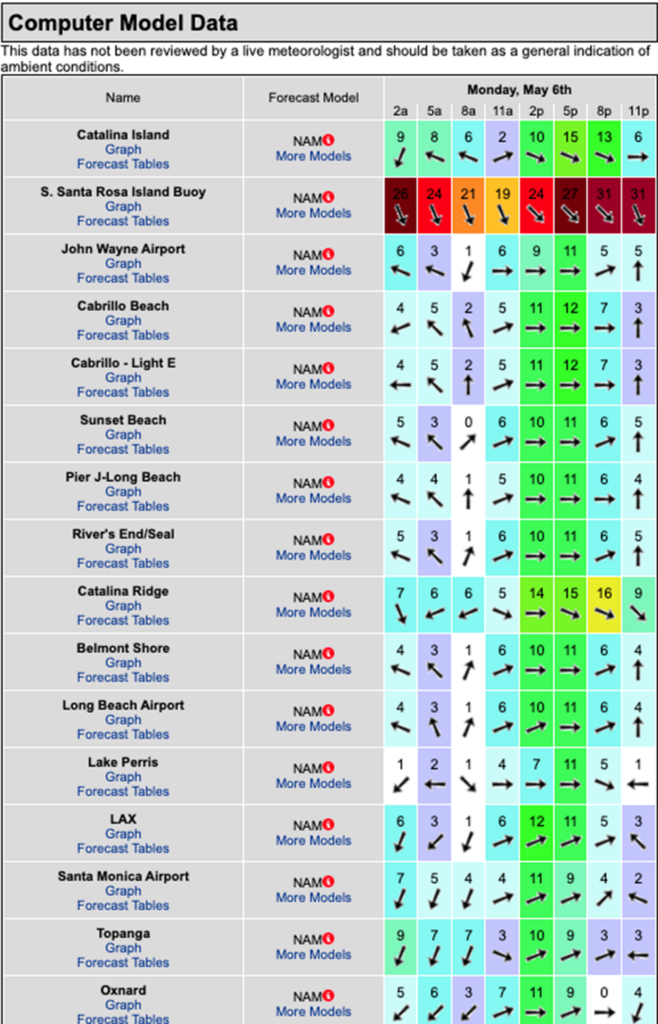
The conditions – The conditions should improve dramatically for most beaches, with an offshore/side shore wind direction until around noon, followed by stronger W/SW breezes into the evening. The air temp bumps up to 67 degrees.
TUESDAY Surf Forecast
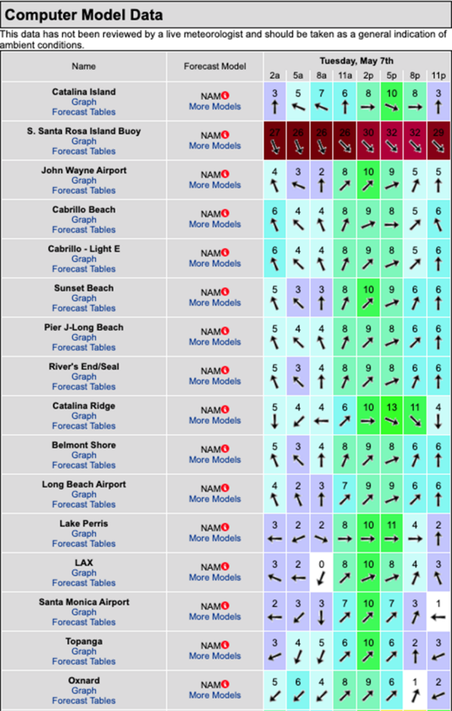
That NW wind swell won’t have much, if anything left in the tank, so things start off a little slow in the AM, but we should start to see some “Scout sets” from an impending SW swell start to filter in throughout the day. First we will see inconsistent chest high sets followed more potent pulses in the late afternoon.
Tuesday
2024-05-07 Tue 03:36 AM -1.05′ Low
2024-05-07 Tue 05:29 AM Moonrise
2024-05-07 Tue 05:58 AM Sunrise
2024-05-07 Tue 09:51 AM 4.23′ High
2024-05-07 Tue 03:03 PM 1.13′ Low
2024-05-07 Tue 07:40 PM Moonset
2024-05-07 Tue 07:43 PM Sunset
2024-05-07 Tue 08:24 PM New Moon
2024-05-07 Tue 09:19 PM 6.60′ High
The conditions – The conditions should be pretty good until around 11:00AM with a mixed bag of light winds, giving way to to stronger SW winds into the afternoon The air temp holds at 67 degrees.
WEDNESDAY Surf Forecast
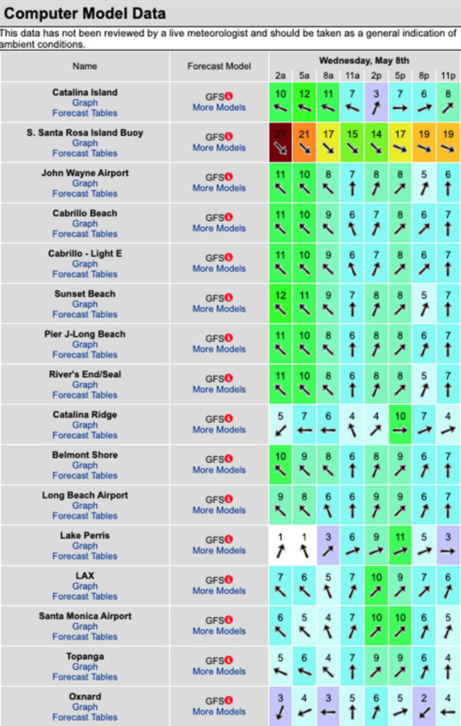
The potential for a really good day of surf is high! We’ll have a solid SW swell from 200-205 degrees with 16-17 second intervals teaming up with a noteworthy NW wind swell from 310 degrees with 9-10 second intervals. The receptive beaches should both see surf in the chest to shoulder high zone with the top spots in the OC and San O’ areas seeing OH sets.
Dual exposure beach breaks should have some nice wedges too. The winds look a little iffy so I’d check the cams before committing to any one location. Happy Hunting!
Wednesday
2024-05-08 Wed 04:23 AM -1.34′ Low
2024-05-08 Wed 05:57 AM Sunrise
2024-05-08 Wed 06:07 AM Moonrise
2024-05-08 Wed 10:45 AM 3.97′ High
2024-05-08 Wed 03:38 PM 1.56′ Low
2024-05-08 Wed 07:43 PM Sunset
2024-05-08 Wed 08:54 PM Moonset
2024-05-08 Wed 09:55 PM 6.60′ High
The conditions – That S/SE/SSE flow will once again dominate the air waves until around noon with minor SW breezes taking over in the afternoon and prevailing until days end. The air temp remains at 67 degrees.
THURSDAY Surf Forecast
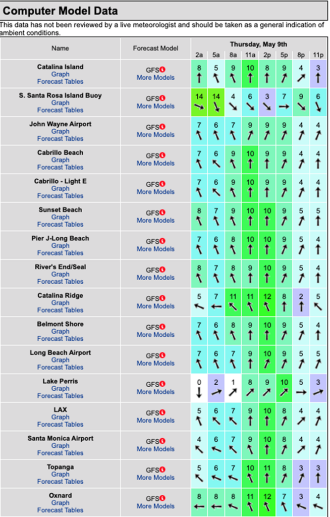
It’s shaping up to be another fun day for waves as both the Southerly and Westerly facing beaches get an ample supply of surf throughout the day. The SW swell will have a bit more fire in its belly with 14-15 second intervals from 200 degrees, but the wind swell will continue to make a solid contribution from 310 degrees with 10-12 second intervals. Not too shabby for May… who knows… maybe the water will even warm up some day!!!
Tuesday
2024-05-07 Tue 03:36 AM -1.05′ Low
2024-05-07 Tue 05:29 AM Moonrise
2024-05-07 Tue 05:58 AM Sunrise
2024-05-07 Tue 09:51 AM 4.23′ High
2024-05-07 Tue 03:03 PM 1.13′ Low
2024-05-07 Tue 07:40 PM Moonset
2024-05-07 Tue 07:43 PM Sunset
2024-05-07 Tue 08:24 PM New Moon
2024-05-07 Tue 09:19 PM 6.60′ High
The conditions – The conditions should be okay for beaches that like that SE/SSE wind direction early giving way to S/SW winds into the afternoon The air temp bumps up to a toasty 69 degrees.
FRIDAY Surf Forecast
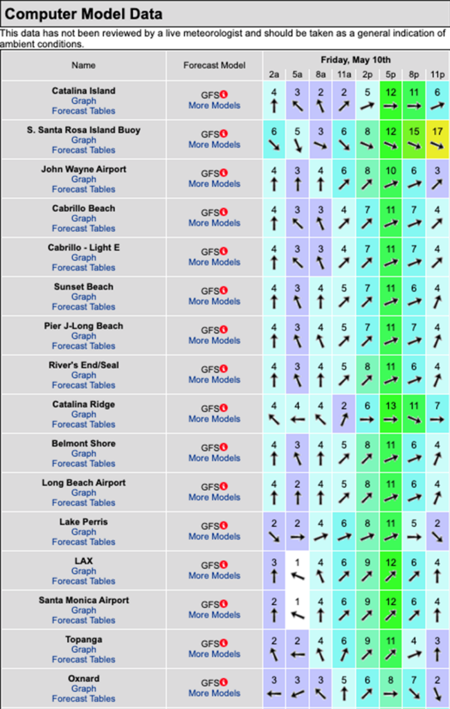
Things look to wind down quickly with the NW wind swell heading for hospice care we will be reliant on the SW energy which will be wheezing itself into a similar situation. The best bet will be the inconsistent waist high + sets, out of the SW, from 200 degrees, with 13 second intervals. Still something to ride, you’ll just have to be patient.
Wednesday
2024-05-08 Wed 04:23 AM -1.34′ Low
2024-05-08 Wed 05:57 AM Sunrise
2024-05-08 Wed 06:07 AM Moonrise
2024-05-08 Wed 10:45 AM 3.97′ High
2024-05-08 Wed 03:38 PM 1.56′ Low
2024-05-08 Wed 07:43 PM Sunset
2024-05-08 Wed 08:54 PM Moonset
2024-05-08 Wed 09:55 PM 6.60′ High
The conditions – The sea surface should be mostly clean until noon with light and variable breezes and stronger SW winds into the afternoon.. The air temp holds at 69 degrees.
Water Temps are as follows, (day of 4CAST update), Malibu 59, Santa Monica 59, South Bay 59,
Huntington 60, Newport 60.
I will be back on Wednesday with the next update.
About the Swell Magnet Forecast
One of the most exciting–and yet most challenging–aspects of surfing is the sheer variety of waves and weather conditions that affect the entire surfing experience. Any surfer who is interested in going beyond the most basic level of surfing will have to develop the ability to interpret waves and environmental conditions. This is important for ensuring both a safe and enjoyable experience.
The main difficulty lies in predicting how exactly the ocean and the environment will behave at any given time. One day, you could be riding four-footers all day and the next, you might be facing a glasslike surface with nary a ripple. Conditions can change drastically from day-to-day and even within the space of a couple of hours. To avoid wasted time and unproductive trips to the surf, it is essential to have access to reliable information on surf conditions.
Sites such as Swellmagnet.com offer up-to-the-minute surf reports that are essential to all California surfers. The company relies on an extensive network of surf cams and surf experts in order to monitor the precise surf conditions on any given day. All information is collated and analyzed by qualified surf specialists, with the resulting data being provided to the public via the Swellmagnet site.
Swellmagnet provides some of the best surf reports in the industry, with accurate and verifiable results gathered via an innovative system of surf condition monitors and detectors. Expert surf analysis is provided by the company’s team of highly experienced specialists, each with long years of experience monitoring and actually experiencing the full range of surf conditions. This combination of state-of-the-art technology and extensive practical experience ensures the highest quality and most accurate surf reports available.
For surfers who wish to take full advantage of the best that the California coast has to offer, the services provided by Swellmagnet are essential.


