_______________________________________________________________________________________________________
SOUTHERN CALIFORNIA SURF FORECAST UPDATED 3-28-17
_______________________________________________________________________________________________________
If you are having problems getting the streams please try using the “Chrome Browser” for all devices, (including Android). Click here for troubleshooting tips! Or feel free to email us for technical support contact us
_______________________________________________________________________________________________________
Good news! The SWELLMAGNET APP is up and running and we moved the website to a new high end server which has made the data load lightning fast. If you haven’t downloaded the APP just type in swellmagnet.com in the App store! It’s 100% FREE! If you have any issues with the APP or the site itself please take a second to let us know. We hope to have everything fine tuned ASAP! contact us

_______________________________________________________________________________________________________
For Wednesday morning we’ll see peaking, NW ground swell surf with the best West facing beaches dishing up shoulder high to OH sets from that same 285-295 degree angle, (with 16-17 second intervals).
Smaller Southerly energy and NW wind swell will remain in the mix and it looks like we’ll see a beautiful day of weather with fantastic morning winds.
Wednesday
2017-03-29 Wed 04:53 AM -0.28 feet Low Tide
2017-03-29 Wed 06:44 AM Sunrise
2017-03-29 Wed 08:02 AM Moonrise
2017-03-29 Wed 11:02 AM 4.91 feet High Tide
2017-03-29 Wed 04:57 PM 0.32 feet Low Tide
2017-03-29 Wed 07:12 PM Sunset
2017-03-29 Wed 09:15 PM Moonset
2017-03-29 Wed 11:10 PM 5.66 feet High Tide
The conditions look excellent with NE/NNE winds in the 1-7 MPH range until noon, (stronger below the passes and canyons), and 10-13 MPH out of the West in the afternoon. The air temp bumps up to a toasty 73 degrees.
______________________________________________________________________________________________________
For Thursday morning we’ll see a little dip in size, but there will be plenty of chest to head high peaks for the top West facing beaches as the intervals for that ground swell drop off to 14-16 seconds, (still providing plenty of pop).
Thursday
2017-03-30 Thu 05:42 AM -0.36 feet Low Tide
2017-03-30 Thu 06:43 AM Sunrise
2017-03-30 Thu 08:45 AM Moonrise
2017-03-30 Thu 11:53 AM 4.43 feet High Tide
2017-03-30 Thu 05:34 PM 0.80 feet Low Tide
2017-03-30 Thu 07:13 PM Sunset
2017-03-30 Thu 10:23 PM Moonset
2017-03-30 Thu 11:50 PM 5.64 feet High Tide
The conditions should be decent early with variable winds out of the East in the 2-4 MPH until 10AM and 6-10 MPH out of the West in the afternoon. The air temp plummets to 67 degrees.
______________________________________________________________________________________________________
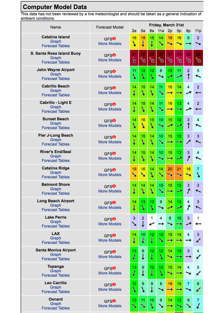
For Friday morning we’ll see that same ground swell continue to diminish with the intervals down to 12-14 seconds from the same 290-295 degree angle. The wind models are calling for poor wind directions and along with it additional wind swell. Hopefully the models flip flop on that scenario. I’ll check it out again tomorrow and update accordingly.
Friday
2017-03-31 Fri 06:37 AM -0.29 feet Low Tide
2017-03-31 Fri 06:42 AM Sunrise
2017-03-31 Fri 09:31 AM Moonrise
2017-03-31 Fri 12:53 PM 3.88 feet High Tide
2017-03-31 Fri 06:15 PM 1.35 feet Low Tide
2017-03-31 Fri 07:14 PM Sunset
2017-03-31 Fri 11:30 PM Moonset
The conditions look poor but hopefully things will change, (see wind model below). The air temp holds at 67 degrees.

_____________________________________________________________________________________________________
For Saturday morning – April Fools Day – we’ll see that NW ground swell on its last legs, dipping down to 12 second intervals. Based on what the winds do on Friday, we could have a nice bump in 10-11 second local wind swell enter stage right as well.
Based on what I know today, the better West facing beaches should see chest to possibly shoulder high sets.
Saturday
2017-04-01 Sat 12:36 AM 5.46 feet High Tide
2017-04-01 Sat 06:40 AM Sunrise
2017-04-01 Sat 07:42 AM -0.12 feet Low Tide
2017-04-01 Sat 10:21 AM Moonrise
2017-04-01 Sat 02:11 PM 3.40 feet High Tide
2017-04-01 Sat 07:05 PM 1.90 feet Low Tide
2017-04-01 Sat 07:15 PM Sunset
The conditions look fair with variable winds in the 1-3 MPH range until noon and 10-13 MPH out of the West in the afternoon. The air temp climbs back up to 70 degrees.
_____________________________________________________________________________________________________
For Sunday morning we’ll be reliant on leftovers with waist to chest high surf for the better West facing breaks.
The good news is another solid NW ground swell will weave its way into the picture from a Westerly angle of 285-290 degree angle and muscley 18 second intervals. Don’t expect to see much consistency in the AM, but the Scout sets could start showing up in the afternoon.
Sunday
2017-04-02 Sun 12:34 AM Moonset
2017-04-02 Sun 01:32 AM 5.17 feet High Tide
2017-04-02 Sun 06:39 AM Sunrise
2017-04-02 Sun 09:02 AM 0.03 feet Low Tide
2017-04-02 Sun 11:15 AM Moonrise
2017-04-02 Sun 03:56 PM 3.22 feet High Tide
2017-04-02 Sun 07:15 PM Sunset
2017-04-02 Sun 08:21 PM 2.35 feet Low Tide
The conditions look okay with variable winds in the 2-3 MPH range until 10AM and 6-10 MPH out of the West in the afternoon. The air temp holds at 70 degrees.
_____________________________________________________________________________________________________
Water Temps: are as follows – Malibu 57, Santa Monica 58, Hermosa 60, Huntington 57 and Newport 58 degrees. Click the tides tab on the widget below for updated water temps or if you’re on a mobile device just scroll down!
______________________________________________________________________________________________________
I will be back on Wednesday to tighten things up!
______________________________________________________________________________________________________
ABOUT THE SWELLMAGNET FORECAST – One of the most exciting–and yet most challenging–aspects of surfing is the sheer variety of waves and weather conditions that affect the entire surfing experience. Any surfer who is interested in going beyond the most basic level of surfing will have to develop the ability to interpret waves and environmental conditions. This is important for ensuring both a safe and enjoyable experience.
The main difficulty lies in predicting how exactly the ocean and the environment will behave at any given time. One day, you could be riding four-footers all day and the next, you might be facing a glasslike surface with nary a ripple. Conditions can change drastically from day-to-day and even within the space of a couple of hours. To avoid wasted time and unproductive trips to the surf, it is essential to have access to reliable information on surf conditions.
Sites such as Swellmagnet.com offer up-to-the-minute surf reports that are essential to all California surfers. The company relies on an extensive network of surf cams and surf experts in order to monitor the precise surf conditions on any given day. All information is collated and analyzed by qualified surf specialists, with the resulting data being provided to the public via the Swellmagnet site.
Swellmagnet provides some of the best surf reports in the industry, with accurate and verifiable results gathered via an innovative system of surf condition monitors and detectors. Expert surf analysis is provided by the company’s team of highly experienced specialists, each with long years of experience monitoring and actually experiencing the full range of surf conditions. This combination of state-of-the-art technology and extensive practical experience ensures the highest quality and most accurate surf reports available.
For surfers who wish to take full advantage of the best that the California coast has to offer, the services provided by Swellmagnet are essential.
