_______________________________________________________________________________________________________
SOUTHERN CALIFORNIA SURF FORECAST UPDATED 4-19-17
_______________________________________________________________________________________________________
If you are having problems getting the streams please try using the “Chrome Browser” for all devices, (including Android). Click here for troubleshooting tips! Or feel free to email us for technical support contact us
_______________________________________________________________________________________________________
Good news! The SWELLMAGNET APP is up and running and we moved the website to a new high end server which has made the data load lightning fast. If you haven’t downloaded the APP just type in swellmagnet.com in the App store! It’s 100% FREE! If you have any issues with the APP or the site itself please take a second to let us know. We hope to have everything fine tuned ASAP! contact us

_______________________________________________________________________________________________________
For Thursday morning we’ll see some fresh swell roll in out of the NW from a 295 degree angle with 12-13 second intervals. This energy will start off with chest high sets in the AM, but dish up shoulder to head high + surf for the better West facing beaches later in the day as it fills in.
We’ll also see that SW energy on its last legs with sporadic waist high + sets.
In addition, another small but potent pulse of SW swell will show up late in the day with 18-20 second intervals from a 195-200 degree angle.
Thursday
2017-04-20 Thu 02:38 AM Moonrise
2017-04-20 Thu 04:59 AM 3.94 feet High Tide
2017-04-20 Thu 06:16 AM Sunrise
2017-04-20 Thu 12:14 PM 0.47 feet Low Tide
2017-04-20 Thu 01:35 PM Moonset
2017-04-20 Thu 07:07 PM 3.86 feet High Tide
2017-04-20 Thu 07:29 PM Sunset
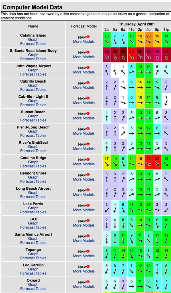
The conditions look strange to say the least so you be the judge. The air temp climbs up to 70 degrees.
______________________________________________________________________________________________________
For Friday morning that NW energy will hit full stride with head high to OH sets at the best West facing breaks. The angle will be from 290 degrees + and the intervals will remain at 12-13 seconds.
The Southern Hemi swell will also peak with chest to shoulder high sets with 18 + second intervals from that same liberal angle of 200 degrees. The top spots in the OC and San O’ areas will have the most juice but even breaks with modest SW exposure should see a little bonus action. Combo spots should be “rockin”.
Friday
2017-04-21 Fri 12:29 AM 2.23 feet Low Tide
2017-04-21 Fri 03:18 AM Moonrise
2017-04-21 Fri 06:07 AM 4.18 feet High Tide
2017-04-21 Fri 06:15 AM Sunrise
2017-04-21 Fri 12:54 PM 0.28 feet Low Tide
2017-04-21 Fri 02:34 PM Moonset
2017-04-21 Fri 07:30 PM Sunset
2017-04-21 Fri 07:30 PM 4.26 feet High Tide
The conditions look pretty good with N/NNE breezes at 2-6 MPH until noon, (stronger below passes and canyons), and 6-13 MPH winds out of the West in the afternoon. The air temp tops skyrockets to 79 degrees
_____________________________________________________________________________________________________
For Saturday morning both the NW and that Southern Hemi swell will be on the fade but there will be plenty of solid surf up and down the coast. We should see chest to shoulder high sets from both the NW and SW angles.
The tide’s a little ripe at 7AM but shouldn’t kill it.
Saturday
2017-04-22 Sat 01:13 AM 1.63 feet Low Tide
2017-04-22 Sat 03:57 AM Moonrise
2017-04-22 Sat 06:14 AM Sunrise
2017-04-22 Sat 07:01 AM 4.47 feet High Tide
2017-04-22 Sat 01:30 PM 0.14 feet Low Tide
2017-04-22 Sat 03:36 PM Moonset
2017-04-22 Sat 07:30 PM Sunset
2017-04-22 Sat 07:55 PM 4.71 feet High Tide
The conditions look to be fair with light and variable breezes in the 1-3 MPH range until 10AM and 7-12 MPH winds out of the West in the afternoon. The air temp bumps up another notch to 81 degrees.
_____________________________________________________________________________________________________
For Sunday morning that Southern Hemi swell and Northern Hemi swell will continue to fade with sporadic waist to chest high sets in the morning. We will however get a boost in surf courtesy of a new NW swell that will come dome down the line from a very Westerly 280-285 degree angle with 13 second intervals. It will slowly fill in through the day and be bigger and more consistent for Monday morning.
* TIDE’S A LITTLE FAT IN THE MORNING AGAIN – 07:50 AM 4.71 feet High Tide
Sunday
2017-04-23 Sun 01:54 AM 0.96 feet Low Tide
2017-04-23 Sun 04:35 AM Moonrise
2017-04-23 Sun 06:13 AM Sunrise
2017-04-23 Sun 07:50 AM 4.71 feet High Tide
2017-04-23 Sun 02:04 PM 0.09 feet Low Tide
2017-04-23 Sun 04:39 PM Moonset
2017-04-23 Sun 07:31 PM Sunset
2017-04-23 Sun 08:22 PM 5.18 feet High Tide
The conditions look okay with variable 2-6 breezes out of the S/SE/SSE until 11AM and 7-11 MPH winds out of the West in the afternoon. The air temp tops out at a comfy 77 degrees.
_____________________________________________________________________________________________________
Water Temps: are as follows – Malibu 56, Santa Monica 61, Hermosa 62, Huntington 59 and Newport 59 degrees. Click the tides tab on the widget below for updated water temps or if you’re on a mobile device just scroll down!
______________________________________________________________________________________________________
I will be back on Thursday with a look into next week!
______________________________________________________________________________________________________
ABOUT THE SWELLMAGNET FORECAST – One of the most exciting–and yet most challenging–aspects of surfing is the sheer variety of waves and weather conditions that affect the entire surfing experience. Any surfer who is interested in going beyond the most basic level of surfing will have to develop the ability to interpret waves and environmental conditions. This is important for ensuring both a safe and enjoyable experience.
The main difficulty lies in predicting how exactly the ocean and the environment will behave at any given time. One day, you could be riding four-footers all day and the next, you might be facing a glasslike surface with nary a ripple. Conditions can change drastically from day-to-day and even within the space of a couple of hours. To avoid wasted time and unproductive trips to the surf, it is essential to have access to reliable information on surf conditions.
Sites such as Swellmagnet.com offer up-to-the-minute surf reports that are essential to all California surfers. The company relies on an extensive network of surf cams and surf experts in order to monitor the precise surf conditions on any given day. All information is collated and analyzed by qualified surf specialists, with the resulting data being provided to the public via the Swellmagnet site.
Swellmagnet provides some of the best surf reports in the industry, with accurate and verifiable results gathered via an innovative system of surf condition monitors and detectors. Expert surf analysis is provided by the company’s team of highly experienced specialists, each with long years of experience monitoring and actually experiencing the full range of surf conditions. This combination of state-of-the-art technology and extensive practical experience ensures the highest quality and most accurate surf reports available.
For surfers who wish to take full advantage of the best that the California coast has to offer, the services provided by Swellmagnet are essential.

