_______________________________________________________________________________________________________
SOUTHERN CALIFORNIA SURF FORECAST UPDATED 4-23-17
_______________________________________________________________________________________________________
If you are having problems getting the streams please try using the “Chrome Browser” for all devices, (including Android). Click here for troubleshooting tips! Or feel free to email us for technical support contact us
_______________________________________________________________________________________________________
Good news! The SWELLMAGNET APP is up and running and we moved the website to a new high end server which has made the data load lightning fast. If you haven’t downloaded the APP just type in swellmagnet.com in the App store! It’s 100% FREE! If you have any issues with the APP or the site itself please take a second to let us know. We hope to have everything fine tuned ASAP! contact us

_______________________________________________________________________________________________________
Lots of surf and wind headed our way, and as we all know, the wind models are usually fickle and carry an element of unpredictability along with them. All I can say is… stay tuned to the forecast as I will update things daily. It will all be about finding those windows of opportunity should they arise.
_______________________________________________________________________________________________________
For Monday morning that NW energy will hit full stride with head high to WOH, (Well OH), sets at the best West facing breaks. The angle will be from 285-290 degrees + and the intervals will remain at 12-13 seconds. We’ll also see some really short 8-9 second interval NW energy join the party.
The Southern Hemi swell will dip a hair to 15 seconds but should continue to throw inconsistent chest high sets at breaks with good SW exposure. It will pale in comparison to the mix of NW energy and likely be lost in the mix.
* TIDE’S A LITTLE FAT IN THE MORNING AGAIN – 08:36 AM 4.86 feet High Tide
Monday
2017-04-24 Mon 02:33 AM 0.30 feet Low Tide
2017-04-24 Mon 05:14 AM Moonrise
2017-04-24 Mon 06:11 AM Sunrise
2017-04-24 Mon 08:36 AM 4.86 feet High Tide
2017-04-24 Mon 02:38 PM 0.14 feet Low Tide
2017-04-24 Mon 05:45 PM Moonset
2017-04-24 Mon 07:32 PM Sunset
2017-04-24 Mon 08:52 PM 5.63 feet High Tide
The conditions look pretty good for spots that like a Southerly wind direction with variable breezes at 1-3 MPH until 11AM and 7-11 MPH winds out of the West in the afternoon. The air temp tops out at 68 degrees
_____________________________________________________________________________________________________
For Tuesday morning looks like another solid day for waves. We will see that med interval NW energy continue to churn out head high to WOH waves for the best West facing breaks. That SW energy will continue its slow fade, but still contribute to the cause with sporadic chest high sets, but once again, it will not be visible to the naked eye.
We will also see another round of solid SW energy enter the fray. This swell won’t start filling in until later in the day but will carry with it muscley, 16-18 second intervals from a fairly steep 185-190 degree angle so the South facing breaks will definitely see a bit more action on Wednesday!
* TIDE’S A LITTLE FAT IN THE MORNING AGAIN – 09:23 AM 4.88 feet High Tide
Tuesday
2017-04-25 Tue 03:15 AM -0.30 feet Low Tide
2017-04-25 Tue 05:53 AM Moonrise
2017-04-25 Tue 06:10 AM Sunrise
2017-04-25 Tue 09:23 AM 4.88 feet High Tide
2017-04-25 Tue 03:13 PM 0.30 feet Low Tide
2017-04-25 Tue 06:53 PM Moonset
2017-04-25 Tue 07:33 PM Sunset
2017-04-25 Tue 09:25 PM 6.01 feet High Tide
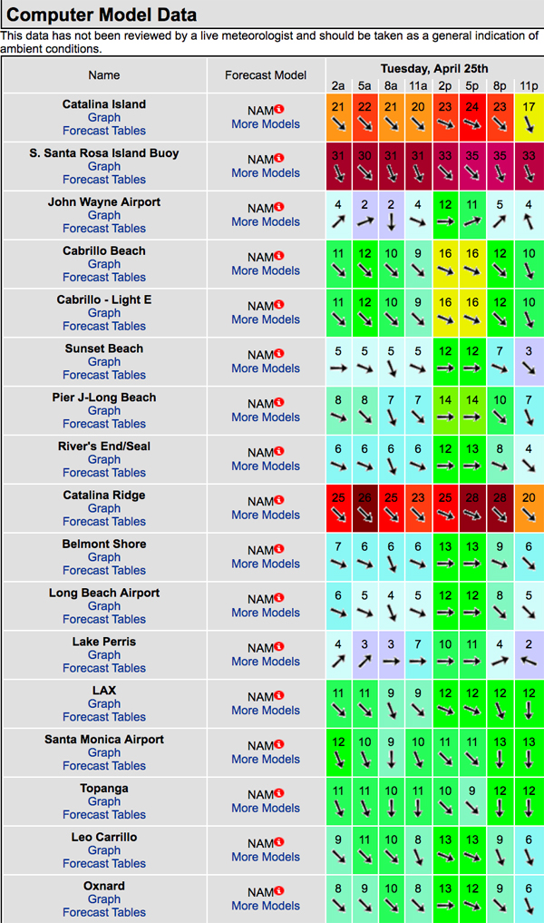
The conditions look funky to say the least so see the wind model graph below and try and decipher that mess yourself. The air temp tops out at 71 degrees.

_____________________________________________________________________________________________________
For Wednesday morning the NW swell will be on the fade but there will be plenty of solid surf in the chest to shoulder high zone.
We will also see that Southern Hemi energy peak with chest high sets with 16 second intervals from 200 degrees. The South facing breaks should see some nice sets rolling through and the spots in the OC and San O’ areas will have the most size and consistency.
* Nice tide push through the morning.
Wednesday
2017-04-26 Wed 03:59 AM -0.76 feet Low Tide
2017-04-26 Wed 05:18 AM New Moon
2017-04-26 Wed 06:09 AM Sunrise
2017-04-26 Wed 06:35 AM Moonrise
2017-04-26 Wed 10:11 AM 4.76 feet High Tide
2017-04-26 Wed 03:49 PM 0.57 feet Low Tide
2017-04-26 Wed 07:33 PM Sunset
2017-04-26 Wed 08:03 PM Moonset
2017-04-26 Wed 10:01 PM 6.25 feet High Tide
The conditions look to improve with light and variable breezes out of the N/NNE in the 1-6 MPH range until noon and 12-14 MPH winds out of the West in the afternoon. The air temp tops out at 74 degrees.
_____________________________________________________________________________________________________
For Thursday morning we’ll see another round of NW energy pick up steam throughout the day. The morning should dish up chest high sets out of the NW and w=inconsistent waist to chest high sets out of the SW.
* Nice tide push through the morning.
Thurday
2017-04-27 Thu 04:45 AM -1.04 feet Low Tide
2017-04-27 Thu 06:08 AM Sunrise
2017-04-27 Thu 07:21 AM Moonrise
2017-04-27 Thu 11:02 AM 4.51 feet High Tide
2017-04-27 Thu 04:28 PM 0.93 feet Low Tide
2017-04-27 Thu 07:34 PM Sunset
2017-04-27 Thu 09:13 PM Moonset
2017-04-27 Thu 10:40 PM 6.31 feet High Tide
The conditions look iffy with variable 2-10 MPH breezes out of the West until 11AM and then crank up to 9-20 MPH onshore in the afternoon. The air temp tops out at a toasty 77 degrees.
_____________________________________________________________________________________________________
For Friday morning the NW swell will peak with OH to WOH surf for the exposed West facing breaks. Brutal winds are forecasted to accompany the surf so it could be ugly out there. Stay tuned.
* Nice tide push through the morning.
Friday
2017-04-28 Fri 05:35 AM -1.11 feet Low Tide
2017-04-28 Fri 06:07 AM Sunrise
2017-04-28 Fri 08:11 AM Moonrise
2017-04-28 Fri 11:58 AM 4.18 feet High Tide
2017-04-28 Fri 05:09 PM 1.36 feet Low Tide
2017-04-28 Fri 07:35 PM Sunset
2017-04-28 Fri 10:21 PM Moonset
2017-04-28 Fri 11:23 PM 6.17 feet High Tide
The conditions look horrific with ferocious 15-30 MPH onshore winds all day long. The air temp tops out at 75 degrees.
_____________________________________________________________________________________________________
Water Temps: are as follows – Malibu 58, Santa Monica 63, Hermosa 63, Huntington 60 and Newport 61 degrees. Click the tides tab on the widget below for updated water temps or if you’re on a mobile device just scroll down!
______________________________________________________________________________________________________
I will be back on Monday with the next update!
______________________________________________________________________________________________________
ABOUT THE SWELLMAGNET FORECAST – One of the most exciting–and yet most challenging–aspects of surfing is the sheer variety of waves and weather conditions that affect the entire surfing experience. Any surfer who is interested in going beyond the most basic level of surfing will have to develop the ability to interpret waves and environmental conditions. This is important for ensuring both a safe and enjoyable experience.
The main difficulty lies in predicting how exactly the ocean and the environment will behave at any given time. One day, you could be riding four-footers all day and the next, you might be facing a glasslike surface with nary a ripple. Conditions can change drastically from day-to-day and even within the space of a couple of hours. To avoid wasted time and unproductive trips to the surf, it is essential to have access to reliable information on surf conditions.
Sites such as Swellmagnet.com offer up-to-the-minute surf reports that are essential to all California surfers. The company relies on an extensive network of surf cams and surf experts in order to monitor the precise surf conditions on any given day. All information is collated and analyzed by qualified surf specialists, with the resulting data being provided to the public via the Swellmagnet site.
Swellmagnet provides some of the best surf reports in the industry, with accurate and verifiable results gathered via an innovative system of surf condition monitors and detectors. Expert surf analysis is provided by the company’s team of highly experienced specialists, each with long years of experience monitoring and actually experiencing the full range of surf conditions. This combination of state-of-the-art technology and extensive practical experience ensures the highest quality and most accurate surf reports available.
For surfers who wish to take full advantage of the best that the California coast has to offer, the services provided by Swellmagnet are essential.
