______________________________________________________________________________
[easyrotator]erc_17_1389908460[/easyrotator]
Today’s Slideshow is courtesy of Ruben Pina – Tyler Hatzikian and his crew scoring a few good ones! – If you see a photo you like you can contact Ruben directly at [email protected] to buy a hi-res version for the wall!
______________________________________________________________________________
SOUTHERN CALIFORNIA SURF FORECAST UPDATED 1-20-14
______________________________________________________________________________
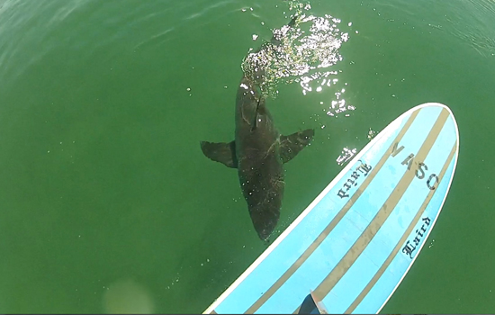
 If you haven’t seen the Video of the Great White Shark encounter, at El Porto, from 10-16-13
Check it out!
______________________________________________________________________________
Tons of swell out there right now but everything I looked at still seemed super crowded. I’m guessing that the rabid mentality will go on for at least a week, (in light of the lack of swell this winter), but then people will relax a bit after they get a few under their belt. With conditions remaining good and a constant barrage of NW swell it might be a good time to hunt around a bit for lighter crowds and different set ups. Happy Hunting!
______________________________________________________________________________
For Tuesday morning the top West facing breaks should go head high plus on the sets in the early AM and a new NW swell will overlap and build in through the day. By days end we should be back into the overhead zone for the top West facing beaches.
Tuesday
2014-01-21 Tue 12:20 AM 4.16 feet High Tide
2014-01-21 Tue 06:04 AM 2.04 feet Low Tide
2014-01-21 Tue 06:57 AM Sunrise
2014-01-21 Tue 09:45 AM Moonset
2014-01-21 Tue 11:37 AM 3.93 feet High Tide
2014-01-21 Tue 05:13 PM Sunset
2014-01-21 Tue 06:09 PM 0.89 feet Low Tide
2014-01-21 Tue 10:34 PM Moonrise
The conditions will be pretty good again with continued NE/NNE breezes in the 2-6 MPH zone until 11AM and 3-9 MPH, out of the West in the afternoon. The air temp jumps back up to a toasty 80 degrees again.
______________________________________________________________________________
Wednesday morning will taper off a hair as that swell eases and another long interval swell fills in through the day. The better West facing breaks will hover in the head high to overhead zone and pick up a little more steam through the day.
Wednesday
2014-01-22 Wed 01:02 AM 4.25 feet High Tide
2014-01-22 Wed 06:56 AM Sunrise
2014-01-22 Wed 07:17 AM 2.02 feet Low Tide
2014-01-22 Wed 10:19 AM Moonset
2014-01-22 Wed 12:35 PM 3.34 feet High Tide
2014-01-22 Wed 05:14 PM Sunset
2014-01-22 Wed 06:45 PM 1.30 feet Low Tide
2014-01-22 Wed 11:31 PM Moonrise
The conditions will remain good with offshore breezes out of the NNE in the 5-10 MPH zone until noon and 8-10 MPH out of the West in the afternoon. The air temp tops out at a 78 degrees.
______________________________________________________________________________
By Thursday morning the top West facing breaks will get yet another interjection of long interval NW swell from a 290-300 degree swell. The most exposed breaks will remain head high to overhead.
Thursday
2014-01-23 Thu 01:53 AM 4.40 feet High Tide
2014-01-23 Thu 06:56 AM Sunrise
2014-01-23 Thu 08:53 AM 1.79 feet Low Tide
2014-01-23 Thu 10:55 AM Moonset
2014-01-23 Thu 02:08 PM 2.84 feet High Tide
2014-01-23 Thu 05:15 PM Sunset
2014-01-23 Thu 07:33 PM 1.69 feet Low Tide
2014-01-23 Thu 09:21 PM Last Quarter
The conditions will remain great early, with continued NE/NNE breezes in the 2-10 MPH zone until 11AM and 6-8 MPH West winds in the afternoon. The air temp tops out at 72 degrees.
______________________________________________________________________________
The current water temps Newport 60 degrees, Huntington 60 degrees, the South Bay showed as 59 degrees, Santa Monica 60 degrees and Malibu 59 degrees.
______________________________________________________________________________
I’ll be back on Tuesday with the 5DAY 4CAST!
______________________________________________________________________________
