______________________________________________________________________________
[easyrotator]erc_52_1390602810[/easyrotator]
Today’s Slideshow is courtesy of Jason Goodwin – The South Bay 1-22-14 – If you see a photo you like you can contact Jason directly at [email protected] to buy a hi-res version for the wall!
______________________________________________________________________________
SOUTHERN CALIFORNIA SURF FORECAST UPDATED 1-24-14
______________________________________________________________________________
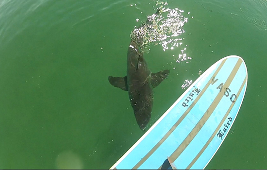
 If you haven’t seen the Video of the Great White Shark encounter, at El Porto, from 10-16-13
Check it out!
______________________________________________________________________________
For Friday morning we’ll see our biggest swell of the bunch roar into town from a 285-295 degree angle and put the top West facing breaks into the well overhead to double overhead zone. This one will have very long intervals and have definite ass kicking qualities to it.
The beach breaks will likely be walled and dangerous, so a point, jetty or a reef will really be the only reasonable options, (unless you’re in Navy Seal training). Due to the liberal angle of this swell all the spots should get a solid sampling of surf, so be sure to match your skill level to the break. It could be a little gnarly out there!
Friday
2014-01-24 Fri 12:31 AM Moonrise
2014-01-24 Fri 02:53 AM 4.64 feet High Tide
2014-01-24 Fri 06:55 AM Sunrise
2014-01-24 Fri 10:26 AM 1.26 feet Low Tide
2014-01-24 Fri 11:35 AM Moonset
2014-01-24 Fri 04:16 PM 2.70 feet High Tide
2014-01-24 Fri 05:16 PM Sunset
2014-01-24 Fri 08:45 PM 2.00 feet Low Tide
The conditions look fantastic with NE/NNE breezes in the 4-12 MPH zone all day long. The air temp jumps back up to 75 degrees again.
______________________________________________________________________________
For Saturday morning that swell will continue to pound So Cal with overhead to double overhead sets for the top deepwater breaks. The angle will remain the same so if you found something that worked on Friday chance are… Once again, the beach breaks will likely be walled and handing out beatings to all challengers. The best bet will be a point, reef or jetty and with lots of West in this swell there should be plenty of options out there.
Saturday
2014-01-25 Sat 01:32 AM Moonrise
2014-01-25 Sat 03:58 AM 5.01 feet High Tide
2014-01-25 Sat 06:55 AM Sunrise
2014-01-25 Sat 11:34 AM 0.57 feet Low Tide
2014-01-25 Sat 12:21 PM Moonset
2014-01-25 Sat 05:17 PM Sunset
2014-01-25 Sat 05:51 PM 2.94 feet High Tide
2014-01-25 Sat 10:08 PM 2.11 feet Low Tide
The conditions will be good again with variable breezes in the 1-4 MPH zone until 11AM and 6-8 MPH out of the West in the afternoon. The air temp will top out at 73 degrees.
______________________________________________________________________________
For Sunday morning we’ll continue to be fed a steady diet of NW ground swell as the surf begins a slow but methodical decline. The best West facing beaches will see shoulder high to overhead sets at first light and those will slowly taper off into Monday.
Sunday
2014-01-26 Sun 02:35 AM Moonrise
2014-01-26 Sun 04:57 AM 5.47 feet High Tide
2014-01-26 Sun 06:54 AM Sunrise
2014-01-26 Sun 12:25 PM -0.15 feet Low Tide
2014-01-26 Sun 01:12 PM Moonset
2014-01-26 Sun 05:18 PM Sunset
2014-01-26 Sun 06:49 PM 3.31 feet High Tide
2014-01-26 Sun 11:20 PM 2.01 feet Low Tide
The conditions will be pretty good with variable breezes out of the East in the 1-4 MPH zone until 11AM and 8-10 MPH out of the West in the afternoon. The air temp dips down to 68 degrees again.
______________________________________________________________________________
For Monday morning the original swell will back down into the shoulder to head high zone but get some reinforcements in the form of a fresh Westerly swell moving in from a liberal 280 degrees. It should be another decent day for waves so check back on Sunday for the updated forecast.
Monday
2014-01-27 Mon 03:37 AM Moonrise
2014-01-27 Mon 05:51 AM 5.97 feet High Tide
2014-01-27 Mon 06:54 AM Sunrise
2014-01-27 Mon 01:10 PM -0.79 feet Low Tide
2014-01-27 Mon 02:11 PM Moonset
2014-01-27 Mon 05:19 PM Sunset
2014-01-27 Mon 07:33 PM 3.70 feet High Tide
The conditions should be fair with variable winds in the 1-4 MPH range until 11AM and 7-9 MPH in the afternoon. The air temp dips down to 66 degrees.
______________________________________________________________________________
For Tuesday morning we’ll be left with only that 280 degree Westerly swell. The better West facing breaks should go chest to shoulder high plus.
Tuesday
2014-01-28 Tue 12:20 AM 1.75 feet Low Tide
2014-01-28 Tue 04:37 AM Moonrise
2014-01-28 Tue 06:42 AM 6.42 feet High Tide
2014-01-28 Tue 06:53 AM Sunrise
2014-01-28 Tue 01:52 PM -1.27 feet Low Tide
2014-01-28 Tue 03:16 PM Moonset
2014-01-28 Tue 05:20 PM Sunset
2014-01-28 Tue 08:13 PM 4.08 feet High Tide
The conditions look slightly better with variable breezes out of the East in the 1-4 MPH zone until 11AM and 7-9 MPH out of the West until sun down. The air temp jumps back up to 75 degrees again.
______________________________________________________________________________
The current water temps Newport 59 degrees, Huntington 62 degrees, the South Bay showed as 60 degrees, Santa Monica 60 degrees and Malibu 59 degrees.
______________________________________________________________________________
I’ll be back on Sunday with the next update!
______________________________________________________________________________
