______________________________________________________________________________
[easyrotator]erc_83_1453842566[/easyrotator]
______________________________________________________________________________
1-25-16 Images captured by Legendary Lensman Lucio Gomes – If you see a shot of yourself and want to buy a hi-res version or even set up a Private Photo sesh in the future check out his FB Page To contact Lucio via phone or email click here
______________________________________________________________________________
SOUTHERN CALIFORNIA SURF FORECAST UPDATED 1-25-16
______________________________________________________________________________
Follow us on Facebook Check it out!
______________________________________________________________________________
Wednesday morning will start off on the slow side with chest to shoulder high sets early, (there may be some sporadic, larger waves sneaking in too), as fresh batch of W/NW energy fills in through the day. This swell will move in from a liberal, Westerly angle of 285-295 degrees.
The most exposed, deep water, West facing breaks should climb into the Head High to OH zone by days end.
Wednesday
2016-01-27 Wed 04:48 AM 1.79 feet Low Tide
2016-01-27 Wed 06:54 AM Sunrise
2016-01-27 Wed 08:58 AM Moonset
2016-01-27 Wed 10:40 AM 4.86 feet High Tide
2016-01-27 Wed 05:19 PM Sunset
2016-01-27 Wed 05:26 PM 0.19 feet Low Tide
2016-01-27 Wed 09:03 PM Moonrise
The conditions look fantastic with winds out of the NE/NNE in the 4-9 MPH zone until 11AM, (stronger below passes and canyons), and a timid 2-4 MPH out of the West in the afternoon. The air temp tops out at 69 degrees.
______________________________________________________________________________
For Thursday morning the surf will have a bit more muscle to it, with the best West facing breaks seeing OH to a couple feet OH sets. That will continue through the day and begin tapering off a hair in the afternoon.
All of this energy will continue pouring in from that same 285-295 degree angle.
* No major tide swings through the morning hours.
Thursday
2016-01-28 Thu 12:01 AM 4.14 feet High Tide
2016-01-28 Thu 05:34 AM 1.93 feet Low Tide
2016-01-28 Thu 06:53 AM Sunrise
2016-01-28 Thu 09:30 AM Moonset
2016-01-28 Thu 11:17 AM 4.28 feet High Tide
2016-01-28 Thu 05:20 PM Sunset
2016-01-28 Thu 05:56 PM 0.66 feet Low Tide
2016-01-28 Thu 09:56 PM Moonrise
The conditions look great with NE/NNE winds in the 4-7 MPH zone until noon, (stronger below passes and canyons), and then they shift to a more Westerly direction, at about the same velocity, in the afternoon. The air temp bumps up to a toasty 71 degrees on the sand.
______________________________________________________________________________
For Friday morning that same swell will continue to provide OH + sets through the morning as a larger swell starts to fill in later in the day!
* Looks like another thumping swell will be in play for the Saturday morning show! This one will roar in from a 290-300 degree angle with 19-21 second intervals! Top West facing breaks will be OH to DOH zone with a chance at some even larger death sets ambushing unsuspecting surfers! The swell looks SOLID but our Santa Ana condition will be shutting down and with it those great offshore conditions we saw earlier in the week.
Friday
2016-01-29 Fri 12:40 AM 4.10 feet High Tide
2016-01-29 Fri 06:31 AM 2.05 feet Low Tide
2016-01-29 Fri 06:53 AM Sunrise
2016-01-29 Fri 10:02 AM Moonset
2016-01-29 Fri 12:00 PM 3.68 feet High Tide
2016-01-29 Fri 05:21 PM Sunset
2016-01-29 Fri 06:27 PM 1.13 feet Low Tide
2016-01-29 Fri 10:49 PM Moonrise
The conditions should be tolerable with variable winds, out of the NW in the 1-5 MPH zone until noon and then 5-8 MPH out of the West in the afternoon. The air temp dips a hair to 70 degrees.
______________________________________________________________________________
For Saturday morning the swell will hold and continue to rock the top West facing beaches with OH to DOH surf in the morning and then slowly taper off in the afternoon.
Saturday
2016-01-30 Sat 01:25 AM 4.07 feet High Tide
2016-01-30 Sat 06:52 AM Sunrise
2016-01-30 Sat 07:50 AM 2.10 feet Low Tide
2016-01-30 Sat 10:34 AM Moonset
2016-01-30 Sat 12:59 PM 3.09 feet High Tide
2016-01-30 Sat 05:22 PM Sunset
2016-01-30 Sat 07:02 PM 1.58 feet Low Tide
2016-01-30 Sat 11:42 PM Moonrise
The conditions should be fair with variable, 1-4 MPH breezes until 11AM and then 9-12 MPH out of the West in the afternoon There is a 10% chance of rain and the air temp dips slightly to 67 degrees.
______________________________________________________________________________
Sunday morning looks a bit smaller, (but still plenty of juice), with the top West facing breaks serving up Head High to OH + sets.
Looks like a wicked little storm will be pushing in quickly through the day with tons of rain and some heinous winds!
Sunday
2016-01-31 Sun 02:20 AM 4.11 feet High Tide
2016-01-31 Sun 06:51 AM Sunrise
2016-01-31 Sun 09:35 AM 1.91 feet Low Tide
2016-01-31 Sun 11:08 AM Moonset
2016-01-31 Sun 02:46 PM 2.65 feet High Tide
2016-01-31 Sun 05:23 PM Sunset
2016-01-31 Sun 07:29 PM Last Quarter
The conditions should start out okay for the early AM but deteriorate quickly late morning. We’ll start off with 1-6 MPH variable breezes out of the East until 10AM and those will whip up to 12-30 MPH shortly after and continue to gust into Monday. There’s an 80% chance of rain and the air temp plummets to 60 degrees.
______________________________________________________________________________
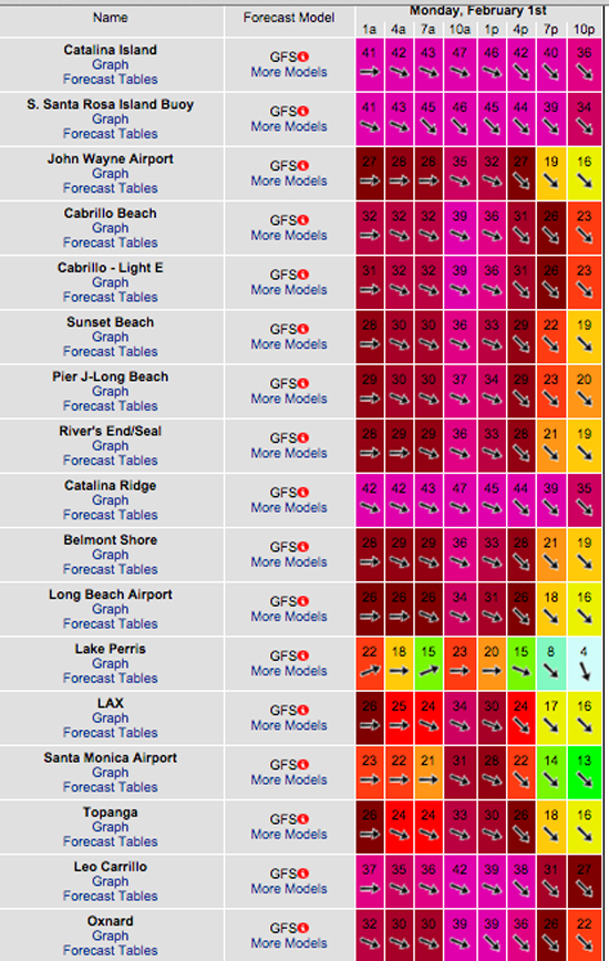
* Monday wind model projections… hold onto your hat!

______________________________________________________________________________
The current water temps Newport 58 degrees, Huntington 57 degrees, the South Bay showed as 62 degrees, Santa Monica 59 degrees and Malibu 59 degrees.
______________________________________________________________________________
I’ll be back on Wednesday with the latest scoop!
______________________________________________________________________________
