______________________________________________________________________________
LNF: SAND & FURY from LastNameFirst.tv on Vimeo.
______________________________________________________________________________
SOUTHERN CALIFORNIA SURF FORECAST UPDATED 5-29-15
______________________________________________________________________________
Follow us on Facebook Check it out!
______________________________________________________________________________
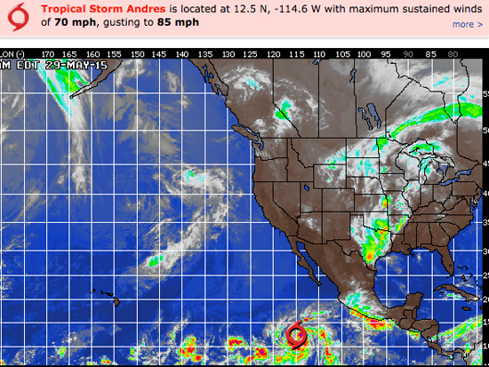
HURRICANE WATCH: Tropical Storm Andres is close to hurricane strength and will likely grow even stronger during the next 48 hours perhaps becoming a Category 2 hurricane by Sunday morning. Andres is located about 780 miles to the south-southwest of the southern tip of Baja California and continues to track west-northwest at 9 mph. Sustained winds are currently 70 mph and is not far from becoming the first hurricane of the 2015 Tropical Season in the East Pacific Basin. That ridge will likely restrengthen and turn Andres back more to the west this weekend.
We are also watching an area of showers and thunderstorms several hundred miles south-southwest of the Gulf of Tehuantepec. This tropical wave will track west-northwest this weekend though an environment somewhat more favorable for development. This tropical wave may become more organized during the next 48-72 hours

______________________________________________________________________________
Saturday morning we’ll see small pulses out of the South and NW that won’t add up to much more than waist high surf at the top spots.
Saturday
2015-05-30 Sat 02:31 AM 0.38 feet Low Tide
2015-05-30 Sat 03:52 AM Moonset
2015-05-30 Sat 05:44 AM Sunrise
2015-05-30 Sat 08:34 AM 3.62 feet High Tide
2015-05-30 Sat 01:43 PM 1.57 feet Low Tide
2015-05-30 Sat 05:17 PM Moonrise
2015-05-30 Sat 07:58 PM Sunset
2015-05-30 Sat 08:07 PM 5.54 feet High Tide
The conditions look okay early with variable 1-3 MPH breezes until 10AM and 9-11 MPH in the afternoon. The air temp tops out at 75 degrees.
______________________________________________________________________________
Sunday morning looks no better with lackluster waist high surf up and down the coast.
Sunday
2015-05-31 Sun 03:05 AM -0.04 feet Low Tide
2015-05-31 Sun 04:30 AM Moonset
2015-05-31 Sun 05:44 AM Sunrise
2015-05-31 Sun 09:14 AM 3.71 feet High Tide
2015-05-31 Sun 02:16 PM 1.66 feet Low Tide
2015-05-31 Sun 06:14 PM Moonrise
2015-05-31 Sun 07:59 PM Sunset
2015-05-31 Sun 08:36 PM 5.79 feet High Tide
The conditions look about the same with variable 1-2 MPH breezes until 10AM and 8-10 MPH in the afternoon. The air temp tops out at 72 degrees.
______________________________________________________________________________
Monday morning should starts off on the small side but… if everything goes as projected some scout sets from the Hurricane could start to show later in the day. The initial pulses look to roll in at a super steep 163-165 degree angle, (which is basically sideways), and will only visit the most exposed South facing breaks.
Nothing is etched in stone quite yet so check back on Sunday for the latest scoop.
Monday
2015-06-01 Mon 03:38 AM -0.39 feet Low Tide
2015-06-01 Mon 05:11 AM Moonset
2015-06-01 Mon 05:43 AM Sunrise
2015-06-01 Mon 09:54 AM 3.77 feet High Tide
2015-06-01 Mon 02:49 PM 1.74 feet Low Tide
2015-06-01 Mon 07:12 PM Moonrise
2015-06-01 Mon 08:00 PM Sunset
2015-06-01 Mon 09:07 PM 5.98 feet High Tide
The conditions look decent early with 1-3 MPH breezes out of the E/SE until 10AM and 10-12 MPH out of the West in the afternoon. There’s a 10% chance of rain and the air temp tops out at 73degrees.
______________________________________________________________________________
By Tuesday morning, if the models play out as planned, the most exposed South facing breaks should see fairly consistent head high to overhead surf from an agonizingly steep angle of 170-175 degrees. Many spots will receive little to no swell due to the severity of the angle. The OC and San O’ areas will do best.
Also a more liberally angled SW ground swell will move in from a 210-215 degree angle late in the day and should be good for some chest high plus bonus swell for Wednesday morning.
Tuesday
2015-06-02 Tue 04:14 AM -0.66 feet Low Tide
2015-06-02 Tue 05:43 AM Sunrise
2015-06-02 Tue 05:57 AM Moonset
2015-06-02 Tue 09:21 AM Full Moon
2015-06-02 Tue 10:35 AM 3.81 feet High Tide
2015-06-02 Tue 03:23 PM 1.84 feet Low Tide
2015-06-02 Tue 08:00 PM Sunset
2015-06-02 Tue 08:09 PM Moonrise
2015-06-02 Tue 09:40 PM 6.09 feet High Tide
The conditions look passable with variable 2-4 MPH breezes until 10AM and 9-12 MPH winds out of the West in the afternoon. There’s a 10% chance of rain and the air temp tops out at a comfortable 73 degrees.
______________________________________________________________________________
The current water temps Newport 63 degrees, Huntington 62 degrees, the South Bay showed as 63 degrees, Santa Monica 60 degrees and Malibu 59 degrees.
______________________________________________________________________________
I’ll be back on Sunday with the next update!
______________________________________________________________________________
