______________________________________________________________________________
[easyrotator]erc_4_1383497509[/easyrotator]
______________________________________________________________________________
While we’re bobbing, elbow to elbow, battling for chest high closeouts out at El Porto, these 4 guys are all alone, getting pitted on triple overhead waves, down in Indo at Kandui Surf Resort! Holy S$%t!
______________________________________________________________________________
SOUTHERN CALIFORNIA SURF FORECAST UPDATED 11-3-13
______________________________________________________________________________
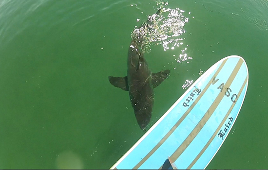
 If you haven’t seen the Video of the Great White Shark encounter, at El Porto, from 10-16-13
Check it out!
______________________________________________________________________________
FOUND -Churchill Surf fins & Hand plank found at Manhattan Beach Pier Nov 2.
Email [email protected] and identify to get them back
______________________________________________________________________________
HURRICANE WATCH 11-3-13
As of early this morning, T.D. E-18 has strengthened into Tropical Storm Sonia. The storm underwent an impressive strengthening phase overnight, evidenced by an expansive cluster of thunderstorms on the northwestern side of the storm.
Further intensification is likely over the next few hours as the storm begins to take a turn to the east, toward the Mexican mainland. Sonia’s rain bands will begin to impact the southern tip of the Baja Peninsula and western portions of Mexico beginning this afternoon.
______________________________________________________________________________
On Monday morning the NW wind swell will be the dominant energy, with the top West facing breaks seeing 8-10 second interval swell from a steep 310 degree angle. The ground swell will remain in the mix and the most exposed West facing breaks will be in the chest to head high range with a few larger sets on the medium to lower tides.
There’s a whopping 6.63 high tide at 8:50 AM so all bets are off for the mid morning session. It will drop dramatically through the day, culminating in a -0.79 low tide just before 4:00PM.
Monday
2013-11-04 Mon 02:34 AM 1.64 feet Low Tide
2013-11-04 Mon 06:16 AM Sunrise
2013-11-04 Mon 07:29 AM Moonrise
2013-11-04 Mon 08:50 AM 6.63 feet High Tide
2013-11-04 Mon 03:54 PM -0.79 feet Low Tide
2013-11-04 Mon 04:58 PM Sunset
2013-11-04 Mon 06:10 PM Moonset
2013-11-04 Mon 10:15 PM 4.28 feet High Tide
The conditions look fair with variable winds out of the S/SE in the 4-6 MPH zone until noon and 6-8 MPH winds out of the West in the afternoon. The air temp will top out at 64 degrees.
______________________________________________________________________________
Tuesday morning should have a little 8-10 second, NW wind swell left, but that will wallow in the waist to chest high range and also be influenced by a huge high tide at 9:30AM. The good news is that the time change will allow for the dawn patrollers to squeeze in a few rides before everything goes to sh#t.
It looks like we’ll also start to see some small but potent, 18-20 second ground swell start to show late in the day. This will be from a steep angle of 300-305 degrees so it will likely bypass all but the most exposed West facing breaks on Wednesday.
Tuesday
2013-11-05 Tue 03:12 AM 1.88 feet Low Tide
2013-11-05 Tue 06:17 AM Sunrise
2013-11-05 Tue 08:34 AM Moonrise
2013-11-05 Tue 09:30 AM 6.59 feet High Tide
2013-11-05 Tue 04:42 PM -0.76 feet Low Tide
2013-11-05 Tue 04:57 PM Sunset
2013-11-05 Tue 07:07 PM Moonset
2013-11-05 Tue 11:10 PM 4.09 feet High Tide
The conditions look excellent with NE/NNE winds in the 3-10 MPH zone all day long. The air temp will get up to 71 degrees as high pressure moves in and sets up camp for a couple days.
______________________________________________________________________________
Wednesday morning we will see continued NW energy in the waist to chest high range.
Once again a monster high tide of 6.36 feet at 10:15AM will cripple most spots mid morning but there will be a nice tidal push for the dawn patrollers.
Wednesday
2013-11-06 Wed 03:56 AM 2.17 feet Low Tide
2013-11-06 Wed 06:18 AM Sunrise
2013-11-06 Wed 09:34 AM Moonrise
2013-11-06 Wed 10:15 AM 6.36 feet High Tide
2013-11-06 Wed 04:56 PM Sunset
2013-11-06 Wed 05:36 PM -0.57 feet Low Tide
2013-11-06 Wed 08:09 PM Moonset
The conditions look excellent with winds, out of the NNE, in the 6-11 MPH zone until noon and 6-8 MPH winds out of the West in the afternoon. The air temp will hop up to a balmy 77 degrees on the sand.
______________________________________________________________________________
For Thursday morning we will see a continued combination of NW energy from a 295-305 degree angle, in the waist to chest high range.
Thursday
2013-11-07 Thu 12:14 AM 3.94 feet High Tide
2013-11-07 Thu 04:49 AM 2.47 feet Low Tide
2013-11-07 Thu 06:19 AM Sunrise
2013-11-07 Thu 10:30 AM Moonrise
2013-11-07 Thu 11:07 AM 5.95 feet High Tide
2013-11-07 Thu 04:55 PM Sunset
2013-11-07 Thu 06:36 PM -0.30 feet Low Tide
2013-11-07 Thu 09:14 PM Moonset
The conditions look good again with winds out of the NNE in the 2-8 MPH zone until 10AM and 8-10 MPH winds out of the West in the afternoon. The air temp will remain in the mid 70’s. degrees.
______________________________________________________________________________
The current water temps Newport 58 degrees, Huntington 61 degrees, the South Bay showed as 64 degrees, Santa Monica 62 degrees and Malibu 59 degrees.
______________________________________________________________________________
I’ll be back on Monday with next update!
______________________________________________________________________________
