______________________________________________________________________________
[easyrotator]erc_93_1383352156[/easyrotator]
______________________________________________________________________________
Today’s Slideshow is courtesy of Brian McStotts – McShots Archives
Check out Brian’s site to buy some killer prints!
______________________________________________________________________________
SOUTHERN CALIFORNIA SURF FORECAST UPDATED 11-1-13
______________________________________________________________________________
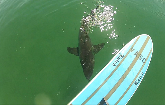
 If you haven’t seen the Video of the Great White Shark encounter, at El Porto, from 10-16-13
Check it out!
______________________________________________________________________________
HURRICANE WATCH 11-1-13
As of Friday evening, Tropical Depression EIGHTEEN-E remains about 300 miles west-southwest of Manzanillo, Mexico. The depression has sustained winds of 35 mph with higher gusts.
This system is over warm waters and an area with relatively low wind shear; therefore, there is a good chance that this depression will become Tropical Storm Sonia in the next 12-24 hours.
______________________________________________________________________________
Saturday morning we will see some new, NW energy, from a 295-305 degree angle, in the waist to chest high range.
Once again a monster high tide of 6.24 feet at 8:41AM will cripple most spots so expect some mushburgers for breakfast.
Saturday
2013-11-02 Sat 02:25 AM 1.30 feet Low Tide
2013-11-02 Sat 06:18 AM Moonrise
2013-11-02 Sat 07:14 AM Sunrise
2013-11-02 Sat 08:41 AM 6.24 feet High Tide
2013-11-02 Sat 03:29 PM -0.33 feet Low Tide
2013-11-02 Sat 05:33 PM Moonset
2013-11-02 Sat 05:59 PM Sunset
2013-11-02 Sat 09:40 PM 4.55 feet High Tide
The conditions look pretty good with variable winds, out of the East, in the 2-6 MPH zone until noon and 6-8 MPH winds out of the West in the afternoon. The air temp will dip down to 64 degrees.
______________________________________________________________________________
For Sunday morning we will see a continued combination of NW energy from a 295-305 degree angle, in the chest to shoulder high range.
Sunday
2013-11-03 Sun 01:58 AM 1.45 feet Low Tide
2013-11-03 Sun 04:49 AM New Moon
2013-11-03 Sun 06:15 AM Sunrise
2013-11-03 Sun 06:24 AM Moonrise
2013-11-03 Sun 08:14 AM 6.50 feet High Tide
2013-11-03 Sun 03:09 PM -0.65 feet Low Tide
2013-11-03 Sun 04:59 PM Sunset
2013-11-03 Sun 05:19 PM Moonset
2013-11-03 Sun 09:25 PM 4.45 feet High Tide
The conditions look tolerable with variable winds out of the East in the 2-6 MPH zone until noon and 6-8 MPH winds out of the West in the afternoon. The air temp will jump plummet to 64 degrees.
______________________________________________________________________________
On Monday morning the NW wind swell will be the dominant energy, with the top West facing breaks seeing 8-10 second interval swell from a steep 310 degree angle.
There’s a whopping 6.63 high tide at 8:50 AM so all bets are off for the mid morning session. It will drop dramatically through the day, culminating in a -0.79 low tide just before 4:00PM.
Monday
2013-11-04 Mon 02:34 AM 1.64 feet Low Tide
2013-11-04 Mon 06:16 AM Sunrise
2013-11-04 Mon 07:29 AM Moonrise
2013-11-04 Mon 08:50 AM 6.63 feet High Tide
2013-11-04 Mon 03:54 PM -0.79 feet Low Tide
2013-11-04 Mon 04:58 PM Sunset
2013-11-04 Mon 06:10 PM Moonset
2013-11-04 Mon 10:15 PM 4.28 feet High Tide
The conditions look good with variable winds out of the East in the 2-5 MPH zone until noon and 10-12 MPH winds out of the West in the afternoon. The air temp will top out at 64 degrees.
______________________________________________________________________________
Tuesday morning should have a little 8-10 second, NW wind swell left, but that will wallow in the waist high plus range and also be influenced by a huge high tide at 9:30AM. The good news is that the time change will allow for the dawn patrollers to squeeze in a few rides before everything goes to sh#t.
It looks like we’ll also start to see some small but potent, 18-20 second ground swell start to show late in the day. This will be from a steep angle of 300-305 degrees so it will likely bypass all but the most exposed West facing breaks on Wednesday.
Tuesday
2013-11-05 Tue 03:12 AM 1.88 feet Low Tide
2013-11-05 Tue 06:17 AM Sunrise
2013-11-05 Tue 08:34 AM Moonrise
2013-11-05 Tue 09:30 AM 6.59 feet High Tide
2013-11-05 Tue 04:42 PM -0.76 feet Low Tide
2013-11-05 Tue 04:57 PM Sunset
2013-11-05 Tue 07:07 PM Moonset
2013-11-05 Tue 11:10 PM 4.09 feet High Tide
The conditions look excellent with NE/NNE winds in the 5-10 MPH zone until noon and 9-11 MPH winds out of the West in the afternoon. The air temp will get up to 76 degrees.
______________________________________________________________________________
The current water temps Newport 58 degrees, Huntington 61 degrees, the South Bay showed as 64 degrees, Santa Monica 62 degrees and Malibu 59 degrees.
______________________________________________________________________________
I’ll be back on Sunday with next update!
______________________________________________________________________________
