______________________________________________________________________________
[easyrotator]erc_96_1383688654[/easyrotator]
Today’s Slideshow is courtesy of Ruben Pina – The South Bay 11-3-13 You can email Ruben at [email protected] to buy some killer prints!
______________________________________________________________________________
SOUTHERN CALIFORNIA SURF FORECAST UPDATED 11-5-13
______________________________________________________________________________
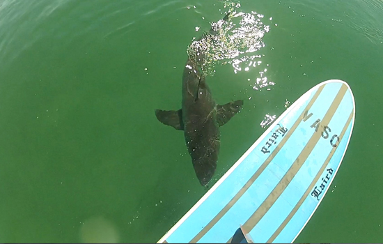
 If you haven’t seen the Video of the Great White Shark encounter, at El Porto, from 10-16-13
Check it out!
______________________________________________________________________________
FOUND -Churchill Surf fins & Hand plank found at Manhattan Beach Pier Nov 2.
Email [email protected] and identify to get them back
______________________________________________________________________________
HURRICANE WATCH 11-5-13
The Pacific Basin has become quiet once again. Strong vertical wind shear continues to dominate the upper-level wind structure. Current information suggests no support for tropical development through the next several days.
______________________________________________________________________________
For Wednesday morning we will see continued NW wind swell energy in the waist high range and some longer interval, 14-16 second ground swell from a steep 300-310 degree angle. This energy should put the top spots back into the chest to shoulder high zone on the sets. Due to the steep nature of this system, expect it to bypass all but the most exposed spots.
Once again a monster high tide of 6.36 feet at 10:15AM will cripple most spots mid morning, but there will be a nice tidal push for the dawn patrollers.
Wednesday
2013-11-06 Wed 03:56 AM 2.17 feet Low Tide
2013-11-06 Wed 06:18 AM Sunrise
2013-11-06 Wed 09:34 AM Moonrise
2013-11-06 Wed 10:15 AM 6.36 feet High Tide
2013-11-06 Wed 04:56 PM Sunset
2013-11-06 Wed 05:36 PM -0.57 feet Low Tide
2013-11-06 Wed 08:09 PM Moonset
The conditions look excellent with winds, out of the NNE, in the 3-11 MPH zone until noon, (stronger below the passes and canyons), and mild 2-6 MPH winds out of the West in the afternoon. The air temp will hop up to a balmy 77 degrees on the sand.
______________________________________________________________________________
For Thursday morning we will see a continued combination of NW energy from a 295-305 degree angle, in the waist to chest high range. It won’t be as consistent as Wednesday but there will still be some fun sets.
Thursday
2013-11-07 Thu 12:14 AM 3.94 feet High Tide
2013-11-07 Thu 04:49 AM 2.47 feet Low Tide
2013-11-07 Thu 06:19 AM Sunrise
2013-11-07 Thu 10:30 AM Moonrise
2013-11-07 Thu 11:07 AM 5.95 feet High Tide
2013-11-07 Thu 04:55 PM Sunset
2013-11-07 Thu 06:36 PM -0.30 feet Low Tide
2013-11-07 Thu 09:14 PM Moonset
The conditions look good again with winds out of the E/NNE in the 2-8 MPH zone until noon and 8-10 MPH winds out of the West in the afternoon. The air temp will climb up to a toasty 80 degrees.
______________________________________________________________________________
By Friday morning our mini run of swell will be on it’s last legs with inconsistent waist to waist high plus surf for the better West facing breaks.
Friday
2013-11-08 Fri 01:28 AM 3.93 feet High Tide
2013-11-08 Fri 06:02 AM 2.74 feet Low Tide
2013-11-08 Fri 06:20 AM Sunrise
2013-11-08 Fri 11:19 AM Moonrise
2013-11-08 Fri 12:11 PM 5.42 feet High Tide
2013-11-08 Fri 04:54 PM Sunset
2013-11-08 Fri 07:43 PM 0.00 feet Low Tide
2013-11-08 Fri 10:20 PM Moonset
The conditions will deteriorate slightly as high pressure heads out of town. The winds will be variable in the 1-3 MPH until 11AM and a relatively calm 6-8 MPH in the afternoon. The air temp will dip to 71 degrees.
______________________________________________________________________________
Saturday morning looks smaller with waist high surf for the top West facing breaks. Not too much to hang your hat on!
Saturday
2013-11-09 Sat 02:45 AM 4.13 feet High Tide
2013-11-09 Sat 06:21 AM Sunrise
2013-11-09 Sat 07:41 AM 2.80 feet Low Tide
2013-11-09 Sat 12:03 PM Moonrise
2013-11-09 Sat 01:32 PM 4.90 feet High Tide
2013-11-09 Sat 04:54 PM Sunset
2013-11-09 Sat 08:51 PM 0.27 feet Low Tide
2013-11-09 Sat 09:58 PM First Quarter
2013-11-09 Sat 11:25 PM Moonset
The conditions look fair with E/SE winds in the 3-4 MPH zone until 11AM and soft 3-5 MPH breezes out of the West until dark. The air temp will plummet to 65 degrees.
______________________________________________________________________________
For Sunday morning we’ll fair no better with feeble knee to waist high background swell.
Sunday
2013-11-10 Sun 03:52 AM 4.49 feet High Tide
2013-11-10 Sun 06:21 AM Sunrise
2013-11-10 Sun 09:27 AM 2.47 feet Low Tide
2013-11-10 Sun 12:44 PM Moonrise
2013-11-10 Sun 03:05 PM 4.53 feet High Tide
2013-11-10 Sun 04:53 PM Sunset
2013-11-10 Sun 09:54 PM 0.49 feet Low Tide
The conditions look pretty good with variable winds out of the East in the 1-3 MPH zone and 3-5 MPH West winds in the afternoon. The air temp will remain in the low to mid 60’s.
______________________________________________________________________________
The current water temps Newport 63 degrees, Huntington 63 degrees, the South Bay showed as 63 degrees, Santa Monica 62 degrees and Malibu 60 degrees.
______________________________________________________________________________
I’ll be back on Wednesday with the latest scoop!
______________________________________________________________________________
