______________________________________________________________________________
______________________________________________________________________________
SOUTHERN CALIFORNIA SURF FORECAST UPDATED 10-24-15
______________________________________________________________________________
Follow us on Facebook Check it out!
______________________________________________________________________________
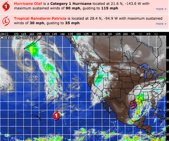
HURRICANE WATCH: What was once Hurricane Patricia has weakened as it traversed the rugged Mexican terrain, and it is now a tropical rainstorm. Despite this weakening, moisture from Patricia will continue to inundate parts of the south-central U.S.
Meanwhile, Hurricane Olaf was centered around 755 miles east-northeast of Hilo, Hawaii. Olaf has weakened to a Category 1 hurricane with a maximum-sustained wind of 90 mph. Olaf is moving to the northeast around 8 mph at this time. It will continue to produce very rough surf and seas across Hawaii over the next couple of days.

______________________________________________________________________________
Gentlemen, start your engines! This looks like it may be “THE YEAR” we’ve collectively been waiting for. We’re not even trick or treating yet and this has been the best October I can remember. Usually everyone stands around griping about perfect October conditions being wasted, flat surf, a lack of sand bars, or too many people in the line up… this October it seemed like every spot was breaking with a mix of swells from all angles and even a few Pumping, “Costco Free” days, (no offense Vince and Shrek).
As Bear said in Big Wednesday said, “That’s just the lemon next to the pie!” and it looks like by Wednesday we should start to see some crust being kneaded as 3 swells converge at once and light up every inch of the coast. That’s just the tip of the proverbial iceberg, so stay tuned and stay tubed!
______________________________________________________________________________
Monday morning looks promising with continued SW energy in the chest to shoulder high + range, (16-18 seconds from 205-210 degrees), and some fresh NW swell moving in and dishing up waist to chest high sets from a 300-310 degree angle.
Olaf swell will also be in the mix but not the dominant energy.
*See high tide time below in bold
Monday
2015-10-26 Mon 02:31 AM 0.49 feet Low Tide
2015-10-26 Mon 06:04 AM Moonset
2015-10-26 Mon 07:08 AM Sunrise
2015-10-26 Mon 08:45 AM 6.51 feet High Tide
2015-10-26 Mon 03:18 PM -0.49 feet Low Tide
2015-10-26 Mon 05:54 PM Moonrise
2015-10-26 Mon 06:07 PM Sunset
2015-10-26 Mon 09:29 PM 5.26 feet High Tide
The conditions look clean again with variable breezes in the 1-4 MPH zone until noon and 5-8 MPH out of the West in the afternoon. The air temp tops out at 81 degrees.
______________________________________________________________________________
Tuesday morning should be another fun day for waves with smaller NW swell in the waist high plus range and chest high + sets out of the SW from the ground swell and some bigger sets from Olaf, (12-14 second intervals from a very Westerly 245-255 degrees).
*See high tide time below in bold
Tuesday
2015-10-27 Tue 03:10 AM 0.73 feet Low Tide
2015-10-27 Tue 05:05 AM Full Moon
2015-10-27 Tue 07:08 AM Sunrise
2015-10-27 Tue 07:14 AM Moonset
2015-10-27 Tue 09:22 AM 6.75 feet High Tide
2015-10-27 Tue 04:04 PM -0.79 feet Low Tide
2015-10-27 Tue 06:06 PM Sunset
2015-10-27 Tue 06:40 PM Moonrise
2015-10-27 Tue 10:19 PM 5.04 feet High Tide
The conditions look good for the AM with variable breezes out of the East in the 1-5 MPH zone until noon and 5-7 MPH out of the West in the afternoon. The air temp backs down a hair to a still toasty 80 degrees.
______________________________________________________________________________
By Wednesday morning things should start to get real interesting with a combination of energy with
1. A SW ground swell, (14-16 second intervals from 210-215 degrees), which should be good for chest to head high surf at the exposed South facing breaks.
2. Hurricane Olaf swell, (13-15 second intervals from 255 degrees) shoulder to head high plus with larger sets for any beach receptive to that SW angle.
3. A beefy NW ground swell with muscle flexing 18-20 second intervals from a 300-310 degree angle and that will put the most exposed West facing breaks into the well Overhead zone!
Hard to see how each individual break will react, but it will be PUMPING somewhere! Happy Hunting and send in reports and pics. I will not name names or spots!
*See high tide time below in bold
Wednesday
2015-10-28 Wed 03:49 AM 1.08 feet Low Tide
2015-10-28 Wed 07:09 AM Sunrise
2015-10-28 Wed 08:23 AM Moonset
2015-10-28 Wed 10:01 AM 6.79 feet High Tide
2015-10-28 Wed 04:52 PM -0.85 feet Low Tide
2015-10-28 Wed 06:05 PM Sunset
2015-10-28 Wed 07:28 PM Moonrise
2015-10-28 Wed 11:12 PM 4.73 feet High Tide
The conditions look fair + for the AM with variable breezes out of the East in the 1-7 MPH zone until noon and 6-8 MPH out of the West in the afternoon. The air temp dips to 74 degrees.
______________________________________________________________________________
Thursday should be PUMPING again as that triple threat of swells continues to rock So Cal! The NW energy will be dominant, but the mix of swells could conjure up some wicked peaks if you find the right spot!
*See high tide time below in bold
Thursday
2015-10-29 Thu 04:30 AM 1.49 feet Low Tide
2015-10-29 Thu 07:10 AM Sunrise
2015-10-29 Thu 09:29 AM Moonset
2015-10-29 Thu 10:42 AM 6.62 feet High Tide
2015-10-29 Thu 05:43 PM -0.70 feet Low Tide
2015-10-29 Thu 06:04 PM Sunset
2015-10-29 Thu 08:20 PM Moonrise
The conditions look okay with variable breezes in the 1-4 MPH zone until noon and 9-12 MPH out of the West in the afternoon. The air temp tops out at 73 degrees.
______________________________________________________________________________
The current water temps Newport 71 degrees, Huntington 70 degrees, the South Bay showed as 72 degrees, Santa Monica 70 degrees and Malibu 70 degrees.
______________________________________________________________________________
I’ll be back on Monday with the next update!
______________________________________________________________________________
