______________________________________________________________________________
______________________________________________________________________________
SOUTHERN CALIFORNIA SURF FORECAST UPDATED 10-23-15
______________________________________________________________________________
Follow us on Facebook Check it out!
______________________________________________________________________________
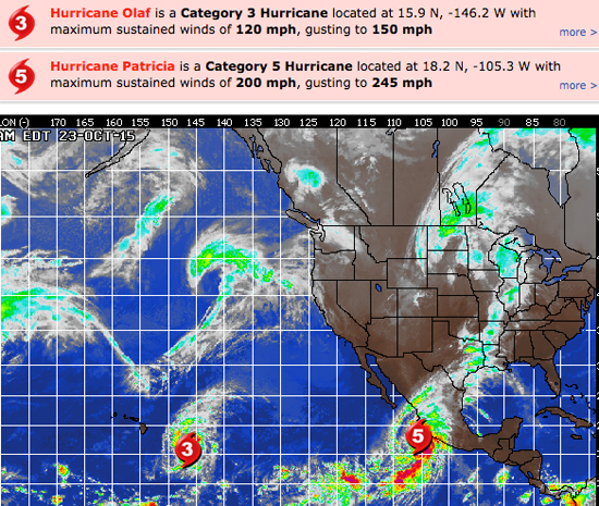
HURRICANE WATCH: Conditions along the Mexican coast will deteriorate quickly this afternoon into this evening as Patricia approaches. Patricia will bring devastating and extremely damaging wind gusts near or possibly in excess of 200 mph. Rainfall amounts will range from 6 to 12 inches with up to 20 inches possible locally. The greatest impacts will be felt at the immediate coastline and in the higher elevations just inland. This will result in life-threatening flash flooding and mudslides, as well as widespread power outages and severe damage to most structures. Not only will these strong winds bring catastrophic impacts, but a storm surge of up to 25 feet at the coast just east of the eye of the storm can also bring devastating flooding to coastal locations.
Once the storm moves inland tonight, it will weaken rapidly with winds by Saturday morning down to tropical storm force. Heavy rain will spread northeastward across Mexico Saturday and Saturday night. Eventually, some of the moisture will contribute to ongoing heavy rain across central and eastern Texas later in the weekend.
Meanwhile, Hurricane Olaf was centered over miles east-southeast of Hilo, Hawaii. Olaf remains a powerful Category 3 hurricane, with maximum sustained winds of 120 mph and higher gusts. Olaf is moving to the north at this time, but it is expected to turn toward the northeast later today through the weekend. This track will keep the system well east of Hawaii and therefore over the open waters of the Pacific where it will continue to weaken. While Olaf will pose no direct threat to land through the foreseeable future, it will continue to produce very rough surf and seas across Hawaii over the next few days.

______________________________________________________________________________
For Saturday morning we should see intermittent sets from Olaf and some new, small, but long interval SW swell, (20 seconds), fill in through the day. We should see waist to chest high plus sets in the AM and those will slowly increase in size and consistency as the day wears on.
Also in the mix will be some medium, (12-14 second interval), swell out of the NW from a steep 305-310 degree angle. The better West facing beaches should dish up waist to chest high surf.
*See high tide time below
Saturday
2015-10-24 Sat 01:12 AM 0.33 feet Low Tide
2015-10-24 Sat 03:46 AM Moonset
2015-10-24 Sat 07:06 AM Sunrise
2015-10-24 Sat 07:35 AM 5.59 feet High Tide
2015-10-24 Sat 01:46 PM 0.71 feet Low Tide
2015-10-24 Sat 04:29 PM Moonrise
2015-10-24 Sat 06:09 PM Sunset
2015-10-24 Sat 07:47 PM 5.30 feet High Tide
The conditions look fair + for the AM with variable breezes in the 1-3 MPH zone until noon and 6-10 MPH out of the West in the afternoon. The air temp tops out at 82 degrees.
______________________________________________________________________________
Sunday should be pretty good with continued SW ground swell from that same 200-210 degree angle. Most South facing breaks will see waist to chest high sets with the most exposed breaks in the San O’/OC area getting some larger waves mixed in later in the day.
NW wind swell will blend into the background with 10-12 second intervals from a 300-310 degree angle but still kick up some waist high sets for the better West facing beaches.
*See high tide time below
Sunday
2015-10-25 Sun 01:52 AM 0.35 feet Low Tide
2015-10-25 Sun 04:55 AM Moonset
2015-10-25 Sun 07:07 AM Sunrise
2015-10-25 Sun 08:09 AM 6.10 feet High Tide
2015-10-25 Sun 02:32 PM 0.03 feet Low Tide
2015-10-25 Sun 05:11 PM Moonrise
2015-10-25 Sun 06:08 PM Sunset
2015-10-25 Sun 08:39 PM 5.35 feet High Tide
The conditions look great with variable breezes out of the East in the 1-6 MPH zone until noon and 7-11 MPH out of the West in the afternoon. The air temp tops out at 84 degrees.
______________________________________________________________________________
Monday morning looks promising with continued SW energy in the chest to shoulder high + range, (16-18 seconds from 205-210 degrees), and some fresh NW swell moving in and dishing up waist to chest high sets from a 300-310 degree angle.
Olaf swell will also be in the mix but not the dominant energy.
*See high tide time below
Monday
2015-10-26 Mon 02:31 AM 0.49 feet Low Tide
2015-10-26 Mon 06:04 AM Moonset
2015-10-26 Mon 07:08 AM Sunrise
2015-10-26 Mon 08:45 AM 6.51 feet High Tide
2015-10-26 Mon 03:18 PM -0.49 feet Low Tide
2015-10-26 Mon 05:54 PM Moonrise
2015-10-26 Mon 06:07 PM Sunset
2015-10-26 Mon 09:29 PM 5.26 feet High Tide
The conditions look clean again with variable breezes out of the East in the 1-4 MPH zone until noon and 5-8 MPH out of the West in the afternoon. The air temp backs down to a still toasty 79 degrees.
______________________________________________________________________________
Tuesday morning should be another fun day for waves with smaller NW swell in the waist high plus range and chest high + sets out of the SW from the ground swell and some bigger sets from Olaf, (12-14 second intervals from a very Westerly 245-255 degrees).
*See high tide time below
Tuesday
2015-10-27 Tue 03:10 AM 0.73 feet Low Tide
2015-10-27 Tue 05:05 AM Full Moon
2015-10-27 Tue 07:08 AM Sunrise
2015-10-27 Tue 07:14 AM Moonset
2015-10-27 Tue 09:22 AM 6.75 feet High Tide
2015-10-27 Tue 04:04 PM -0.79 feet Low Tide
2015-10-27 Tue 06:06 PM Sunset
2015-10-27 Tue 06:40 PM Moonrise
2015-10-27 Tue 10:19 PM 5.04 feet High Tide
The conditions look fair with variable breezes in the 1-4 MPH zone until noon and 6-8 MPH out of the West in the afternoon. The air temp backs down to a still toasty 80 degrees.
______________________________________________________________________________
The current water temps Newport 71 degrees, Huntington 70 degrees, the South Bay showed as 73 degrees, Santa Monica 71 degrees and Malibu 70 degrees.
______________________________________________________________________________
I’ll be back on Sunday with the next update!
______________________________________________________________________________
