______________________________________________________________________________
[easyrotator]erc_55_1382818479[/easyrotator]
______________________________________________________________________________
Today’s Slideshow is courtesy of Brian McStotts – McShots Archives
Check out Brian’s site to buy some killer prints!
______________________________________________________________________________
SOUTHERN CALIFORNIA SURF FORECAST UPDATED 10-27-13
______________________________________________________________________________
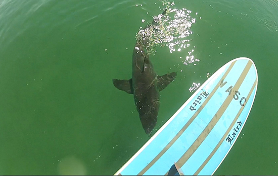
 If you haven’t seen the Video of the Great White Shark encounter, at El Porto, from 10-16-13
Check it out!
______________________________________________________________________________
HURRICANE WATCH 10-27-13
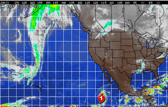
Raymond has become a hurricane again as it churns across the open waters of the eastern Pacific. This comes as no surprise. Raymond has been spinning in favorable conditions over the past 24 hours and further strengthening was expected.
An increase in thunderstorms around the center of the storm has been observed on satellite imagery on Sunday morning. An eye-wall is also beginning to take shape on microwave imagery, supporting the move to hurricane status.
This system will continue to remain over warm waters and in a low shear environment through Monday as it begins to shift to the north. Further strengthening is possible, but Raymond will remain a weak hurricane.
Weakening is likely late on Monday into Tuesday as Raymond encounters unfavorable conditions. A quick downgrade to a tropical storm is expected and eventually Raymond will turn into a tropical rainstorm towards the end of the week. No direct land impact is expected.
______________________________________________________________________________
Monday morning we will see a little bump in size, out of the NW, from a steep 305-310 degree angle. Nothing to get real excited about, but the top West facing beaches should see waist to chest high sets with 12-14 second intervals. The tide’s a little high at first light but that should help out the shape at beach breaks for the morning session.
Monday
2013-10-28 Mon 01:23 AM Moonrise
2013-10-28 Mon 06:37 AM 4.35 feet High Tide
2013-10-28 Mon 07:10 AM Sunrise
2013-10-28 Mon 12:23 PM 2.42 feet Low Tide
2013-10-28 Mon 02:34 PM Moonset
2013-10-28 Mon 05:50 PM 4.11 feet High Tide
2013-10-28 Mon 06:04 PM Sunset
The conditions look mediocre with variable winds, out of the S/SSE in the 6-8 MPH zone until 10AM and 9-11 MPH winds out of the West in the afternoon. The air temp will dip down to a chilly 61 degrees.
______________________________________________________________________________
For Tuesday morning looks similar with medium interval, 10-12 second interval, NW energy in the waist to maybe chest high zone. We’ll also see some shorter, 8-10 second interval wind swell mix in. Hurricane Raymond has been quite resilient the last few days too. Just when the experts pronounce him dead the blips on the monitor start chirping again. From the looks of things the best spots in the OC and San O’ areas should see waist to possibly chest high sets from a steep 170-175 degrees. *This remain hypothetical especially with a storm like Raymond but he is pegged to move North so keep your fingers crossed.
Tuesday
2013-10-29 Tue 12:20 AM 1.13 feet Low Tide
2013-10-29 Tue 02:19 AM Moonrise
2013-10-29 Tue 06:59 AM 4.70 feet High Tide
2013-10-29 Tue 07:11 AM Sunrise
2013-10-29 Tue 01:03 PM 1.85 feet Low Tide
2013-10-29 Tue 03:08 PM Moonset
2013-10-29 Tue 06:03 PM Sunset
2013-10-29 Tue 06:44 PM 4.27 feet High Tide
The conditions look decent with variable winds, out of the East, in the 2-4 MPH zone until 11 and 6-9 MPH winds out of the West in the afternoon. There is a 30% chance of rain and the air temp will remain in the low 60’s.
______________________________________________________________________________
For Wednesday morning we will see small, steeply angle, NW wind swell in the waist high plus range and possibly chest high sets, (cortesy of Raymond), from a steep 170-175 degrees. *This remain hypothetical especially with a storm like Raymond but he is pegged to move North so keep your fingers crossed.
Wednesday
2013-10-30 Wed 12:53 AM 1.12 feet Low Tide
2013-10-30 Wed 03:16 AM Moonrise
2013-10-30 Wed 07:11 AM Sunrise
2013-10-30 Wed 07:22 AM 5.08 feet High Tide
2013-10-30 Wed 01:39 PM 1.26 feet Low Tide
2013-10-30 Wed 03:41 PM Moonset
2013-10-30 Wed 06:02 PM Sunset
2013-10-30 Wed 07:31 PM 4.42 feet High Tide
The conditions look a bit iffy with onshore winds in the 3-5 MPH zone until noon and 8-11 MPH winds out of the West in the afternoon. The air temp will top out at 60 degrees.
______________________________________________________________________________
For Thursday morning we will see some new, 12-14 second interval swell, from a 295-300 degree angle, in the waist to possibly chest high range. We could also possibly see chest high sets, courtesy of Raymond), from a steep 170-175 degrees. *This remain hypothetical especially with a storm like Raymond but he is pegged to move North so keep your fingers crossed.
Thursday
2013-10-31 Thu 01:24 AM 1.14 feet Low Tide
2013-10-31 Thu 04:14 AM Moonrise
2013-10-31 Thu 07:12 AM Sunrise
2013-10-31 Thu 07:46 AM 5.48 feet High Tide
2013-10-31 Thu 02:14 PM 0.67 feet Low Tide
2013-10-31 Thu 04:15 PM Moonset
2013-10-31 Thu 06:01 PM Sunset
2013-10-31 Thu 08:14 PM 4.53 feet High Tide
The conditions look to improve with N/NNE winds in the 2-4 MPH zone until noon and 7-10 MPH winds out of the West in the afternoon. The air temp will jump up to 69 degrees.
______________________________________________________________________________
The current water temps Newport 63 degrees, Huntington 64 degrees, the South Bay showed as 64 degrees, Santa Monica 64 degrees and Malibu 61 degrees.
______________________________________________________________________________
I’ll be back on Monday with the next update
______________________________________________________________________________

