______________________________________________________________________________
[easyrotator]erc_84_1446059658[/easyrotator]
______________________________________________________________________________
Todays slide show is courtesy of Lucio Gomes of http://www.portosurfer.com If you see a good shot of yourself contact Lucio to buy a hi-res version for the living room!
______________________________________________________________________________
SOUTHERN CALIFORNIA SURF FORECAST UPDATED 10-28-15
______________________________________________________________________________
Follow us on Facebook Check it out!
______________________________________________________________________________
Well Wednesday didn’t really live up to expectations as the Olaf swell roared in with all the ferocity of a declawed Kitten and had trouble muscling through the high tide. There were a few decent sets but I’m sure everyone was hoping for a little bit more. Hopefully this new NW energy follows the script and starts tripping the local buoys soon!
______________________________________________________________________________
HURRICANE WATCH: The Eastern Pacific Ocean has finally quieted down. Olaf has lost tropical characteristics and is now considered a post-tropical storm. It is still producing sustained winds of 40 mph, but it will continue to weaken over the next day or two over the open waters of the eastern North Pacific.
______________________________________________________________________________
Thursday looks promising as that NW energy should be in play for the morning with a deepwater swell of nearly 4 feet at 16-18 second intervals. Although that doesn’t sound like much it should pack a wallop for the most exposed West facing beaches with the top, deep water breaks going head high to few feet overhead on the sets.
The Olaf energy, (although disappointing today), will continue to contribute to the mix and other SW pulses will remain relevant through the morning.
The perfect storm of swells I had hoped for didn’t follow the script and doesn’t look to play out for us as I had originally hoped, but there will be plenty of waves out there and this is only the beginning of our winter adventure!
*See high tide time below in bold
Thursday
2015-10-29 Thu 04:30 AM 1.49 feet Low Tide
2015-10-29 Thu 07:10 AM Sunrise
2015-10-29 Thu 09:29 AM Moonset
2015-10-29 Thu 10:42 AM 6.62 feet High Tide
2015-10-29 Thu 05:43 PM -0.70 feet Low Tide
2015-10-29 Thu 06:04 PM Sunset
2015-10-29 Thu 08:20 PM Moonrise
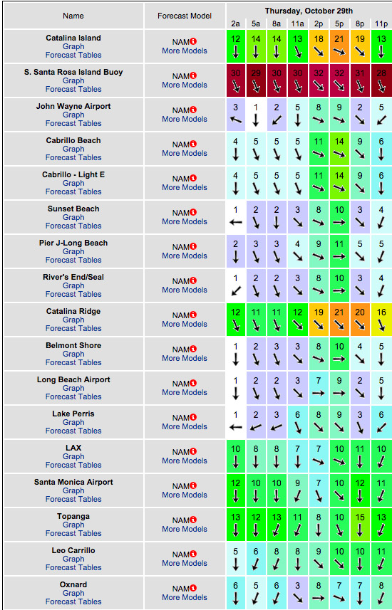
The conditions look questionable and rather than write it out here is a table from one of my most reliable wind models. It’s all over the place! The air temp tops out at 79 degrees.

______________________________________________________________________________
Friday morning should be another fun day for waves with continued size out of the NW swell in the head high + range with some larger sets at the top West facing beaches. We’ll also see pulses out of the SW from the ground swell and fading energy from Olaf.
There’s a nice tide push through the morning hours.
Friday
2015-10-30 Fri 12:10 AM 4.38 feet High Tide
2015-10-30 Fri 05:14 AM 1.96 feet Low Tide
2015-10-30 Fri 07:11 AM Sunrise
2015-10-30 Fri 10:31 AM Moonset
2015-10-30 Fri 11:26 AM 6.25 feet High Tide
2015-10-30 Fri 06:03 PM Sunset
2015-10-30 Fri 06:37 PM -0.38 feet Low Tide
2015-10-30 Fri 09:14 PM Moonrise
The conditions look interesting for the AM with breezes out of the N/NNE in the 3-13 MPH range until noon and 10-12 MPH out of the West in the afternoon. The air temp heats up to a toasty 83 degrees.
______________________________________________________________________________
Halloween morning looks fun with with smaller, fading NW swell in the chest high plus range in the AM and waist high + surf out of the SW.
Okay tide push early.
Saturday
2015-10-31 Sat 01:16 AM 4.07 feet High Tide
2015-10-31 Sat 06:04 AM 2.42 feet Low Tide
2015-10-31 Sat 07:12 AM Sunrise
2015-10-31 Sat 11:27 AM Moonset
2015-10-31 Sat 12:14 PM 5.73 feet High Tide
2015-10-31 Sat 06:02 PM Sunset
2015-10-31 Sat 07:38 PM 0.02 feet Low Tide
2015-10-31 Sat 10:10 PM Moonrise
The conditions look good for the AM with variable breezes out of the East in the 1-5 MPH zone until noon and 7-9 MPH out of the West in the afternoon. The air temp backs down a hair to 82 degrees.
______________________________________________________________________________
Sunday morning looks smaller but with all of the swell out there, there should be some waves lurking in the shadows. All swells will be on the fade for the AM, but some fresh, powerful, NW Ground swell will work it’s way down the line through the day. The energy will have 18-20 second intervals, (as did its predecessor), so expect some powerful lines at the better West facing breaks.
What a great October and an excellent way start our November!
Sunday
2015-11-01 Sun 01:35 AM 3.90 feet High Tide
2015-11-01 Sun 06:09 AM 2.83 feet Low Tide
2015-11-01 Sun 06:13 AM Sunrise
2015-11-01 Sun 11:18 AM Moonset
2015-11-01 Sun 12:12 PM 5.14 feet High Tide
2015-11-01 Sun 05:01 PM Sunset
2015-11-01 Sun 07:47 PM 0.39 feet Low Tide
2015-11-01 Sun 10:07 PM Moonrise
The conditions look good for the AM with variable breezes out of the E/SE in the 3-6 MPH zone until noon and 5-8 MPH out of the West in the afternoon. The air temp backs down 76 degrees.
______________________________________________________________________________
The current water temps Newport 70 degrees, Huntington 70 degrees, the South Bay showed as 71 degrees, Santa Monica 71 degrees and Malibu 68 degrees.
______________________________________________________________________________
I’ll be back on Thursday with the latest scoop!
______________________________________________________________________________
