______________________________________________________________________________
[easyrotator]erc_51_1411855866[/easyrotator]
Today’s Slideshow is courtesy of our friends at Kandui Surf Resort in Indo.
______________________________________________________________________________
SOUTHERN CALIFORNIA SURF FORECAST UPDATED 10-2-14
______________________________________________________________________________
SHARK UPDATE To see the latest shark updates follow us on Facebook Check it out!
______________________________________________________________________________

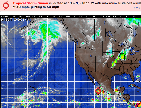
HURRICANE WATCH October 2nd, 2014 – While Simon is currently churning away from Mexico, the tropical storm should eventually turn and target Mexico’s Baja California.Tropical Storm Simon took shape early Thursday morning about 135 miles west-southwest of Manzanillo, Mexico.
While Simon is currently tracking to the west-northwest away from mainland Mexico, residents should not let their guard down. That includes those living or planning to visit Baja California next week. Downpours associated with Simon will continue to stream onto southwestern mainland Mexico through Friday, soaking the states of western Guerrero, western Michoacan, Colima, western Jalisco and Nayarit. At the same time, rough surf will create hazards for beachgoers and operators of small craft.
Through Saturday, Simon will continue to strengthen and reach hurricane status. The good news is that the heaviest rain and strongest winds will remain offshore during this time.
Simon should begin to weaken as the weekend comes to a close, but that is also when the storm will begin curving back to the northeast and toward Baja California.
Saturday, Simon will continue to strengthen and reach hurricane status. The good news is that the heaviest rain and strongest winds will remain offshore during this time.
Simon should begin to weaken as the weekend comes to a close, but that is also when the storm will begin curving back to the northeast and toward Baja California.
Once over mainland Mexico, the center of Simon will fall apart.
______________________________________________________________________________
By Friday morning the SW energy should be in fine form with shoulder to head high sets at the top South facing breaks. The winds look good, the tides are reasonable and any beach with a look at the SW should be firing.
Friday
2014-10-03 Fri 01:28 AM Moonset
2014-10-03 Fri 06:36 AM 4.27 feet High Tide
2014-10-03 Fri 06:50 AM Sunrise
2014-10-03 Fri 11:52 AM 2.36 feet Low Tide
2014-10-03 Fri 03:20 PM Moonrise
2014-10-03 Fri 05:51 PM 5.29 feet High Tide
2014-10-03 Fri 06:35 PM Sunset
The conditions look great with NE/NNE winds in the 2-10 MPH zone until the early afternoon and then those get up to 10-14 MPH out of the West in the afternoon. The air temp tops out at 88 degrees.
___________________________________________________________________________
By Saturday morning the SW energy should continue to dish up shoulder to head high sets and the wind and weather look awesome!
Saturday
2014-10-04 Sat 12:44 AM 0.17 feet Low Tide
2014-10-04 Sat 02:34 AM Moonset
2014-10-04 Sat 06:50 AM Sunrise
2014-10-04 Sat 07:13 AM 4.77 feet High Tide
2014-10-04 Sat 12:51 PM 1.70 feet Low Tide
2014-10-04 Sat 04:04 PM Moonrise
2014-10-04 Sat 06:34 PM Sunset
2014-10-04 Sat 06:53 PM 5.56 feet High Tide
The conditions look pretty good with N/NNE breezes in the 1-6 MPH zone until 11AM and then those bump up to 10-13 MPH in the afternoon. The air temp tops out at a steamy 84 degrees.
___________________________________________________________________________
For Sunday morning we’ll see another day of fun, SW energy in the chest to shoulder high range.
We’ll also yet another burst of SW energy start to move in through the day. Long intervals and a user friendly angle of 200-205 degrees.
The most exposed South facing beaches will get a whiff of Hurricane Simon swell too. This will be coming up the line at a severe, 165+ degree angle and only get into select beaches.
Looks like a nice run of energy and all the variables, on paper, look excellent!
Sunday
2014-10-05 Sun 01:27 AM 0.03 feet Low Tide
2014-10-05 Sun 03:42 AM Moonset
2014-10-05 Sun 06:51 AM Sunrise
2014-10-05 Sun 07:48 AM 5.29 feet High Tide
2014-10-05 Sun 01:43 PM 1.02 feet Low Tide
2014-10-05 Sun 04:47 PM Moonrise
2014-10-05 Sun 06:32 PM Sunset
2014-10-05 Sun 07:47 PM 5.73 feet High Tide
The conditions should be pretty good with light and variable breezes in the 2-3 MPH zone until 11AM and 8-10 MPH in the afternoon. The air temp dips slightly to 82 degrees.
___________________________________________________________________________
The current water temps Newport 67 degrees, Huntington 68 degrees, the South Bay showed as 70 degrees, Santa Monica 70 degrees and Malibu 66 degrees.
______________________________________________________________________________
I’ll be back on Friday with the next update!
______________________________________________________________________________
