_______________________________________________________________________________________________________
SOUTHERN CALIFORNIA SURF FORECAST UPDATED on 12-23-18
_______________________________________________________________________________________________________
The Biggest Wave of the Winter Contest is already seeing some serious contenders and it’s only December 21st!
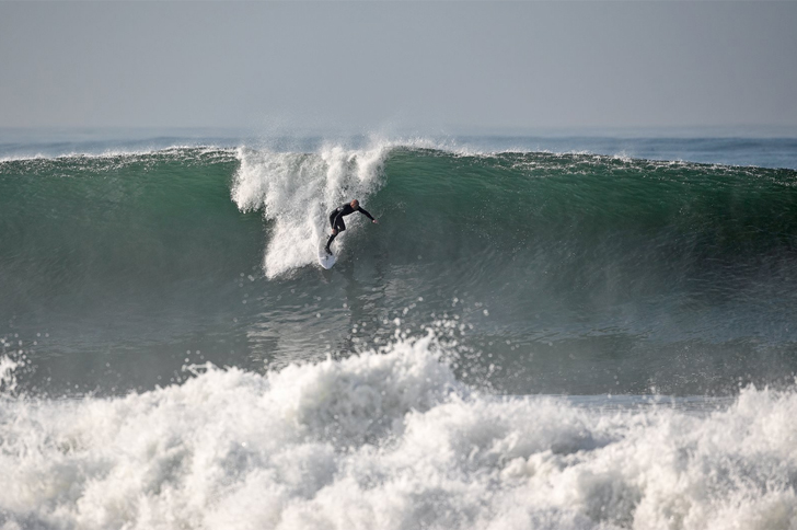
Matty Mohagan – The South Bay – December 2018 – Photo – Lucio Gomes
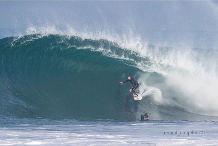
Alex Gray – The South Bay – December 2018 – Photo – Ron Lyon
_______________________________________________________________________________________________________
For Monday morning we will see another NW ground swell rumble into town. This energy will move in from a 295-310 degree angle, (16 second intervals), and fill in through the day. The top spots should see chest high + sets early and get up to head high to OH later in the morning.
Monster tide at 9:36: Tide zaps it around 9:30AM – 09:36 AM 6.76 feet High Tide
Monday
2018-12-24 Mon 03:22 AM 1.93 feet Low Tide
2018-12-24 Mon 06:56 AM Sunrise
2018-12-24 Mon 08:47 AM Moonset
2018-12-24 Mon 09:36 AM 6.76 feet High Tide
2018-12-24 Mon 04:50 PM Sunset
2018-12-24 Mon 04:52 PM -1.36 feet Low Tide
2018-12-24 Mon 07:21 PM Moonrise
2018-12-24 Mon 11:29 PM 4.11 feet High Tide
The conditions look good with 1-3 MPH offshore breezes until noon, (slightly stronger below passes and canyons), and 5-7 MPH out of the West in the afternoon. The air temp tops out 65 degrees.
______________________________________________________________________________________________________
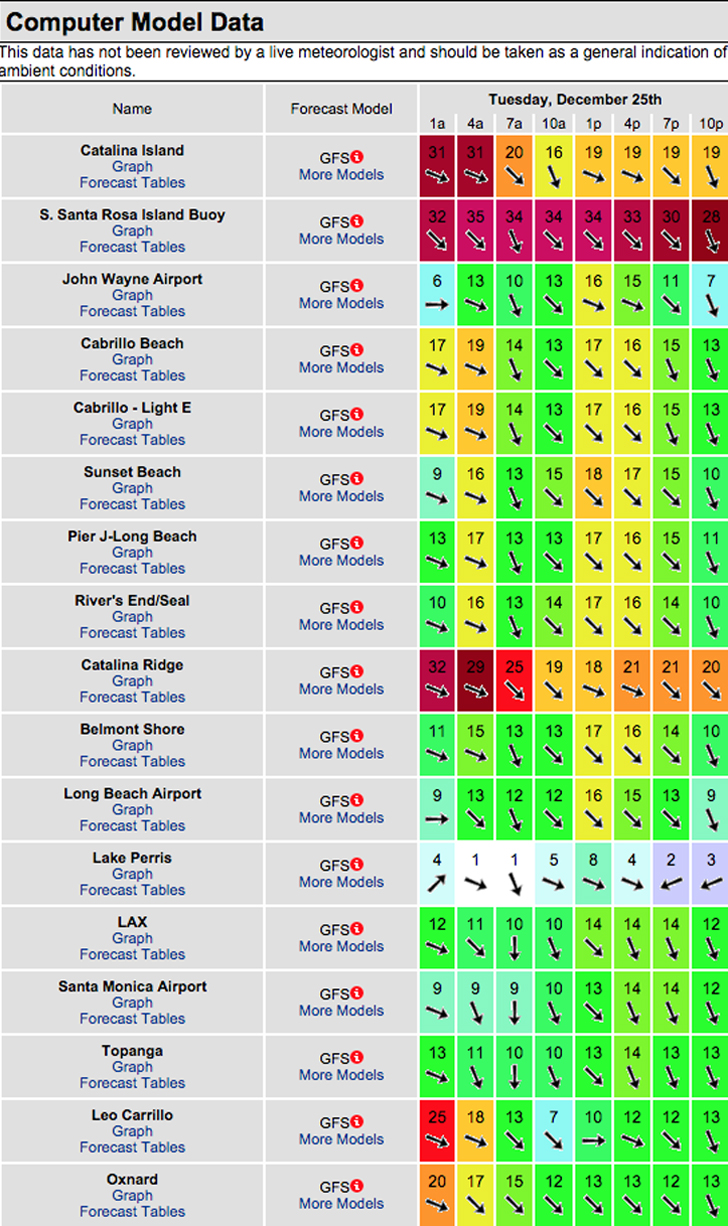
For Tuesday, Christmas morning we’ll see that NW ground swell dish up head high to OH + sets for the better West facing breaks from a 295-310 degree angle and 15-16 second intervals. That energy will be coupled with some short interval NW wind swell from 310 degrees. It looks like Santa has called for a stiff onshore wind scenario throughout the day and based on todays wind model it will be pretty blown out and choppy all day!
Nice tide push through the AM: 10:25 AM 6.38 feet High Tide
Tuesday
2018-12-25 Tue 04:14 AM 2.07 feet Low Tide
2018-12-25 Tue 06:57 AM Sunrise
2018-12-25 Tue 09:39 AM Moonset
2018-12-25 Tue 10:25 AM 6.38 feet High Tide
2018-12-25 Tue 04:51 PM Sunset
2018-12-25 Tue 05:41 PM -1.08 feet Low Tide
2018-12-25 Tue 08:30 PM Moonrise
The conditions look poor… See todays wind model run below. The air temp dips to 63 degrees.

______________________________________________________________________________________________________
For Wednesday morning things might be okay if the ocean surface cleans up overnight. The top West facing breaks will see a combo of the NW energy that should dish up head high to OH sets, (possibly even larger at the top spots).
Wednesday
2018-12-26 Wed 12:25 AM 4.16 feet High Tide
2018-12-26 Wed 05:16 AM 2.23 feet Low Tide
2018-12-26 Wed 06:57 AM Sunrise
2018-12-26 Wed 10:25 AM Moonset
2018-12-26 Wed 11:18 AM 5.80 feet High Tide
2018-12-26 Wed 04:51 PM Sunset
2018-12-26 Wed 06:33 PM -0.65 feet Low Tide
2018-12-26 Wed 09:39 PM Moonrise
The conditions look like could improve dramatically with N/NNE winds in the 2-4 MPH range until noon and 3-6 out of the SW in the afternoon. The air temp holds at 63 degrees.
______________________________________________________________________________________________________
For Thursday morning it looks like we’ll see continued NW energy in the Head High to OH range for the best West facing breaks.
Thursday
2018-12-27 Thu 01:25 AM 4.28 feet High Tide
2018-12-27 Thu 06:32 AM 2.33 feet Low Tide
2018-12-27 Thu 06:58 AM Sunrise
2018-12-27 Thu 11:05 AM Moonset
2018-12-27 Thu 12:20 PM 5.08 feet High Tide
2018-12-27 Thu 04:52 PM Sunset
2018-12-27 Thu 07:28 PM -0.15 feet Low Tide
2018-12-27 Thu 10:46 PM Moonrise
The conditions look to be great early with variable easterly breezes at 1-5 MPH until noon and blustery, 7-20 MPH onshore winds in the afternoon. The air temp holds at 63 degrees.
______________________________________________________________________________________________________
For Friday morning we’ll see leftover Head High + surf out of the NW.
Friday
2018-12-28 Fri 02:28 AM 4.49 feet High Tide
2018-12-28 Fri 06:58 AM Sunrise
2018-12-28 Fri 08:05 AM 2.24 feet Low Tide
2018-12-28 Fri 11:42 AM Moonset
2018-12-28 Fri 01:37 PM 4.34 feet High Tide
2018-12-28 Fri 04:52 PM Sunset
2018-12-28 Fri 08:27 PM 0.37 feet Low Tide
2018-12-28 Fri 11:50 PM Moonrise
The conditions look excellent with NE/NNE breezes at 7-18 MPH all day long. The air temp tops out at 61 degrees.
______________________________________________________________________________________________________
Water temps are as follows, (day of 4CAST update) and are as follows: Malibu 62 Santa Monica 62 South Bay 62, Huntington 59, Newport 62.
______________________________________________________________________________________________________
The next 4CAST will be posted on Wednesday! Happy Holidays!
______________________________________________________________________________________________________
ABOUT THE SWELLMAGNET FORECAST – One of the most exciting–and yet most challenging–aspects of surfing is the sheer variety of waves and weather conditions that affect the entire surfing experience. Any surfer who is interested in going beyond the most basic level of surfing will have to develop the ability to interpret waves and environmental conditions. This is important for ensuring both a safe and enjoyable experience.
The main difficulty lies in predicting how exactly the ocean and the environment will behave at any given time. One day, you could be riding four-footers all day and the next, you might be facing a glasslike surface with nary a ripple. Conditions can change drastically from day-to-day and even within the space of a couple of hours. To avoid wasted time and unproductive trips to the surf, it is essential to have access to reliable information on surf conditions.
Sites such as Swellmagnet.com offer up-to-the-minute surf reports that are essential to all California surfers. The company relies on an extensive network of surf cams and surf experts in order to monitor the precise surf conditions on any given day. All information is collated and analyzed by qualified surf specialists, with the resulting data being provided to the public via the Swellmagnet site.
Swellmagnet provides some of the best surf reports in the industry, with accurate and verifiable results gathered via an innovative system of surf condition monitors and detectors. Expert surf analysis is provided by the company’s team of highly experienced specialists, each with long years of experience monitoring and actually experiencing the full range of surf conditions. This combination of state-of-the-art technology and extensive practical experience ensures the highest quality and most accurate surf reports available.
For surfers who wish to take full advantage of the best that the California coast has to offer, the services provided by Swellmagnet are essential.


