_______________________________________________________________________________________________________
SOUTHERN CALIFORNIA SURF FORECAST UPDATED on 11-27-18
_______________________________________________________________________________________________________
HURRICANE WATCH
There are no tropical cyclones over the East Pacific Basin. While no development is expected over the next couple of days, an area of low pressure well south of Mexico has a small chance to become better organized heading into next week.
_______________________________________________________________________________________________________
For Wednesday morning we’re looking at some significant surf for the West facing breaks. This swell should peak in the AM with OH to WOH, (Well OverHead), sets and possibly some larger DOH widow maker waves at the most exposed breaks. I’m guessing that the South Bay Beach breaks may be a tough proposition with no other swell to cross things up, (and no sand bars to speak of), so the points, reefs and slightly sheltered South facing beaches will definitely be worth a look.
This energy or some slight variation of this swell should take us all the way into Sunday as the swell is slated to be on a Slooowww fade after Wednesday.
Wednesday
2018-11-30 Fri 04:19 AM 4.66 feet High Tide
2018-11-30 Fri 06:40 AM Sunrise
2018-11-30 Fri 10:03 AM 2.31 feet Low Tide
2018-11-30 Fri 01:04 PM Moonset
2018-11-30 Fri 03:30 PM 4.37 feet High Tide
2018-11-30 Fri 04:44 PM Sunset
2018-11-30 Fri 10:12 PM 0.41 feet Low Tide
The conditions look good for spots that can handle a SE/SSE direction with offshore/side shore breezes at 3-6 MPH until noon and 3-8 MPH out of the SW in the afternoon. The air temp dips to 66 degrees and there’s a 60% chance of rain.
______________________________________________________________________________________________________
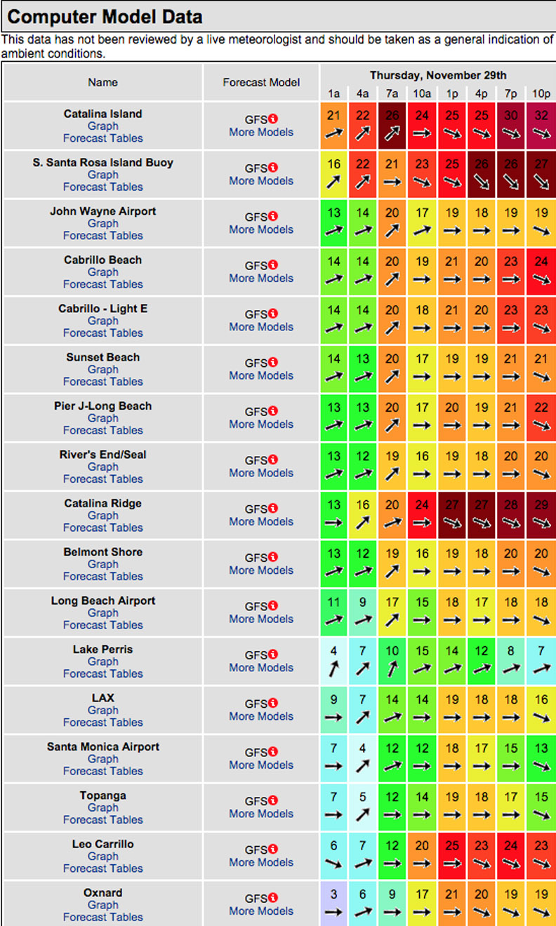
For Thursday morning we’ll see that NW energy continue to pump but unfortunately the winds are forecasted to be Shi#$y at best with… well, look at the projection below! The surf itself will be Large and In Charge with OH to DOH sets at the better West facing breaks.
With all this swell some of it will undoubtedly bleed into the lesser exposed beaches. The trick will be to find a wind sheltered break or a kelp laden spot that can smooth out the ripples. Regardless, the surf will be there!
Thursday
2018-11-29 Thu 03:22 AM 4.25 feet High Tide
2018-11-29 Thu 06:39 AM Sunrise
2018-11-29 Thu 08:25 AM 2.80 feet Low Tide
2018-11-29 Thu 12:26 PM Moonset
2018-11-29 Thu 01:58 PM 4.69 feet High Tide
2018-11-29 Thu 04:21 PM Last Quarter
2018-11-29 Thu 04:44 PM Sunset
2018-11-29 Thu 09:13 PM 0.17 feet Low Tide
2018-11-29 Thu 11:49 PM Moonrise
The conditions look piss poor on todays wind models. See above! The air temp plummets to 63 degrees and there’s a 100% chance of rain.
______________________________________________________________________________________________________
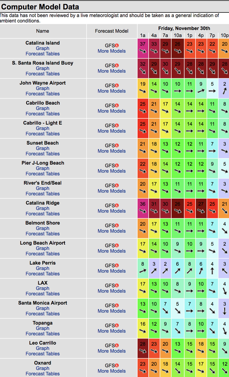
For Friday morning it looks like we’ll be plagued by onshore winds again. The surf will continue to hammer the best West facing beaches with OH to DOH sets in the AM and that will slowly taper off in the afternoon. The swell angle will be 290-300 degrees with 14-15 second intervals!
Once again… look for a wind protected area unless you’re an aerial specialist looking for onshore ramps!
Friday
2018-11-30 Fri 04:19 AM 4.66 feet High Tide
2018-11-30 Fri 06:40 AM Sunrise
2018-11-30 Fri 10:03 AM 2.31 feet Low Tide
2018-11-30 Fri 01:04 PM Moonset
2018-11-30 Fri 03:30 PM 4.37 feet High Tide
2018-11-30 Fri 04:44 PM Sunset
2018-11-30 Fri 10:12 PM 0.41 feet Low Tide
The conditions look crummy again with NW breezes at 6-10 MPH all day long. The air temp tops out at 64 degrees.
______________________________________________________________________________________________________
For Saturday morning we’ll see continued swell with head high to OH sets at the best West facing breaks. The conditions look iffy at best with early morning holding the most promise.
Saturday
2018-12-01 Sat 12:53 AM Moonrise
2018-12-01 Sat 05:05 AM 5.11 feet High Tide
2018-12-01 Sat 06:41 AM Sunrise
2018-12-01 Sat 11:17 AM 1.61 feet Low Tide
2018-12-01 Sat 01:39 PM Moonset
2018-12-01 Sat 04:44 PM Sunset
2018-12-01 Sat 04:53 PM 4.23 feet High Tide
2018-12-01 Sat 11:05 PM 0.65 feet Low Tide
The conditions look sketchy again with onshore breezes at 2-6 MPH until 8:00AM and 8-25 MPH out of the West throughout the rest of the day. The air temp tops out at 61 degrees and there’s a 50% chance of rain.
______________________________________________________________________________________________________
For Sunday morning we’ll have plenty of surf but the winds will do us no favors. The best West facing beaches should see head high to WOH sets through the morning. Things look messy all day long!
Sunday
2018-12-02 Sun 01:57 AM Moonrise
2018-12-02 Sun 05:45 AM 5.54 feet High Tide
2018-12-02 Sun 06:42 AM Sunrise
2018-12-02 Sun 12:14 PM 0.90 feet Low Tide
2018-12-02 Sun 02:13 PM Moonset
2018-12-02 Sun 04:44 PM Sunset
2018-12-02 Sun 06:03 PM 4.20 feet High Tide
2018-12-02 Sun 11:50 PM 0.91 feet Low Tide
The conditions look awful with 11-23 MPH breezes out of the West all day long. The air temp tops out at 60 degrees.
______________________________________________________________________________________________________
Water temps are as follows, (day of 4CAST update) and are as follows: Malibu 63 Santa Monica 65 South Bay 65, Huntington 61, Newport 66.
______________________________________________________________________________________________________
The next 4CAST will be posted on Thursday!
______________________________________________________________________________________________________
ABOUT THE SWELLMAGNET FORECAST – One of the most exciting–and yet most challenging–aspects of surfing is the sheer variety of waves and weather conditions that affect the entire surfing experience. Any surfer who is interested in going beyond the most basic level of surfing will have to develop the ability to interpret waves and environmental conditions. This is important for ensuring both a safe and enjoyable experience.
The main difficulty lies in predicting how exactly the ocean and the environment will behave at any given time. One day, you could be riding four-footers all day and the next, you might be facing a glasslike surface with nary a ripple. Conditions can change drastically from day-to-day and even within the space of a couple of hours. To avoid wasted time and unproductive trips to the surf, it is essential to have access to reliable information on surf conditions.
Sites such as Swellmagnet.com offer up-to-the-minute surf reports that are essential to all California surfers. The company relies on an extensive network of surf cams and surf experts in order to monitor the precise surf conditions on any given day. All information is collated and analyzed by qualified surf specialists, with the resulting data being provided to the public via the Swellmagnet site.
Swellmagnet provides some of the best surf reports in the industry, with accurate and verifiable results gathered via an innovative system of surf condition monitors and detectors. Expert surf analysis is provided by the company’s team of highly experienced specialists, each with long years of experience monitoring and actually experiencing the full range of surf conditions. This combination of state-of-the-art technology and extensive practical experience ensures the highest quality and most accurate surf reports available.
For surfers who wish to take full advantage of the best that the California coast has to offer, the services provided by Swellmagnet are essential.


