______________________________________________________________________________
[easyrotator]erc_26_1409526987[/easyrotator]
Today’s Slideshow is courtesy of Dave Waters – Newport Beach-The Wedge 8-26-14
Check out more pics
______________________________________________________________________________
SOUTHERN CALIFORNIA SURF FORECAST UPDATED 9-13-14
______________________________________________________________________________
SHARK UPDATE To see the latest shark updates follow us on Facebook Check it out!
______________________________________________________________________________
Okay took the red eye in from Peru last night and am ready to get back to work. Sorry for any lapse in service over the last 10 days. The forecast will one again be updated daily and I’ll take care of any and all camera issues that have arisen in my absence! Thanks for your patience!
______________________________________________________________________________

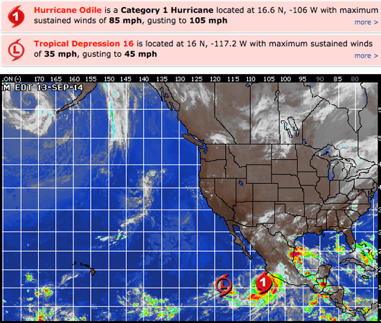
HURRICANE WATCH September 13th, 2014 – While there are two organized systems to watch in the East Pacific, the only system of consequence remains Hurricane Odile.
Hurricane Odile continues to parallel the southwestern coast of Mexico, some 200 miles offshore. The system is gradually gaining strength and significant impacts are expected to be minimal as the center of circulation should remain a couple hundred miles away from land.
Wind gusts to near 40 mph will be possible along the coast from Colima to Nayarit, including the state of Jalisco. Sustained tropical-storm force winds should remain offshore.
As Odile moves steadily northwestward it will pass close to the coast of Baja California late Sunday through early next week. Similar conditions are expected for the southern Baja based on the current track forecast… but if Odile tracks closer to the coast then wind gusts of 60 mph cannot be ruled out.
______________________________________________________________________________
Sunday morning looks small again with knee to waist high surf up and down the coast. The good news is that some LONG interval SW energy will creep into town late in the day from a 215-220 degree angle. We wont’t see much until very late in the day but should be in play for Monday morning.
Looks like another heat wave will start up and cook Southern California alive!
Sunday
2014-09-14 Sun 02:18 AM 3.69 feet High Tide
2014-09-14 Sun 06:36 AM Sunrise
2014-09-14 Sun 07:19 AM 2.32 feet Low Tide
2014-09-14 Sun 12:32 PM Moonset
2014-09-14 Sun 01:49 PM 5.16 feet High Tide
2014-09-14 Sun 07:01 PM Sunset
2014-09-14 Sun 09:19 PM 1.02 feet Low Tide
2014-09-14 Sun 11:14 PM Moonrise
The conditions look decent with variable winds in the 1-4 MPH zone until 11AM and then those bump up to 10-13 MPH in the afternoon. The air temp tops out at 87 degrees.
___________________________________________________________________________
Monday morning should see some 20+ second interval energy from a liberal 215-220 degrees. This should be good for some chest high plus sets at the better West facing breaks.
Monday
2014-09-15 Mon 04:08 AM 3.45 feet High Tide
2014-09-15 Mon 06:37 AM Sunrise
2014-09-15 Mon 08:31 AM 2.78 feet Low Tide
2014-09-15 Mon 01:25 PM Moonset
2014-09-15 Mon 03:02 PM 4.85 feet High Tide
2014-09-15 Mon 07:00 PM Sunset
2014-09-15 Mon 07:05 PM Last Quarter
2014-09-15 Mon 10:50 PM 1.02 feet Low Tide
The conditions look fair with variable winds in the 1-5 MPH zone until 11AM and then those pick up to 9-11 MPH in the afternoon. The air temp tops out at 86
___________________________________________________________________________
Tuesday morning should have some fun sets out of the SW as that long period swell from an angle of 215-220 degrees peaks in the morning. This should put the better South facing beaches in the chest high plus zone.
Looks like Odile energy should work it’s way into the mix as well with potential for a little size at the super exposed South facing beaches. I’ll have a good look at all the models tomorrow so I can have a more comprehensive forecast. Stay tuned!
Tuesday
2014-09-16 Tue 12:03 AM Moonrise
2014-09-16 Tue 05:57 AM 3.61 feet High Tide
2014-09-16 Tue 06:37 AM Sunrise
2014-09-16 Tue 10:18 AM 2.95 feet Low Tide
2014-09-16 Tue 02:14 PM Moonset
2014-09-16 Tue 04:28 PM 4.74 feet High Tide
2014-09-16 Tue 06:59 PM Sunset
The conditions look okay with light onshore winds in the 1-3 MPH zone until 10AM and then those pick up to 10-12 MPH in the afternoon. The air temp tops out at scorching 88 degrees.
___________________________________________________________________________
The current water temps Newport 70 degrees, Huntington 68 degrees, the South Bay showed as 74 degrees, Santa Monica 71 degrees and Malibu 70 degrees.
______________________________________________________________________________
I’ll be back on Sunday with the next update!
______________________________________________________________________________
