______________________________________________________________________________
[easyrotator]erc_51_1411855866[/easyrotator]
Today’s Slideshow is courtesy of our friends at Kandui Surf Resort in Indo.
______________________________________________________________________________
SOUTHERN CALIFORNIA SURF FORECAST UPDATED 9-30-14
______________________________________________________________________________
SHARK UPDATE To see the latest shark updates follow us on Facebook Check it out!
______________________________________________________________________________

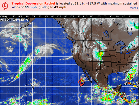
HURRICANE WATCH September 30th, 2014 – Rachel has weakened to a tropical depression as it remains nearly stationary over the open waters of the Pacific. Rachel will continue to weaken over the next 12 to 24 hours and will eventually dissipate completely later today. Look for enhanced surf and rip currents along the western coast of the Baja Peninsula.
A cluster of disorganized weather a few hundred miles south of the Gulf of Tehuantepec is expected to become gradually better organized as it tracks northwestward this week. While imminent development is not expected over the next 24-48 hours, an acquisition of tropical characteristics is looking likely later in the upcoming week.`
______________________________________________________________________________
Wednesday morning holds a little more promise as a combination of small, steeply angled, NW wind swell moves in from a 310 degree angle with 8-10 second periods.
We’ll also have see a 2 foot, deep water, SW swell roll in from a liberal angle of 220 degrees. Nothing too impressive, but there should be some fun little sets in the waist high plus range for the better South facing beaches. The wind swell should serve up waist high peaks for the top West facing beaches.
Wednesday
2014-10-01 Wed 04:38 AM 3.44 feet High Tide
2014-10-01 Wed 06:48 AM Sunrise
2014-10-01 Wed 08:31 AM 3.00 feet Low Tide
2014-10-01 Wed 12:33 PM First Quarter
2014-10-01 Wed 01:41 PM Moonrise
2014-10-01 Wed 03:06 PM 4.93 feet High Tide
2014-10-01 Wed 06:38 PM Sunset
2014-10-01 Wed 10:52 PM 0.70 feet Low Tide
The conditions should be a transition day as we plunge into our next heatwave on Thursday. Winds will be out of the SE/SSE in the 3-5 MPH zone until 11AM and remain a light 6-8 MPH in the afternoon. The air temp starts hits the 76 degree mark.
___________________________________________________________________________
For Thursday morning both swells will be on the decline, offering up waist high sets for the both the South and West facing breaks.
More exciting is that the a new, stronger, SW swell will fill in through the day. This one will have long intervals and move in from a 200-210 degree angle. Bt the end of the day the better South facing breaks should go shoulder to head high with some larger sets at the best South facing breaks.
Thursday
2014-10-02 Thu 12:25 AM Moonset
2014-10-02 Thu 05:51 AM 3.81 feet High Tide
2014-10-02 Thu 06:49 AM Sunrise
2014-10-02 Thu 10:29 AM 2.86 feet Low Tide
2014-10-02 Thu 02:32 PM Moonrise
2014-10-02 Thu 04:36 PM 5.04 feet High Tide
2014-10-02 Thu 06:36 PM Sunset
2014-10-02 Thu 11:54 PM 0.41 feet Low Tide
The conditions look good with NE/NNE winds in the in the 3-10 MPH zone through most of the day with stronger gusts below the passes and canyons. The air temp jumps up to 86 degrees.
___________________________________________________________________________
By Friday morning the SW energy should be in fine form with shoulder to head high sets at the top South facing breaks. The winds look good, the tides are reasonable and any beach with a look at the SW should be firing.
Friday
2014-10-03 Fri 01:28 AM Moonset
2014-10-03 Fri 06:36 AM 4.27 feet High Tide
2014-10-03 Fri 06:50 AM Sunrise
2014-10-03 Fri 11:52 AM 2.36 feet Low Tide
2014-10-03 Fri 03:20 PM Moonrise
2014-10-03 Fri 05:51 PM 5.29 feet High Tide
2014-10-03 Fri 06:35 PM Sunset
The conditions look great with NE/NNE winds in the 2-10 MPH zone until the early afternoon and then those get up to 10-14 MPH out of the West in the afternoon. The air temp tops out at 89 degrees.
___________________________________________________________________________
By Saturday morning the SW energy should continue to dish up shoulder to head high sets and the wind and weather look awesome!
Saturday
2014-10-04 Sat 12:44 AM 0.17 feet Low Tide
2014-10-04 Sat 02:34 AM Moonset
2014-10-04 Sat 06:50 AM Sunrise
2014-10-04 Sat 07:13 AM 4.77 feet High Tide
2014-10-04 Sat 12:51 PM 1.70 feet Low Tide
2014-10-04 Sat 04:04 PM Moonrise
2014-10-04 Sat 06:34 PM Sunset
2014-10-04 Sat 06:53 PM 5.56 feet High Tide
The conditions look pretty good with N/NNE breezes in the 1-6 MPH zone until 11AM and then those bump up to 10-13 MPH in the afternoon. The air temp tops out at a steamy 89 degrees.
___________________________________________________________________________
For Sunday morning we’ll see another day of fun, SW energy in the chest to shoulder high range. Looks like a nice run of energy and all the variable, on paper, look excellent!
Sunday
2014-10-05 Sun 01:27 AM 0.03 feet Low Tide
2014-10-05 Sun 03:42 AM Moonset
2014-10-05 Sun 06:51 AM Sunrise
2014-10-05 Sun 07:48 AM 5.29 feet High Tide
2014-10-05 Sun 01:43 PM 1.02 feet Low Tide
2014-10-05 Sun 04:47 PM Moonrise
2014-10-05 Sun 06:32 PM Sunset
2014-10-05 Sun 07:47 PM 5.73 feet High Tide
The conditions should be pretty good with light and variable breezes in the 2-3 MPH zone until 11AM and 8-10 MPH in the afternoon. The air temp dips slightly to 84 degrees.
___________________________________________________________________________
The current water temps Newport 68 degrees, Huntington 66 degrees, the South Bay showed as 70 degrees, Santa Monica 67 degrees and Malibu 64 degrees.
______________________________________________________________________________
I’ll be back on Wednesday with the next update!
______________________________________________________________________________
