______________________________________________________________________________
[easyrotator]erc_51_1411855866[/easyrotator]
Today’s Slideshow is courtesy of our friends at Kandui Surf Resort in Indo.
______________________________________________________________________________
SOUTHERN CALIFORNIA SURF FORECAST UPDATED 9-27-14
______________________________________________________________________________
SHARK UPDATE To see the latest shark updates follow us on Facebook Check it out!
______________________________________________________________________________

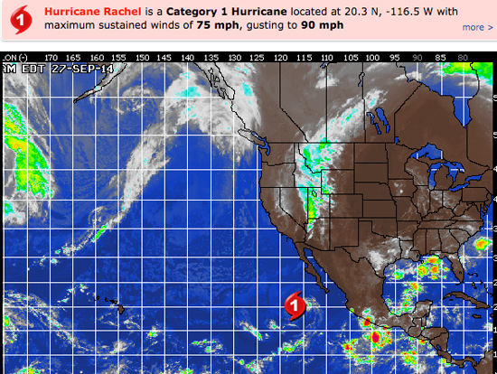
HURRICANE WATCH September 27th, 2014 – Rachel has become the season’s twelfth hurricane as she spins across the open waters of the eastern Pacific Ocean about 450 miles from Cabo San Lucas. Movement is toward the north-northwest at 8 mph with maximum sustained winds of 75 mph.
Satellite imagery from Saturday afternoon shows Rachel displaying a rather small but tightly wound circulation with even some semblance of an eye trying to establish itself within the center of the storm. Some additional strengthening is expected through the rest of the weekend, and Rachel should hold onto hurricane status into Sunday due to favorable enough environmental conditions.
Rachel is expected to drift northwestward through Monday, and then take a more west or southwest drift through next week. The storm will encounter somewhat cooler waters as it takes this path, and gradual weakening is expected during the upcoming week. Outside of some uptick in surf and rip currents across the western coast of Baja California, no direct impacts to land are expected from Rachel.
Elsewhere, a cluster of disorganized convection a few hundred miles south of Guatemala is expected to gradually get better organized as it tracks eastward through the upcoming week. While imminent development is not expected over the next 24-48 hours, an acquisition of tropical characteristics is looking likely later in the upcoming week.
______________________________________________________________________________
By Sunday morning the NW energy will be on the fade. The morning session should see waist to chest high sets with some larger sneaker sets for the exposed West facing beaches.
The wind swell should be in the waist high plus zone.
Looks like a decent tide push through he morning hours so if the winds behave themselves it should be okay!
Sunday
2014-09-28 Sun 12:15 AM 3.94 feet High Tide
2014-09-28 Sun 05:28 AM 2.04 feet Low Tide
2014-09-28 Sun 06:46 AM Sunrise
2014-09-28 Sun 10:53 AM Moonrise
2014-09-28 Sun 11:52 AM 5.36 feet High Tide
2014-09-28 Sun 06:42 PM Sunset
2014-09-28 Sun 07:01 PM 0.87 feet Low Tide
2014-09-28 Sun 09:41 PM Moonset
The conditions look a little better than originally expected with variable winds out of the E/SE in the 3-6 MPH zone until 11AM and then those bump up to 10-12 MPH in the afternoon. The air temp tops out at 72 degrees.
___________________________________________________________________________
By Monday morning that NW energy will be all but gone with just some minor NW wind swell lingering the background. I’ll have a look at things again tomorrow but for now it’s screaming “knee to waist high”, for the top West facing breaks.
Monday
2014-09-29 Mon 01:17 AM 3.57 feet High Tide
2014-09-29 Mon 06:02 AM 2.41 feet Low Tide
2014-09-29 Mon 06:47 AM Sunrise
2014-09-29 Mon 11:51 AM Moonrise
2014-09-29 Mon 12:37 PM 5.21 feet High Tide
2014-09-29 Mon 06:40 PM Sunset
2014-09-29 Mon 08:10 PM 0.95 feet Low Tide
2014-09-29 Mon 10:30 PM Moonset
The conditions look so so with variable winds, out of the South, in the 1-4 MPH zone until 11AM and then those bump up to 10-12 MPH in the afternoon. The air temp tops out at 74 degrees.
___________________________________________________________________________
By Tuesday morning should see more of the same with just small background swell out of the NW.
It does, however, look like we’ll see some fresh longer interval SW swell start to fill in through the day.
Tuesday
2014-09-30 Tue 02:48 AM 3.34 feet High Tide
2014-09-30 Tue 06:47 AM Sunrise
2014-09-30 Tue 06:54 AM 2.76 feet Low Tide
2014-09-30 Tue 12:47 PM Moonrise
2014-09-30 Tue 01:39 PM 5.03 feet High Tide
2014-09-30 Tue 06:39 PM Sunset
2014-09-30 Tue 09:33 PM 0.91 feet Low Tide
2014-09-30 Tue 11:25 PM Moonset
The conditions look pretty good with N/NE breezes in the 1-5 MPH zone until 11AM and then those bump up to 9-11 MPH in the afternoon. The air temp tops out at 75 degrees.
___________________________________________________________________________
Wednesday morning should see that SW energy hit it’s peak. I’ll dig a bit deeper tomorrow and bring you all the latest.
Wednesday
2014-10-01 Wed 04:38 AM 3.44 feet High Tide
2014-10-01 Wed 06:48 AM Sunrise
2014-10-01 Wed 08:31 AM 3.00 feet Low Tide
2014-10-01 Wed 12:33 PM First Quarter
2014-10-01 Wed 01:41 PM Moonrise
2014-10-01 Wed 03:06 PM 4.93 feet High Tide
2014-10-01 Wed 06:38 PM Sunset
2014-10-01 Wed 10:52 PM 0.70 feet Low Tide
The conditions look pretty good with variable winds, out of the East, in the 3-5 MPH zone until 11AM and then those bump up to 8-10 MPH in the afternoon. It looks like another heat wave headed our way through the week as the air temp jumps up to 79 degrees.
___________________________________________________________________________
The current water temps Newport 65 degrees, Huntington 67 degrees, the South Bay showed as 71 degrees, Santa Monica 70 degrees and Malibu 63 degrees.
______________________________________________________________________________
I’ll be back on Sunday with the next update!
______________________________________________________________________________
