_______________________________________________________________________________________________________
SOUTHERN CALIFORNIA SURF FORECAST UPDATED 4-24-16
_______________________________________________________________________________________________________
If you are having problems getting the streams please try using the “Chrome Browser”. Android users that are having problems will need to download the “Puffin Browser”. Click here for troubleshooting tips! Or feel free to email us for technical support contact us
_______________________________________________________________________________________________________
Oh Damn… it was pumping out front this morning with OH to well OH sets, but it wasn’t the size that made it tough… the waves just never stopped and there were zero traces of the user friendly channels we enjoyed all winter. I surfed plenty of sizeable days this season and this was the first time I was submissively sent back to the beach to start over again.
I tried for a solid half hour, (6-630AM) and got my ass handed to me. On my second attempt I got blasted so hard on one duck dive that it ripped the board out of my hands, violently removed my hood, (gone now, never found), and then pinned me to the bottom for about 10 seconds! This only made me more determined and I was finally able to puncture through to the outside and get some good waves!
Never underestimate Mother Nature… as soon as you think you have it wired she will surely give you a humbling smack down. I readily acknowledge to Mother Nature that “I don’t have it wired! BUT, I didn’t let you win completely”!
_______________________________________________________________________________________________________
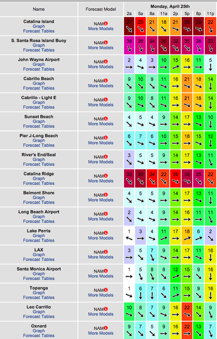
For Monday morning we will have tons of surf but the conditions are highly questionable. A combination of NW ground swell and NW wind swell will put the top West facing breaks into the OH to well OH zone with some DOH widow makers mixed in.
The energy will be coming from a steep 300-310 degree angle and mostly 8-10 second intervals. Judging by todays meaty surf it will be super consistent and not for the faint of heart.
Monday
2016-04-25 Mon 06:08 AM 0.09 feet Low Tide
2016-04-25 Mon 06:10 AM Sunrise
2016-04-25 Mon 08:39 AM Moonset
2016-04-25 Mon 12:30 PM 3.37 feet High Tide
2016-04-25 Mon 05:12 PM 2.07 feet Low Tide
2016-04-25 Mon 07:33 PM Sunset
2016-04-25 Mon 10:47 PM Moonrise
2016-04-25 Mon 11:31 PM 4.98 feet High Tide
The conditions are iffy… lots of wind in the mix and the models have been flip-flopping so here’s the latest projections below. The air temp tops out at 69 degrees.

_______________________________________________________________________________________________________
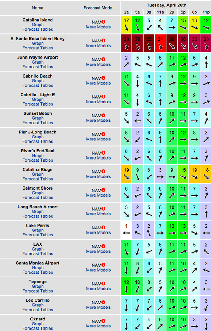
Tuesday should be smaller but there will be plenty of meat left on that bone. The West facing breaks will be in the head high to OH zone in the AM and that will slowly back down during the day.
Intervals and angles remain about the same. Wind speed and direction will be the question but the waves will be there for sure.
Tuesday
2016-04-26 Tue 06:09 AM Sunrise
2016-04-26 Tue 06:53 AM 0.24 feet Low Tide
2016-04-26 Tue 09:25 AM Moonset
2016-04-26 Tue 01:29 PM 3.15 feet High Tide
2016-04-26 Tue 05:43 PM 2.37 feet Low Tide
2016-04-26 Tue 07:34 PM Sunset
2016-04-26 Tue 11:38 PM Moonrise
The conditions look questionable again… see below for details. The air temp bumps up a hair to 70 degrees.

_______________________________________________________________________________________________________
By Wednesday morning the swell should be smaller and more manageable with 10-12 second interval energy out of the NW from that same 300-310 degrees. We’re anticipating chest to shoulder high wind swell for the exposed West facing beaches. Once again, IF the winds ease up it should be good for the AM.
Wednesday
2016-04-27 Wed 12:07 AM 4.75 feet High Tide
2016-04-27 Wed 06:08 AM Sunrise
2016-04-27 Wed 07:48 AM 0.39 feet Low Tide
2016-04-27 Wed 10:15 AM Moonset
2016-04-27 Wed 02:49 PM 3.05 feet High Tide
2016-04-27 Wed 06:27 PM 2.66 feet Low Tide
2016-04-27 Wed 07:35 PM Sunset
The conditions should be a little better with SE breezes at 3-5 MPH until 10AM and then some heavy gust whip into town at 16-30 MPH in the afternoon. Hold on to your hat! The air temp tops out at 68 degrees.
_______________________________________________________________________________________________________
Thursday should have more size as the NW swell holds and the NW wind swell increases. The best West facing breaks should see chest to head high plus surf with some bigger sets. Once again, the wind models are having trouble digesting what’s happening so stay tuned or just keep playing the guessing game!
Thursday
2016-04-28 Thu 12:26 AM Moonrise
2016-04-28 Thu 12:56 AM 4.49 feet High Tide
2016-04-28 Thu 06:07 AM Sunrise
2016-04-28 Thu 08:55 AM 0.49 feet Low Tide
2016-04-28 Thu 11:09 AM Moonset
2016-04-28 Thu 04:23 PM 3.17 feet High Tide
2016-04-28 Thu 07:35 PM Sunset
2016-04-28 Thu 07:56 PM 2.88 feet Low Tide
The conditions might be okay with variable 2-6 MPH breezes until 10AM or so and 8-14 MPH out of the West in the afternoon. The air temp dips to 67 degrees.
_______________________________________________________________________________________________________
Water Temps: are as follows – Malibu 56, Santa Monica 59, Hermosa 65, Huntington 59 & Newport 61 degrees.
_______________________________________________________________________________________________________
I’ll be back on Monday with the next update!
______________________________________________________________________________________________________
