______________________________________________________________________________
[easyrotator]erc_62_1441051671[/easyrotator]
El Porto 8-31-15 Pics by Michael Durand
______________________________________________________________________________
SOUTHERN CALIFORNIA SURF FORECAST UPDATED 8-31-15
______________________________________________________________________________
Follow us on Facebook Check it out!
______________________________________________________________________________
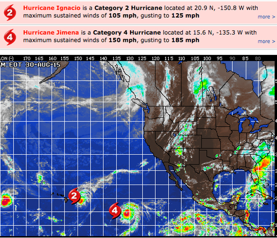
HURRICANE WATCH: Hurricane Ignacio is gradually weakening, and is now a Category 2 hurricane, with sustained winds of 105 mph. Cool water ahead of Ignacio will cause it to weaken further today, eventually becoming a tropical storm by Wednesday or Thursday.
Hurricane Jimena is located about 1,330 miles east of Hilo, Hawaii. Jimena remains a strong Category 4 hurricane. However, Jimena will track west or west-northwest into cooler waters by the middle of this week leading to gradual weakening of the storm in the long range. No direct impact to land is forecast this week, but increased swells may head toward Hawaii late this week.

______________________________________________________________________________
By Tuesday may be okay too with a combination of waist high plus Typhoon Asanti energy, waist high NW wind swell and the possibility of some decent sized Hurricane Jimena surf showing up later in the day.
Tuesday
2015-09-01 Tue 05:34 AM 0.24 feet Low Tide
2015-09-01 Tue 06:27 AM Sunrise
2015-09-01 Tue 09:44 AM Moonset
2015-09-01 Tue 11:51 AM 5.79 feet High Tide
2015-09-01 Tue 06:08 PM 0.54 feet Low Tide
2015-09-01 Tue 07:19 PM Sunset
2015-09-01 Tue 09:32 PM Moonrise
The conditions look okay with SE/SSE breezes in the 3-5 MPH zone until 10AM and 7-9 MPH out of the West in the afternoon. The air temp tops out at 79 degrees.
______________________________________________________________________________
For Wednesday looks interesting with a combination of NW energy from 305-310 degrees and some 12 second + interval swell from Jimena from 195-200 degrees. If things play out according to projections the South facing breaks should go chest to shoulder high and the West facing breaks should be good for chest high peaks!
Wednesday
2015-09-02 Wed 12:14 AM 5.04 feet High Tide
2015-09-02 Wed 06:15 AM 0.82 feet Low Tide
2015-09-02 Wed 06:28 AM Sunrise
2015-09-02 Wed 10:51 AM Moonset
2015-09-02 Wed 12:37 PM 5.74 feet High Tide
2015-09-02 Wed 07:12 PM 0.69 feet Low Tide
2015-09-02 Wed 07:18 PM Sunset
2015-09-02 Wed 10:16 PM Moonrise
The conditions look okay with variable breezes in the 1-4 MPH zone until 10AM and 9-12 MPH out of the West in the afternoon. The air temp drops slightly to 78 degrees.
______________________________________________________________________________
Thursday looks a bit smaller but we’ll see continued energy out of the NW and SW with short interval wind swell and remnants from Jimena.
There may be some subtle changes in size as things play out so stay tuned for updates!
Thursday
2015-09-03 Thu 01:19 AM 4.34 feet High Tide
2015-09-03 Thu 06:28 AM Sunrise
2015-09-03 Thu 07:02 AM 1.45 feet Low Tide
2015-09-03 Thu 11:57 AM Moonset
2015-09-03 Thu 01:30 PM 5.57 feet High Tide
2015-09-03 Thu 07:17 PM Sunset
2015-09-03 Thu 08:29 PM 0.85 feet Low Tide
2015-09-03 Thu 11:01 PM Moonrise
The conditions look pretty good early with E/SE breezes in the 2-4 MPH zone until 11AM and 9-11 MPH out of the West in the afternoon. The air temp drops down to 76 degrees.
______________________________________________________________________________
The current water temps Newport 72 degrees, Huntington 75 degrees, the South Bay showed as 75 degrees, Santa Monica 73 degrees and Malibu 70 degrees.
______________________________________________________________________________
I’ll be back on Tuesday with the 5DAY 4CAST!
______________________________________________________________________________
