______________________________________________________________________________
CLAY MARZO | NICARAGUA LIV'N from JSLV on Vimeo.
______________________________________________________________________________
SOUTHERN CALIFORNIA SURF FORECAST UPDATED 7-13-15
______________________________________________________________________________
Follow us on Facebook Check it out!
______________________________________________________________________________

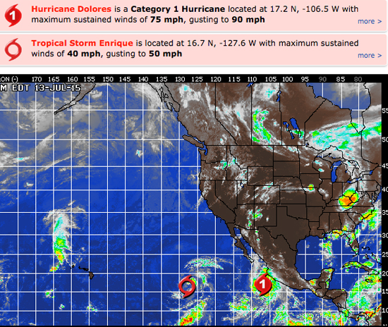
HURRICANE WATCH: Dolores has intensified into a hurricane with maximum sustained winds of 75 mph with higher gusts. The storm is located about 190 miles to the southwest of Manzanillo, Mexico, and is tracking west-northwest, parallel to the coastline. Dolores will continue to intensify over the next few days and become a major hurricane on Wednesday.
We also have Tropical Storm Enrique which is centered 1,225 miles west-southwest of the southern tip of Baja California. The tropical storm is moving northwest at 12 mph. Enrique is forecast to stay over warm water, however, long-range models suggest that unfavorable conditions for intensification exist to the northwest of the storm, and this may prevent further strengthening by the middle of this week. Current forecasts do not have the storm reaching hurricane strength.
Stay tuned… things happen fast in the tropics!
______________________________________________________________________________
By Tuesday morning we’ll return to square one with inconsistent knee to maybe waist high wind swell.
Tuesday
2015-07-14 Tue 03:26 AM -0.73 feet Low Tide
2015-07-14 Tue 04:47 AM Moonrise
2015-07-14 Tue 05:53 AM Sunrise
2015-07-14 Tue 09:52 AM 4.04 feet High Tide
2015-07-14 Tue 02:41 PM 1.97 feet Low Tide
2015-07-14 Tue 06:58 PM Moonset
2015-07-14 Tue 08:06 PM Sunset
2015-07-14 Tue 08:54 PM 6.37 feet High Tide
The conditions should be fair with light breezes out of the SE/SSE in the 3-6 MPH zone until 10AM and 9-12 MPH out of the West in the afternoon. The air temp tops out at 73 degrees.
______________________________________________________________________________
For Wednesday morning we’ll see on significant changes as we continue to see piddly knee to waist high, steeply angled, NW wind swell up and down the coast.
Wednesday
2015-07-15 Wed 04:05 AM -1.00 feet Low Tide
2015-07-15 Wed 05:38 AM Moonrise
2015-07-15 Wed 05:51 AM Sunrise
2015-07-15 Wed 10:28 AM 4.57 feet High Tide
2015-07-15 Wed 03:29 PM 1.84 feet Low Tide
2015-07-15 Wed 06:26 PM New Moon
2015-07-15 Wed 07:37 PM Moonset
2015-07-15 Wed 07:57 PM Sunset
2015-07-15 Wed 09:39 PM 6.78 feet High Tide
The conditions look good for the AM with light & variable, 1-5 MPH breezes out of the SE/SSE until 10AM and those get up to 9-12 MPH in the afternoon. We’re looking at AM clouds/PM sun and the air temp tops out at 74 degrees.
______________________________________________________________________________
Thursday morning we’ll remain stuck in the knee to waist high range everywhere.
* We could start to see some super steeply angled Hurricane swell start to show but nothing is etched in stone quite yet.
Thursday
2015-07-16 Thu 04:39 AM -0.89 feet Low Tide
2015-07-16 Thu 05:52 AM Sunrise
2015-07-16 Thu 06:34 AM Moonrise
2015-07-16 Thu 11:03 AM 4.61 feet High Tide
2015-07-16 Thu 04:07 PM 1.89 feet Low Tide
2015-07-16 Thu 07:57 PM Sunset
2015-07-16 Thu 08:20 PM Moonset
2015-07-16 Thu 10:14 PM 6.55 feet High Tide
The conditionsshould be pretty good for the morning with light and variable, 1-3 MPH S/SE winds early and those get up to 9-11 MPH in the afternoon. The air temp tops out at 73 degrees.
______________________________________________________________________________
The current water temps Newport 65 degrees, Huntington 66 degrees, the South Bay showed as 68 degrees, Santa Monica 68 degrees and Malibu 60 degrees.
______________________________________________________________________________
I’ll be back on Tuesday with the 5DAY 4CAST!
______________________________________________________________________________
