______________________________________________________________________________
[easyrotator]erc_29_1356924531[/easyrotator]
Today’s Slideshow is courtesy of Ruben Pina – Maybe someday we’ll see waves like these again! You can email Ruben at [email protected] to buy some of his killer prints!
______________________________________________________________________________
SOUTHERN CALIFORNIA SURF FORECAST UPDATED 11-14-13
______________________________________________________________________________
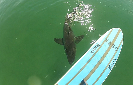
 If you haven’t seen the Video of the Great White Shark encounter, at El Porto, from 10-16-13
Check it out!
______________________________________________________________________________
HURRICANE WATCH 11-14-13
The East Pacific remains relatively quiet. We are seeing more and more cloud clusters showing up off the southwest coast of Mexico in an area of weak shear and lower-than-normal surface pressure. This might be an area to watch for late-season development. If a feature were to form southwest of Mexico later next week, it would probably end up drifting northeast and move inland over Mexico.
______________________________________________________________________________
For Friday morning we’ll see some fresh short interval swell, (8-10 seconds), out of the NW from a steep 310 degree angle. This will put the exposed West facing beaches into the waist to possibly chest high plus zone.
A monster high tide of 6.20 feet at 7:12 AM will bring most spots to a crawl but the tide will race out through the day culminating in a minus tide at 2:06 PM.
Friday
2013-11-15 Fri 12:55 AM 1.40 feet Low Tide
2013-11-15 Fri 04:32 AM Moonset
2013-11-15 Fri 06:26 AM Sunrise
2013-11-15 Fri 07:12 AM 6.20 feet High Tide
2013-11-15 Fri 02:06 PM -0.25 feet Low Tide
2013-11-15 Fri 03:46 PM Moonrise
2013-11-15 Fri 04:50 PM Sunset
2013-11-15 Fri 08:20 PM 4.26 feet High Tide
The conditions look pretty good with offshore winds, out of the SE, in the 4-10 MPH until 2PM and mild West winds in the afternoon. The air temp will top out at 67 degrees.
______________________________________________________________________________
On Saturday morning we’ll see a combination of NW energy with the wind swell being the dominant energy. The best West facing breaks will be in the chest to shoulder high range and we’ll see another giant high tide of 6.27 feet at 7:43AM.
Saturday
2013-11-16 Sat 01:29 AM 1.65 feet Low Tide
2013-11-16 Sat 05:31 AM Moonset
2013-11-16 Sat 06:27 AM Sunrise
2013-11-16 Sat 07:43 AM 6.27 feet High Tide
2013-11-16 Sat 02:43 PM -0.42 feet Low Tide
2013-11-16 Sat 04:26 PM Moonrise
2013-11-16 Sat 04:49 PM Sunset
2013-11-16 Sat 09:02 PM 4.16 feet High Tide
The conditions look pretty good again with variable winds out of the East in the 5-8 MPH zone early and those get up to 10 MPH out of the West in the afternoon. The air temp will dip to a chilly 65 degrees.
______________________________________________________________________________
For Sunday morning we’ll see continued NW energy in the chest to shoulder high range.
Sunday
2013-11-17 Sun 02:01 AM 1.89 feet Low Tide
2013-11-17 Sun 06:27 AM Moonset
2013-11-17 Sun 06:28 AM Sunrise
2013-11-17 Sun 07:16 AM Full Moon
2013-11-17 Sun 08:13 AM 6.24 feet High Tide
2013-11-17 Sun 03:19 PM -0.45 feet Low Tide
2013-11-17 Sun 04:49 PM Sunset
2013-11-17 Sun 05:09 PM Moonrise
2013-11-17 Sun 09:43 PM 4.03 feet High Tide
The conditions look decent with SE winds in the5-8 MPH range until noon then go Westerly at 5-8 MPH for the remainder of the afternoon. The air temp clock in at 65 degrees.
______________________________________________________________________________
The current water temps Newport 61 degrees, Huntington 62 degrees, the South Bay showed as 63 degrees, Santa Monica 63 degrees and Malibu 61 degrees.
______________________________________________________________________________
I’ll be back on Friday with the next update!
______________________________________________________________________________
