______________________________________________________________________________
[easyrotator]erc_29_1356924531[/easyrotator]
Today’s Slideshow is courtesy of Ruben Pina – Maybe someday we’ll see waves like these again! You can email Ruben at [email protected] to buy some of his killer prints!
______________________________________________________________________________
SOUTHERN CALIFORNIA SURF FORECAST UPDATED 11-15-13
______________________________________________________________________________
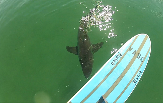
 If you haven’t seen the Video of the Great White Shark encounter, at El Porto, from 10-16-13
Check it out!
______________________________________________________________________________
It’s been quite some time since my last diatribe, but I can’t help but notice that the surfing population has quadrupled over the last year. This morning I could of hopped across the ocean from head to head from the El Porto Jetty all the way down to the Manhattan Pier and not gotten my feet wet. Where are all these people coming from, and why I am I even irritated about it!
I’ll admit that I am out there, and thus part of the problem, but at least I have a general understanding of what’s going on. I dodged so many nimrods this morning that it felt like I was in a bad Drivers Ed film. Not sure if I should, yell at them, talk to them, shake my head and paddle away or just find another way to get my kicks.
Everyone has the right to surf but if you’re just learning, go to Dockweiler or another obscure beach break and get at least a fundamental understanding of what you’re doing before you paddle out at the main peak and start ditching your board. A blunt force shot of fiberglass to the head is no joking matter! Basic common sense should prevail… right?
______________________________________________________________________________
HURRICANE WATCH 11-15-13
A broad area of low pressure is located about 525 miles to the west-southwest of Manzanillo, Mexico. This low has a window of roughly 36 hours for it to become an organized tropical system as it moves northward into marginal environmental conditions.
Beyond that time frame, any further development would be unlikely due to stronger shear. Even so, this feature will produce heavy rains in parts of southwestern Mexico over the next few days.
Elsewhere across the basin, no tropical development is expected.
______________________________________________________________________________
On Saturday morning we’ll see a combination of NW energy with the wind swell being the dominant energy. The best West facing breaks will be in the chest to shoulder high range and we’ll see another giant high tide of 6.27 feet at 7:43AM.
Saturday
2013-11-16 Sat 01:29 AM 1.65 feet Low Tide
2013-11-16 Sat 05:31 AM Moonset
2013-11-16 Sat 06:27 AM Sunrise
2013-11-16 Sat 07:43 AM 6.27 feet High Tide
2013-11-16 Sat 02:43 PM -0.42 feet Low Tide
2013-11-16 Sat 04:26 PM Moonrise
2013-11-16 Sat 04:49 PM Sunset
2013-11-16 Sat 09:02 PM 4.16 feet High Tide
The conditions look pretty good again with variable winds out of the East in the 5-8 MPH zone early and those get up to 10 MPH out of the West in the afternoon. The air temp will dip to a chilly 65 degrees.
______________________________________________________________________________
For Sunday morning we’ll see continued NW energy in the chest to shoulder high range.
Sunday
2013-11-17 Sun 02:01 AM 1.89 feet Low Tide
2013-11-17 Sun 06:27 AM Moonset
2013-11-17 Sun 06:28 AM Sunrise
2013-11-17 Sun 07:16 AM Full Moon
2013-11-17 Sun 08:13 AM 6.24 feet High Tide
2013-11-17 Sun 03:19 PM -0.45 feet Low Tide
2013-11-17 Sun 04:49 PM Sunset
2013-11-17 Sun 05:09 PM Moonrise
2013-11-17 Sun 09:43 PM 4.03 feet High Tide
The conditions look decent with SE winds in the5-8 MPH range until noon then go Westerly at 5-8 MPH for the remainder of the afternoon. The air temp clock in at 65 degrees.
______________________________________________________________________________
Monday morning is looking pretty small with waist high plus leftovers on the right tide. Not much to sink your teeth into but if you have enough foam you may be able to sneak in a couple waves before, or after, the tide kills it.
Monday
2013-11-18 Mon 02:32 AM 2.11 feet Low Tide
2013-11-18 Mon 06:29 AM Sunrise
2013-11-18 Mon 07:21 AM Moonset
2013-11-18 Mon 08:43 AM 6.12 feet High Tide
2013-11-18 Mon 03:54 PM -0.37 feet Low Tide
2013-11-18 Mon 04:48 PM Sunset
2013-11-18 Mon 05:55 PM Moonrise
2013-11-18 Mon 10:24 PM 3.89 feet High Tide
The conditions look fair with variable winds in the 0-3 MPH zone until 10AM and mild West winds at 7-9 MPH in the afternoon. The air temp will top out at 66 degrees.
______________________________________________________________________________
For Tuesday morning looks bleak as conditions deteriorate and the swell backs down further. The best spots will see knee to waist high surf as a subtle tide push helps out the early morning sessions.
Tuesday
2013-11-19 Tue 03:02 AM 2.32 feet Low Tide
2013-11-19 Tue 06:30 AM Sunrise
2013-11-19 Tue 08:12 AM Moonset
2013-11-19 Tue 09:14 AM 5.92 feet High Tide
2013-11-19 Tue 04:30 PM -0.20 feet Low Tide
2013-11-19 Tue 04:48 PM Sunset
2013-11-19 Tue 06:43 PM Moonrise
2013-11-19 Tue 11:07 PM 3.75 feet High Tide
The conditions look mediocre at best with West winds in the 1-4 MPH until 10AM and 8-12 MPH winds in the afternoon. The air temp will top out at 63 degrees.
______________________________________________________________________________
The current water temps Newport 62 degrees, Huntington 62 degrees, the South Bay showed as 64 degrees, Santa Monica 62 degrees and Malibu 62 degrees.
______________________________________________________________________________
I’ll be back on Sunday with the next update!
______________________________________________________________________________
