______________________________________________________________________________
[easyrotator]erc_90_1354553602[/easyrotator]
Today’s Slideshow is courtesy of Dave Waters – The South Bay Archives Check out more pics
______________________________________________________________________________
SOUTHERN CALIFORNIA SURF FORECAST UPDATED 11-18-13
______________________________________________________________________________
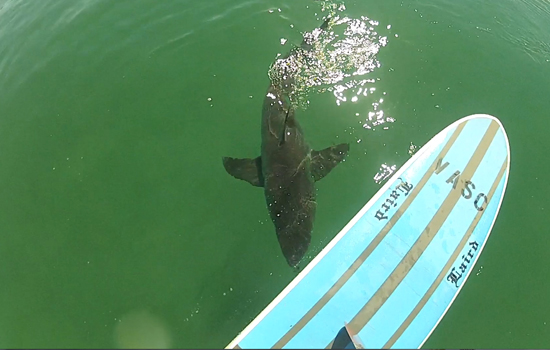
 If you haven’t seen the Video of the Great White Shark encounter, at El Porto, from 10-16-13
Check it out!
______________________________________________________________________________
Slim picken’s lately and it looks like Mother Nature will be doing us no favors for this upcoming week. We’re in for more SMALL surf through Thursday, but could see a little bump up by next Friday. Stay tuned!
______________________________________________________________________________
HURRICANE WATCH 11-18-13
There are currently no areas of development that we are watching. The Eastern Pacific Basin is expected to remain quiet for at least the next couple of days.
______________________________________________________________________________
For Tuesday morning looks bleak as conditions deteriorate a little bit and the swell backs down further. The best spots will see knee to knee to maybe waist high surf as a subtle tide push helps out the early morning sessions.
Tuesday
2013-11-19 Tue 03:02 AM 2.32 feet Low Tide
2013-11-19 Tue 06:30 AM Sunrise
2013-11-19 Tue 08:12 AM Moonset
2013-11-19 Tue 09:14 AM 5.92 feet High Tide
2013-11-19 Tue 04:30 PM -0.20 feet Low Tide
2013-11-19 Tue 04:48 PM Sunset
2013-11-19 Tue 06:43 PM Moonrise
2013-11-19 Tue 11:07 PM 3.75 feet High Tide
The conditions should be okay with variable winds in the 1-4 MPH until 10AM and 6-8 MPH winds in the afternoon. The air temp will top out at 63 degrees.
______________________________________________________________________________
Wednesday morning looks no better with knee high plus surf for the best spots.
Wednesday
2013-11-20 Wed 03:34 AM 2.54 feet Low Tide
2013-11-20 Wed 06:31 AM Sunrise
2013-11-20 Wed 09:00 AM Moonset
2013-11-20 Wed 09:45 AM 5.64 feet High Tide
2013-11-20 Wed 04:47 PM Sunset
2013-11-20 Wed 05:08 PM 0.04 feet Low Tide
2013-11-20 Wed 07:34 PM Moonrise
2013-11-20 Wed 11:55 PM 3.63 feet High Tide
The conditions look okay with variable winds out of the East in the 3-5 MPH zone until 11AM and those get up to 8 MPH out of the West in the afternoon. The air temp will be 65 degrees on the sand.
______________________________________________________________________________
For Thursday morning we’ll see continued knee to waist high surf at the best breaks.
Thursday
2013-11-21 Thu 04:09 AM 2.75 feet Low Tide
2013-11-21 Thu 06:32 AM Sunrise
2013-11-21 Thu 09:43 AM Moonset
2013-11-21 Thu 10:19 AM 5.29 feet High Tide
2013-11-21 Thu 04:47 PM Sunset
2013-11-21 Thu 05:49 PM 0.32 feet Low Tide
2013-11-21 Thu 08:26 PM Moonrise
The conditions look decent with variable winds in the 2-4 MPH range until noon then go Westerly at 6-8 MPH for the remainder of the afternoon. There’s a 30% chance of rain and the air temp clock in at 65 degrees.
______________________________________________________________________________
The current water temps Newport 63 degrees, Huntington 63 degrees, the South Bay showed as 63 degrees, Santa Monica 62 degrees and Malibu 62 degrees.
______________________________________________________________________________
I’ll be back on Tuesday with the 5DAY 4CAST!
______________________________________________________________________________
