______________________________________________________________________________
[easyrotator]erc_87_1445453612[/easyrotator] The South Bay today 10-19-15 – Shots Courtesy of Lucio Gomes of http://portosurfer.com
______________________________________________________________________________
SOUTHERN CALIFORNIA SURF FORECAST UPDATED 10-21-15
______________________________________________________________________________
Follow us on Facebook Check it out!
______________________________________________________________________________
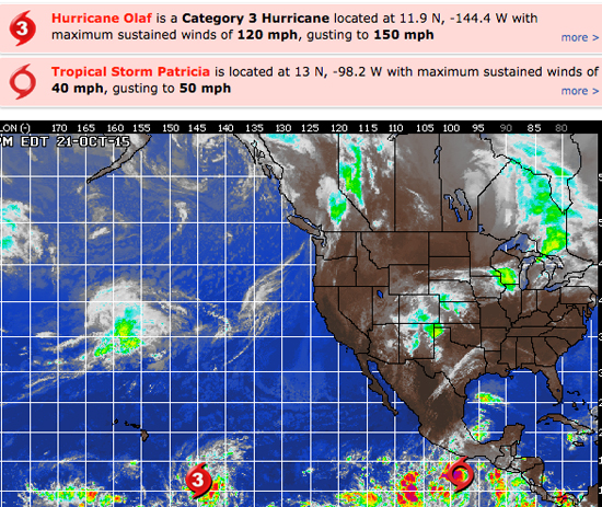
HURRICANE WATCH: Hurricane Olaf continues to gather strength over the open waters of the central Pacific this morning. Olaf’s sustained winds have increased to 150 mph with gusts up to 185 mph possible. This Category 4 hurricane is located about 1,115 miles to the east-southeast of Hilo, Hawaii, and is tracking west-northwest at 10 mph. Olaf is flirting with category 5 status, and may reach it in the next 24 hours. Olaf has been tracking nearly due west for the last several days and this slight turn to the north will be followed by an even greater bend to the north during the next 24 hours. This new northward path will keep Olaf well east of Hawaii and would result in no direct impact to land. However, this powerful storm will produce very rough surf along the southeast-facing shores of Hawaii later this week.
Tropical Depression Twenty-E has formed near the Gulf of Tehuantepec late Tuesday morning. Further strengthening is expected as conditions will remain favorable as it moves westward and Twenty-E is expected to become a tropical storm and eventually a hurricane. The name it would acquire would be Patricia.

______________________________________________________________________________
Thursday morning should be another fun day for waves with small, NW wind swell in the waist high plus range, (300-310 degrees), pulses out of the SW, (15 seconds from a 210 degree angle), and continued Hurricane Olaf swell in the chest high plus range.
Thursday
2015-10-22 Thu 01:34 AM Moonset
2015-10-22 Thu 06:27 AM 4.51 feet High Tide
2015-10-22 Thu 07:04 AM Sunrise
2015-10-22 Thu 12:03 PM 2.22 feet Low Tide
2015-10-22 Thu 03:06 PM Moonrise
2015-10-22 Thu 05:52 PM 4.87 feet High Tide
2015-10-22 Thu 06:11 PM Sunset
The conditions look fair with variable breezes out of the East in the 2-5 MPH zone until noon and 6-9 MPH out of the West in the afternoon. The air temp backs down to a still toasty 77 degrees.
______________________________________________________________________________
By Friday we should see some medium, 12-14 second interval energy come down the line from a 300 degree angle. Not a real haymaker, but expect the West facing breaks to see waist to chest high surf with some larger sets at the standouts!
We’ll also see continued SW energy in the chest high range with 13-15 second intervals for a 210-215 degree angle).
*Hurricane swell status pending. Check back tomorrow!
Friday
2015-10-23 Fri 12:30 AM 0.41 feet Low Tide
2015-10-23 Fri 02:39 AM Moonset
2015-10-23 Fri 07:01 AM 5.04 feet High Tide
2015-10-23 Fri 07:05 AM Sunrise
2015-10-23 Fri 12:57 PM 1.47 feet Low Tide
2015-10-23 Fri 03:48 PM Moonrise
2015-10-23 Fri 06:10 PM Sunset
2015-10-23 Fri 06:53 PM 5.12 feet High Tide
The conditions look good with offshore breezes in the 2-5 MPH zone until noon and 9-11 MPH out of the West in the afternoon. The air temp tops out at 78 degrees.
______________________________________________________________________________
For Saturday morning we should swell from Olaf, (size TBD) and some new, fairly long interval SW swell fill in through the day. We should see waist to chest high plus sets in the AM and those will slowly increase in size and consistency as the day wears on.
*Hurricane swell status pending. Check back tomorrow!
Saturday
2015-10-24 Sat 01:12 AM 0.33 feet Low Tide
2015-10-24 Sat 03:46 AM Moonset
2015-10-24 Sat 07:06 AM Sunrise
2015-10-24 Sat 07:35 AM 5.59 feet High Tide
2015-10-24 Sat 01:46 PM 0.71 feet Low Tide
2015-10-24 Sat 04:29 PM Moonrise
2015-10-24 Sat 06:09 PM Sunset
2015-10-24 Sat 07:47 PM 5.30 feet High Tide
The conditions look fair + for the AM with variable breezes in the 1-3 MPH zone until noon and 9-11 MPH out of the West in the afternoon. The air temp tops out at 83 degrees.
______________________________________________________________________________
Sunday should be pretty good again with continued SW ground swell from that same 200-210 degree angle. Most South facing breaks will see chest to shoulder high sets with the most exposed breaks in the San O’/OC area getting some larger waves mixed in.
NW wind swell will blend into the background with 10-12 second intervals from a 300-310 degree angle.
*Hurricane swell status pending. Check back tomorrow!
Sunday
2015-10-25 Sun 01:52 AM 0.35 feet Low Tide
2015-10-25 Sun 04:55 AM Moonset
2015-10-25 Sun 07:07 AM Sunrise
2015-10-25 Sun 08:09 AM 6.10 feet High Tide
2015-10-25 Sun 02:32 PM 0.03 feet Low Tide
2015-10-25 Sun 05:11 PM Moonrise
2015-10-25 Sun 06:08 PM Sunset
2015-10-25 Sun 08:39 PM 5.35 feet High Tide
The conditions look okay with variable breezes in the 1-6 MPH zone until noon and 7-10 MPH out of the West in the afternoon. The air temp tops out at 82 degrees.
______________________________________________________________________________
The current water temps Newport 70 degrees, Huntington 68 degrees, the South Bay showed as 73 degrees, Santa Monica 68 degrees and Malibu 70 degrees.
______________________________________________________________________________
I’ll be back on Thursday with the next update!
______________________________________________________________________________
