______________________________________________________________________________
[easyrotator]erc_90_1441297359[/easyrotator]
El Porto 8-31-15 Pics by Michael Durand
______________________________________________________________________________
SOUTHERN CALIFORNIA SURF FORECAST UPDATED 9-4-15
______________________________________________________________________________
Follow us on Facebook Check it out!
______________________________________________________________________________
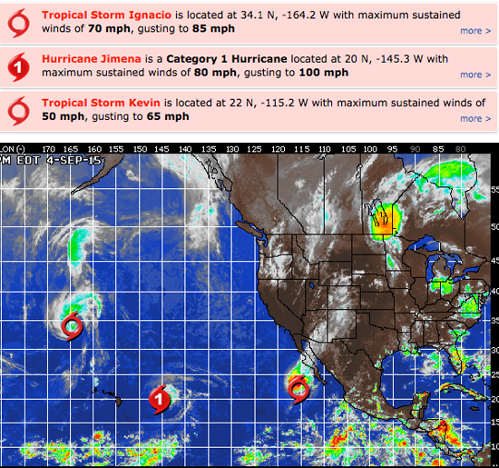
HURRICANE WATCH: Three named storms continue to roam portions of the eastern and central Pacific basins. In addition, we are watching low pressure southwest of Manzanillo, Mexico that has potential to develop by early next week.
Hurricane Ignacio has weakened into a tropical storm well north of Hawaii and it is tracking to the north-northwest and picking up forward speed.
Even though Ignacio is located well to the north of Hawaii, it is still disrupting the normal trade wind flow across the islands. The result is that slow-moving downpours have been dropping excessive rain in some areas, leading to a flooding threat.
Jimena will continue to produce rough surf and large swells that will pound the Hawaiian Islands, particularly the east-facing shores. Steering currents will cause Jimena to shift more to the west next week and some computer models show a track to the west-southwest and closer to the Hawaiian Islands late next week.
Tropical Storm Kevin is located about 345 miles west of the southern tip of Baja California. Kevin is tracking to the north and it is encountering strong southerly wind and this will cause the tropical storm to weaken quickly over the next 12-24 hours.
We are watching a broad area of low pressure several hundred miles to the south of Manzanillo, Mexico at this time. This system is tracking off to the northwest at 5-10 mph and should slowly develop over the weekend within favorable environmental conditions.

______________________________________________________________________________
By Saturday should be interesting with a combination of short interval NW energy, SW energy and a chance at some surf from TD-14E, (which turned into Hurricane Kevin).
Wave heights are up in the air right now if Kevin enters the fray, but it’s pretty safe to assume that the NW facing breaks should go waist to chest high and the South facing breaks will do the same.
Saturday
2015-09-05 Sat 02:56 AM Last Quarter
2015-09-05 Sat 04:33 AM 3.54 feet High Tide
2015-09-05 Sat 06:30 AM Sunrise
2015-09-05 Sat 09:18 AM 2.49 feet Low Tide
2015-09-05 Sat 01:57 PM Moonset
2015-09-05 Sat 03:52 PM 5.24 feet High Tide
2015-09-05 Sat 07:14 PM Sunset
2015-09-05 Sat 11:27 PM 0.69 feet Low Tide
The conditions look okay with SE/SSE breezes in the 3-5 MPH zone until 10AM and 7-11 MPH out of the West in the afternoon. The air temp remains at 76 degrees.
______________________________________________________________________________
By Sunday a more dominant SW swell will enter the picture and should dish up shoulder to head high sets with some larger sets in the San O’ and OC regions.
This energy will move in from a fairly liberal 200-210 degree angle with powerful 18+ second intervals and should get into any beach with a peek at the S/SW.
There will also be continued NW wind swell in the waist high plus range.
Sunday
2015-09-06 Sun 12:40 AM Moonrise
2015-09-06 Sun 06:12 AM 3.72 feet High Tide
2015-09-06 Sun 06:30 AM Sunrise
2015-09-06 Sun 10:53 AM 2.62 feet Low Tide
2015-09-06 Sun 02:51 PM Moonset
2015-09-06 Sun 05:11 PM 5.25 feet High Tide
2015-09-06 Sun 07:13 PM Sunset
The conditions look okay with light and variable breezes in the 1-2 MPH zone until 10AM and 7-10 MPH out of the West in the afternoon. The air temp tops out at 78 degrees.
______________________________________________________________________________
The current water temps Newport 72 degrees, Huntington 75 degrees, the South Bay showed as 75 degrees, Santa Monica 73 degrees and Malibu 70 degrees.
______________________________________________________________________________
I’ll be back on Sunday with the next update!
______________________________________________________________________________
