______________________________________________________________________________
[easyrotator]erc_17_1410185859[/easyrotator]
Today’s Slideshow is courtesy of Swellmagnet – Chicama Peru – Here’s a few shots of the point and a couple I took waking the streets of Chicama away from the resort.
______________________________________________________________________________
SOUTHERN CALIFORNIA SURF FORECAST UPDATED 9-8-14
______________________________________________________________________________
SHARK UPDATE To see the latest shark updates follow us on Facebook Check it out!
______________________________________________________________________________

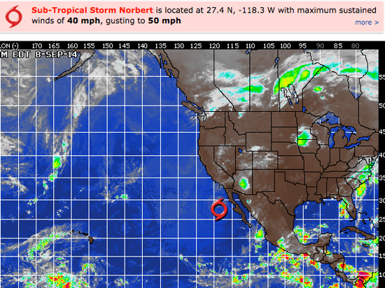
HURRICANE WATCH September 8th, 2014 – Cool waters have taken their toll on Norbert overnight and the system is no longer considered a tropical cyclone. This weakening trend will continue over the next 48 hours as the system remains over waters too cool to support tropical activity.
In addition, Norbert has stirred up the waters in the eastern Pacific as large swells continue to affect portions of the southwestern Mexican coast and the southern portion of the Gulf of California. These large swells and the associated rough surf, dangerous rip currents and potential damage to coastal structures, will spread up the coast of Baja California and into Southern California today.
The next area to develop is already visible on satellite south of the southern coast of Mexico. This cluster of showers and thunderstorms will be slowly moving to the northwest over the next couple of days. Relatively low wind shear, warm ocean temperatures and distance from the equator will help the system develop over the next couple of days, and it will likely be the next tropical cyclone in the East Pacific.
______________________________________________________________________________
Tuesday morning should still be pretty good as the swell continues through the AM and does a slow methodical fade through the day. The super exposed South facing breaks, that are accepting of that steep, 170 degree angle, should see head high sets with a few larger waves sneaking in.
We’ll also see some SW ground swell from a more liberal 200 degrees in play, and that should be good for waist high plus sets at most South facing beaches.
Tuesday
2014-09-09 Tue 03:55 AM -0.34 feet Low Tide
2014-09-09 Tue 06:33 AM Sunrise
2014-09-09 Tue 07:13 AM Moonset
2014-09-09 Tue 10:07 AM 5.84 feet High Tide
2014-09-09 Tue 04:10 PM 0.26 feet Low Tide
2014-09-09 Tue 07:08 PM Sunset
2014-09-09 Tue 07:37 PM Moonrise
2014-09-09 Tue 10:19 PM 6.03 feet High Tide
The conditions look okay with S/SE winds in the 2-3 MPH zone until 10AM and then those bump up to 6-10 MPH in the afternoon. The air temp tops out at 79 degrees.
___________________________________________________________________________
Wednesday morning looks smaller as Norbert pulls a Houdini early and there are only sporadic pulses left from the SW energy. We will however have a small burst of of 200 degree angle SW fill in overnight. This should be good for waist to chect high sets at the better S/SW facing beaches.
Wednesday
2014-09-10 Wed 04:32 AM 0.03 feet Low Tide
2014-09-10 Wed 06:33 AM Sunrise
2014-09-10 Wed 08:21 AM Moonset
2014-09-10 Wed 10:45 AM 5.99 feet High Tide
2014-09-10 Wed 04:59 PM 0.18 feet Low Tide
2014-09-10 Wed 07:07 PM Sunset
2014-09-10 Wed 08:17 PM Moonrise
2014-09-10 Wed 11:08 PM 5.51 feet High Tide
The conditions look pretty good with S/SE winds in the 1-2 MPH zone until 10AM and then those pick up to 9-11 MPH in the afternoon. The air temp tops out at 76
___________________________________________________________________________
Thursday morning should have some fun sets out of the SW as that long period swell from an angle of 200 degrees peaks in the morning. This should put the better South facing beaches in the waist to chest high zone.
Thursday
2014-09-11 Thu 05:10 AM 0.54 feet Low Tide
2014-09-11 Thu 06:34 AM Sunrise
2014-09-11 Thu 09:28 AM Moonset
2014-09-11 Thu 11:24 AM 5.98 feet High Tide
2014-09-11 Thu 05:51 PM 0.29 feet Low Tide
2014-09-11 Thu 07:06 PM Sunset
2014-09-11 Thu 08:59 PM Moonrise
The conditions look okay tolerable with onshore winds in the 2-5 MPH zone until 10AM and then those pick up to 10-12 MPH in the afternoon. The air temp tops out at scorching 83 degrees.
___________________________________________________________________________
By Friday morning should have at least a little meat left on the bone with smallish, sporadic, SW peaks in the waist to very occasional chest high zone.
Friday
2014-09-12 Fri 12:00 AM 4.88 feet High Tide
2014-09-12 Fri 05:48 AM 1.12 feet Low Tide
2014-09-12 Fri 06:35 AM Sunrise
2014-09-12 Fri 10:32 AM Moonset
2014-09-12 Fri 12:06 PM 5.81 feet High Tide
2014-09-12 Fri 06:48 PM 0.53 feet Low Tide
2014-09-12 Fri 07:04 PM Sunset
2014-09-12 Fri 09:42 PM Moonrise
The conditions look okay with light onshore winds in the 1-5 MPH zone until 10AM and then those pick up to 10-12 MPH in the afternoon. The air temp tops out at 83 degrees again.
______________________________________________________________________________
The current water temps Newport 68degrees, Huntington 71 degrees, the South Bay showed as 74 degrees, Santa Monica 73 degrees and Malibu 70 degrees.
______________________________________________________________________________
I’ll be back on Tuesday night with the 5DAY 4CAST!
______________________________________________________________________________
