Today’s Slideshow brought to you by Brian McStotts
[easyrotator]erc_31_1352058372[/easyrotator]
SURF FORECAST UPDATED 11-2-12
______________________________________________________________
As you can see, we’ve redesigned the site and I hope you’re pleased with the new look and feel of it. There is a definite learning curve for the site management so please be patient as I get things up to speed over the next month or so. If you have any other suggestions on ways to improve swellmagnet, feel free to drop us an email Thx, the SM TEAM.
______________________________________________________________
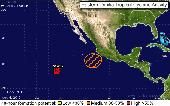
HURRICANE REPORT – Down south Tropical Storm Rosa continues to churn away now moving to the west northwest well away from any landfall, there’s also another little disturbance on the tail end.

______________________________________________________________
Monday morning could be a fun one, as winds, weather and swell all look to chip in. I can’t make any promises as far as shape goes, (for the beach breaks), so you may be better served to hunt down a reef or a point. The better West facing breaks should see waist to chest high sets as some long interval and medium interval energy combine from 300-310 degrees.
Monday
2012-11-05 Mon 02:43 AM 3.53 feet High Tide
2012-11-05 Mon 06:05 AM 3.26 feet Low Tide
2012-11-05 Mon 06:10 AM Sunrise
2012-11-05 Mon 11:31 AM Moonset
2012-11-05 Mon 12:19 PM 4.68 feet High Tide
2012-11-05 Mon 04:53 PM Sunset
2012-11-05 Mon 08:18 PM 0.90 feet Low Tide
2012-11-05 Mon 10:35 PM Moonrise
The conditions should be fantastic as the high pressure holds and kicks up NE winds in the 5-9 MPH zone until 1PM and afternoon onshores up to 8 MPH. Look for a high air temp of 83 degrees.
______________________________________________________________
Tuesday morning like looks another okay day for waves as the first, steeply angled, NW swell begins to fade, but some smaller, 12-14 second interval swell, from a 300 degree angle, fills in for the morning session. The better West facing breaks should see waist to chest high sets and beautiful conditions.
Tuesday
2012-11-06 Tue 04:10 AM 3.80 feet High Tide
2012-11-06 Tue 06:18 AM Sunrise
2012-11-06 Tue 08:38 AM 3.25 feet Low Tide
2012-11-06 Tue 12:15 PM Moonset
2012-11-06 Tue 01:50 PM 4.12 feet High Tide
2012-11-06 Tue 04:36 PM Last Quarter
2012-11-06 Tue 04:56 PM Sunset
2012-11-06 Tue 09:24 PM 1.04 feet Low Tide
2012-11-06 Tue 11:36 PM Moonrise
The conditions should be excellent again with NE winds in the 2-9 MPH zone until 1PM and light onshore’s into the afternoon. Look for a high air temp of 80 degrees.
______________________________________________________________
Wednesday morning should see another little bump in size as the a combination of NW swell puts the expose breaks into the chest to shoulder high range. The weather will start to change dramatically but the winds are scripted to remain tolerable.
Wednesday
Wednesday
2012-11-07 Wed 04:42 AM 4.15 feet High Tide
2012-11-07 Wed 06:19 AM Sunrise
2012-11-07 Wed 10:12 AM 2.78 feet Low Tide
2012-11-07 Wed 12:50 PM Moonset
2012-11-07 Wed 03:25 PM 4.01 feet High Tide
2012-11-07 Wed 04:55 PM Sunset
2012-11-07 Wed 10:14 PM 1.05 feet Low Tide
The conditions look fair with variable winds in the 2-6 MPH zone until noon and afternoon onshores up into the 10-16 MPH range. Look for a high air temp of 74 degrees.
______________________________________________________________
Thursday morning looks smaller as what’s left of the NW energy backs down into the waist to chest high range. The good news is that some fresh, wind swell will move in and we’ll also see some long interval, S/SW swell start to show up later in the day. Not quite the wave bonanza I was hoping for, but there should at least be something to ride all week long.
Thursday
2012-11-08 Thu 12:36 AM Moonrise
2012-11-08 Thu 05:09 AM 4.58 feet High Tide
2012-11-08 Thu 06:20 AM Sunrise
2012-11-08 Thu 11:11 AM 2.11 feet Low Tide
2012-11-08 Thu 01:24 PM Moonset
2012-11-08 Thu 04:42 PM 4.08 feet High Tide
2012-11-08 Thu 04:54 PM Sunset
2012-11-08 Thu 10:57 PM 1.07 feet Low Tide
The conditions will deteriorate a bit but still remain fairly calm in the morning. We’re anticipating 1-4 MPH breezes out of the West until 11AM and afternoon onshores up into the 8-10 MPH range. Look for a high air temp of 63 degrees.
______________________________________________________________
The current water temps are as follows – Newport 64 degrees, Huntington 65 degrees, the South Bay showed as 65 degrees, Santa Monica 64 degrees and Malibu 63 degrees.
______________________________________________________________
I’ll be back on Monday with the next update.
______________________________________________________________
