Today’s Slideshow brought to you by Brian McStotts
[easyrotator]erc_39_1351899535[/easyrotator]
SURF FORECAST UPDATED 11-2-12
______________________________________________________________
As you can see, we’ve redesigned the site and I hope you’re pleased with the new look and feel of it. There is a definite learning curve for the site management so please be patient as I get things up to speed over the next month or so. If you have any other suggestions on ways to improve swellmagnet, feel free to drop us an email Thx, the SM TEAM.
______________________________________________________________
A little bigger than anticipated this morning. Top spots in the South Bay saw some overhead meat grinder barrels. Plenty of swell out there but until we get some sand bars have that Netti Pot ready. I think I went 0-10 on barrels today and got pitched a couple times too, nonetheless, it was nice to see some solid lines coming through! Looks like another decent swell should roll in by Monday morning.
______________________________________________________________
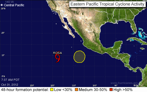
HURRICANE REPORT – the center of Tropical Storm Rosa was located near latitude 13.9 north and longitude 118.4 west, about 825 miles southwest of Cabo San Lucas, Mexico. Rosa had maximum sustained winds near 50 mph and was moving toward the west-southwest near 2 mph. Rosa is expected to drift to the southwest and weaken over the next couple of days.

______________________________________________________________
Saturday morning looks to be smaller with just waist high plus sets for the top spots. I was just down in the South Bay though, 4:30 PM Friday, and it looks like there’s still plenty of swell left so it may be worth a cam check in the AM.
Saturday
2012-11-03 Sat 01:25 AM 3.41 feet High Tide
2012-11-03 Sat 05:11 AM 2.90 feet Low Tide
2012-11-03 Sat 07:15 AM Sunrise
2012-11-03 Sat 11:19 AM Moonset
2012-11-03 Sat 11:36 AM 5.14 feet High Tide
2012-11-03 Sat 05:58 PM Sunset
2012-11-03 Sat 07:22 PM 0.69 feet Low Tide
2012-11-03 Sat 09:48 PM Moonrise
The conditions look great with NE winds in the 2-6 MPH zone until noon and afternoon onshores up into the 6-8 MPH range. Look for a high air temp of 75 degrees.
______________________________________________________________
Sunday morning looks smaller as what’s left of the NW energy peters out into the knee to waist high range. The good news is that some fresh, 16-18 second interval ground swell will will start to fill overnight. Not a huge swell and not the greatest angle, (310 degrees), but it should put the most exposed West facing breaks into the chest to shoulder high plus zone for Monday morning.
Sunday
2012-11-04 Sun 01:45 AM 3.37 feet High Tide
2012-11-04 Sun 04:54 AM 3.15 feet Low Tide
2012-11-04 Sun 06:16 AM Sunrise
2012-11-04 Sun 11:00 AM Moonset
2012-11-04 Sun 11:20 AM 4.79 feet High Tide
2012-11-04 Sun 04:57 PM Sunset
2012-11-04 Sun 07:20 PM 0.88 feet Low Tide
2012-11-04 Sun 09:42 PM Moonrise
The conditions don’t look really nice as the high pressure strengthens and kicks up NE winds in the 7-12 MPH zone until 1PM and afternoon onshores up into the 10-13 MPH range. Look for a high air temp of 80 degrees.
______________________________________________________________
Monday morning could be a fun one, as winds, weather and swell all look to chip in. I can’t make any promises as far as shape goes, (for the beach breaks), so you may be better serves to hunt down a reef or a point.
Monday
2012-11-05 Mon 02:43 AM 3.53 feet High Tide
2012-11-05 Mon 06:05 AM 3.26 feet Low Tide
2012-11-05 Mon 06:10 AM Sunrise
2012-11-05 Mon 11:31 AM Moonset
2012-11-05 Mon 12:19 PM 4.68 feet High Tide
2012-11-05 Mon 04:53 PM Sunset
2012-11-05 Mon 08:18 PM 0.90 feet Low Tide
2012-11-05 Mon 10:35 PM Moonrise
The conditions fantastic as the high pressure holds and kicks up NE winds in the 5-9 MPH zone until 1PM and afternoon onshores up to 8 MPH. Look for a high air temp of 83 degrees.
______________________________________________________________
Tuesday morning like looks another okay day for waves as the first, steeply angled NW swell begins to fade, but some smaller, 12-14 second interval swell, from a 300 degree angle, fills in for the morning session. The better West facing breaks should see waist to chest high sets and beautiful conditions.
Tuesday
2012-11-06 Tue 04:10 AM 3.80 feet High Tide
2012-11-06 Tue 06:18 AM Sunrise
2012-11-06 Tue 08:38 AM 3.25 feet Low Tide
2012-11-06 Tue 12:15 PM Moonset
2012-11-06 Tue 01:50 PM 4.12 feet High Tide
2012-11-06 Tue 04:36 PM Last Quarter
2012-11-06 Tue 04:56 PM Sunset
2012-11-06 Tue 09:24 PM 1.04 feet Low Tide
2012-11-06 Tue 11:36 PM Moonrise
The conditions should be excellent again with NE winds in the 2-9 MPH zone until 1PM and light onshore’s into the afternoon. Look for a high air temp of 80 degrees.
______________________________________________________________
The current water temps are as follows – Newport 64 degrees, Huntington 65 degrees, the South Bay showed as 65 degrees, Santa Monica 64 degrees and Malibu 62 degrees.
______________________________________________________________
I’ll be back on Sunday with the next update.
______________________________________________________________
